A Conversation with NASA Disasters Program Associate Manager, John Murray
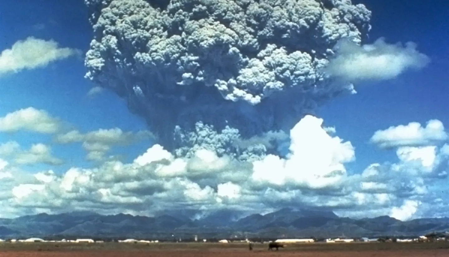
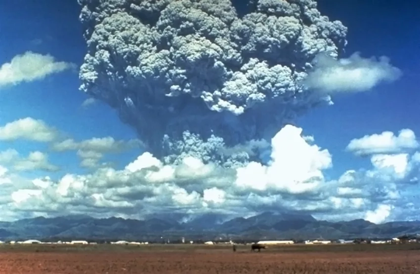
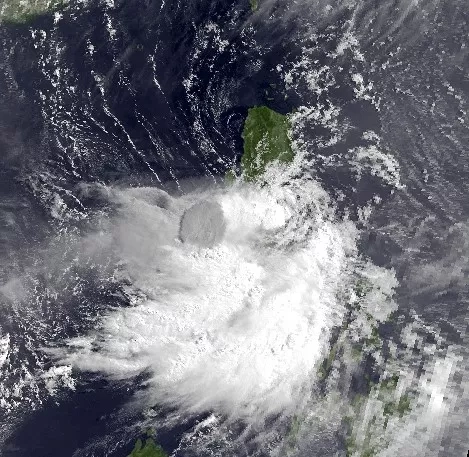
The second-largest volcanic eruption of the 20th century occurred at Mount Pinatubo in the Philippines on June 15, 1991. By far the largest eruption in the past 100 years to affect a densely populated area, Pinatubo produced high-speed avalanches of pyroclastic flows and a cloud of volcanic ash hundreds of miles across. Meanwhile, Typhoon Yunya brought cascading hazards such as flooding and fast-moving lahars when it arrived within 75 km of the volcano during the eruption’s peak activity.
The effects of Mt. Pinatubo’s eruption combined with Typhoon Yunya were devastating. The disaster impacted approximately two million people directly, primarily by widespread ashfall and damaged crops. Reports estimated $700 million in damage, including $100 million of damages to aircraft flying at the time of the eruption, with the rest a combination of agriculture, forestry and land.
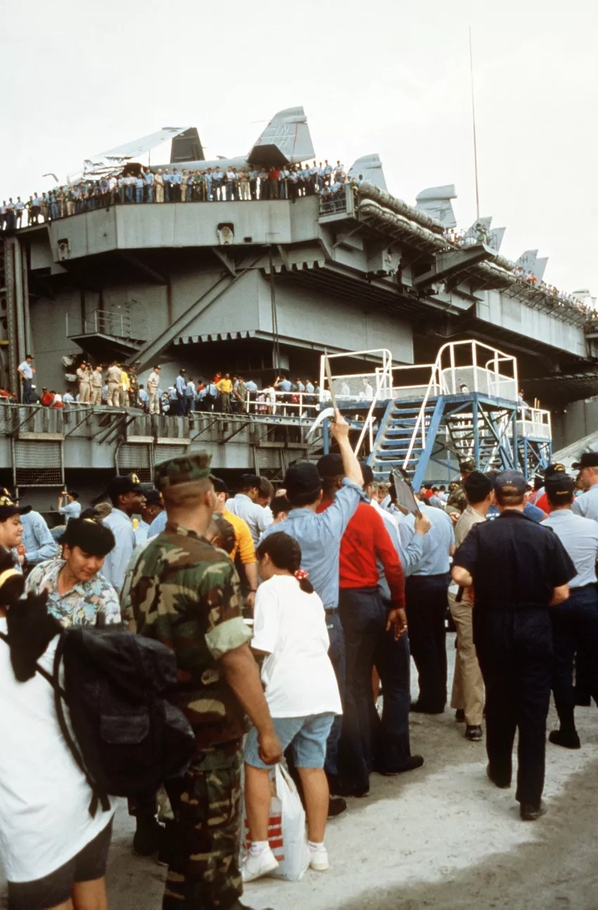
Still, because the eruption was forecast by scientists from the Philippine Institute of Volcanology and Seismology (PHIVOLCS) and the U.S. Geological Survey (USGS), civil and military leaders were able to undertake massive evacuations and measures to protect property before the eruption. Seventeen ships evacuated tens of thousands of U.S. Department of Defense civilian personnel and their dependents from Clark Air Base and U.S. Naval Base Subic Bay during "Operation Fiery Vigil." Those actions saved up to 5,000 lives and $250 million in property.
NASA Disasters associate program manager John Murray was there. At the time, he served on the Navy's newest aircraft carrier, the USS Abraham Lincoln, which evacuated 4,400 people from the island in two days. Murray currently serves as an associate program manager for the Disasters program area of NASA's Earth Science Applied Sciences Program and the program's lead response and risk reduction coordinator at NASA's Langley Research Center. We caught up with him recently and asked if he would share some of his recollections of that momentous event 30 years ago and its implications that carry forward to today.

Q: Thank you for sharing your experience with us, John. What brought you to Mt. Pinatubo during the eruption?
A: At the time, I was Meteorology and Oceanography Officer for the USS Abraham Lincoln aircraft carrier battlegroup and a crew member on the Lincoln. Our weather office advised the ship, the embarked airwing and the admiral’s staff on weather and oceanographic matters. In addition, we put together forecasts for the battle group and conducted pilot weather briefings for aircraft sorties from the Lincoln, which normally cycled every 90 minutes or so, 24/7. We had deployed from Alameda, California and were en route across the western Pacific to the Persian Gulf when we were told to divert and evacuate all the military dependents that were stranded from the eruption of Mt. Pinatubo. The eruption was ongoing as we were steaming in. We had hoped to approach directly from the north to save time, but since Typhoon Yunya was threatening, we went into Subic Bay from the south through the San Bernardino Straits to avoid the storm.
Q: Did the weather briefings include things like ash clouds from volcanoes?
A: After Pinatubo erupted, definitely. When we went into the Philippines, we were very concerned about the potential for damage from volcanic ash, so we had an exclusion zone where we didn't fly. Our aircraft engines operated at about 1500 degrees (Fahrenheit), but volcanic glass melts at about 1200 degrees and can very quickly foul them and cause the engine to lose thrust or fail. It's also very abrasive and will score an aircraft windscreen, and in fairly short order, will turn it opaque. It's definitely a threat, so several days before we arrived, we took most of the aircraft into the hangers below deck. We wrapped the engines of the ones remaining on deck in tarps so no volcanic aerosols could contaminate them.
Q: Months before the “big” eruption, what signs told researchers that an eruption was imminent?
A: I wasn’t part of the group that monitored the pre-eruptive activity, so I wasn’t aware of any degassing or whether the size of the lava dome had begun to typically expand before the eruption. These days we use synthetic aperture radar from space to monitor the deformation of the Earth’s surface, so you can see the rate of expansion. We use instruments like the Ozone Monitoring Instrument (OMI) on the NASA Aura satellite and the Ozone Mapping and Profiler Suite (OMPS) on the NASA/NOAA Suomi NPP and NOAA JPSS satellites to detect sulfur dioxide emissions before and after a major eruption. Thermal infrared observations from the latter two satellites also can show us where heat anomalies from magma in the lava dome are occurring. Back then, you had to rely mainly on seismic instrumentation and optical observations. Seismic instrumentation is important; it’s still the primary source of information to monitor volcanic activity. But I’m grateful for the increased insight that we have with Earth-observing satellites compared to 30 years ago.
Q: What did you see as you approached the Philippines?
A: We had to rely mostly on optical imagery to give us an idea of what was going on with respect to the eruption and its coincidence with the typhoon. For the eruption itself, we were receiving messages based on analysis done back in the states by the U.S. Geological Survey and their sources. Compared to today, the technology we had in the weather office was limited to teletype equipment and a Unix machine onboard the ship that received and processed (data from) NOAA Polar-orbiting satellites and ran a rudimentary plume model that wasn't designed to forecast volcanic ash movement. Approaching the island of Luzon, we observed the path where the typhoon intersected with the volcano with great concern. The eye (of typhoons and hurricanes) isn't always reflected at the same location on the ground as it is aloft; it's canted. From what I recall, as we were looking at the imagery, it looked like the volcano was erupting directly through the eye. This was the only information we had. The Navy had a meteorology office near Subic Bay that I'd visited in the past, but it had been effectively shut down because of all the ash fall.
Q: What did you see when you arrived?
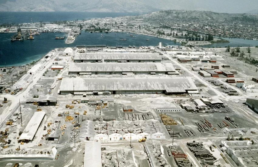
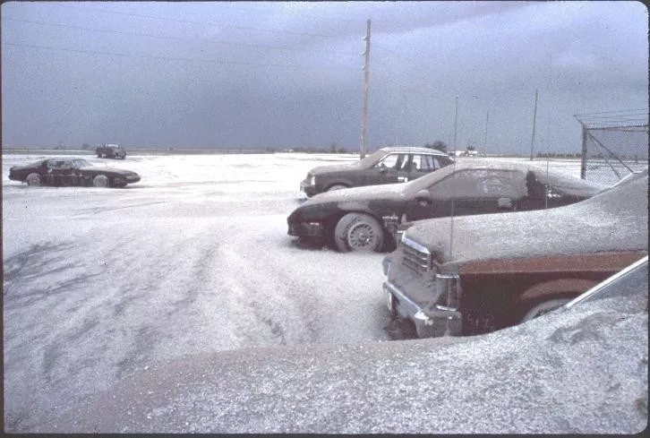
A: As we pulled up pierside, it was an eerie experience. The ash had been accumulating over several days, so they had swept most of the roofs and taken road construction equipment and plowed the roads, much like you would plow the roads for snow. I'm from upstate New York, and when I was a kid, I'd look out my bedroom window and see snowbanks all the way down the street. It wasn't a nice bright white snowbank, but it looked much a typical winter scene after a real heavy snowfall. The volcanic ash was dull gray with some brown, and some of the roofs still had significant ash accumulation on top of them.
Q: What were the cascading dangers that Typhoon Yunya brought?
A: Yunya created a real humanitarian disaster. Much of the area around there became totally uninhabitable, so many local inhabitants who could evacuate had gone to other parts of the island. The rainfall was so heavy, however, that the night before we arrived, a large group of people who remained had sheltered in a gymnasium for protection from the hurricane. Once saturated, several feet of ash on the roof became like heavy concrete, and the roof collapsed. There were a significant number of fatalities from that. In addition, there were many structural failures off base due to the weight of the ash on buildings. The combined effect of the water and the ash was devastating.
Q: Tell us more about the evacuation.
A: The evacuation was all of the military families from the Subic Bay Naval Station, Cubi Point Air Station, and Clark Air Force Base. Some of the military was redeployed to other areas, but the civilian dependents who couldn't get out on their own, had to be evacuated by us. We embarked many of these families on board the aircraft carrier and made two trips from Subic Bay south to the island of Cebu, where the Air Force was flying large transport aircraft out from an old airstrip left over from World War II.
We were taking thousands of people. Interestingly, people come with a lot of stuff, including pets! Down in the hangar bay, there are tie-down spots in the deck every 10 feet or so to secure aircraft. Many now had a dog carrier, cat carrier, or birdcage attached. The U.S. government is very supportive of military families and their dependents, so their pets were also taken on board. People had to go down periodically to comfort, feed, and clean up after them. In addition to a very unhappy Doberman giving birth to a litter of puppies under some yellow gear (aircraft tows), at least one other unusual situation also stuck with me. There were some local people who had been potentially stranded, and it appeared that a few hastily arranged marriages may have occurred. I recall a distraught young lady searching for her husband, and she didn't know his last name! There was no alternative but to get on the intercom like they do when a child wanders off in a department store to ask for a young newlywed named “Ricky” to please report to the quarterdeck because his wife was frantically searching for him.
Q: Even with the success of the evacuations, there were still fatalities. The eruption disproportionately impacted the native Aeta, a small aboriginal tribe that numbered about 60,000 before the eruption. What can we do to protect the most vulnerable populations from events such as this?
A: In the more developed world, you can improve infrastructure, right? You don't always have those options in a lot of developing countries. So, the best you can do, I think, is to provide as much assistance is as you can both technically and on a humanitarian basis. The USGS has a Volcano Disaster Assistance Program (VDAP), which is one of our primary collaborators through the Disasters Program. They provide warnings and assessments in the event of a potential eruption or after one has occurred. In the US., the National Institute of Standards and Technology (NIST) has a group that works on building codes. They work closely with the insurance industry. There are parallels in the international community with the reinsurance industry working with different technical and engineering groups to provide consulting to improve infrastructure resilience and resistance to the impacts of things like volcanic eruptions–but more often for earthquakes, hurricanes and floods.
On the humanitarian side, NASA collaborates with a lot of different humanitarian organizations ranging from the Red Cross, FEMA (the Federal Emergency Management Agency, NOAA (the National Oceanic and Atmospheric Administration) the National Weather Service (NWS), National Guard units, the U.N. (United Nations), CEPREDENAC (the Coordination Center for Disaster Prevention in Central America and the Dominican Republic) and many, many other local, state, federal and international institutions to protect communities across the globe throughout the disasters cycle. Just this month, I’d note NASA’s role and support in the establishment of the newest volcano research supersite in Nicaragua, which will increase the region’s access to Earth observation data.
Q: In your role at NASA today, you are at the cutting-edge of volcano research technology. If the folks dealing with Mt. Pinatubo’s eruption in 1991 could have access to today's monitoring equipment back then, what–in your personal opinion–do you think they would wish for most?
A: I really think that the remote sensing capabilities we have from space are the big game-changer these days. Ground-based monitoring hasn’t changed all that much, although the technology is better. Obviously, communication is faster. We had extremely low-capacity communications lines compared to today. The big changes between now and then are instantaneous broadband communications via the internet and satellite remote sensing, primarily via radar sensors. We also didn't have the benefit of sophisticated plume trajectory models like NASA's Disasters Team uses today, such as NOAA's HYSPLIT model and the Langley Trajectory Model (LaTM).
When I was looking at Pinatubo imagery (in 1991), the area was tropical, and there was a lot of convection. It was tough to distinguish between the regular and ash clouds with the naked eye, so we had to be extra conservative. We couldn't take the risk if we couldn't tell the difference between ash, water and ice clouds. So, we had thousands of square kilometers of warning area in which ash was only a fraction of that area. Fast forward to 2007, work with the University of Wisconsin supported by NASA's Applied Sciences Program helped to improve our ability to differentiate between ash and ice clouds. So, now people can go in and look at multi-channel spectroscopy and very easily differentiate between the ash and the water clouds. The International Civil Aviation Organization (ICAO), an agency of the United Nations, has also set up a worldwide network of Volcanic Ash Advisory Centers, or VAACS, since the time of the Pinatubo eruption. I'm pleased to say that type of information (differentiating between ash and ice clouds) has been incorporated into the warnings that the VAACs provide.
Q: What other resources does NASA provide now to help people understand and make informed decisions about volcanos with increased confidence?
A: When you look at NASA, you must realize that we are a research agency. We don't have the same responsibilities as those who actually have to provide a forecast or have a statutory responsibility like NOAA for weather, or the USGS for geological information and hydrological information. What we really offer is information that fills critical gaps in technology and in science knowledge. Much of what we have is experimental in nature. Clearly, we have high confidence in many of the things that we produce because we understand the underlying science behind it. We're able to add value and insights based on cutting-edge technologies that may be under development and not yet part of the normal warning process. Our website and the Disasters Mapping Portal are good places to see how people use NASA products to inform disaster risk reduction and response.
Q: Considering the next 30 years, what do you anticipate will be the next major innovation in volcanology research?
A: The launch of more Synthetic Aperture Radar satellites, such as the upcoming NASA/ISRO SAR (NISAR) mission scheduled to launch in January 2023, will be a game-changer. I could see hints of this advance in our NASA Disasters Program's recent use of the Japanese Space Agency's ALOS-2 satellite in monitoring the lava dome expansion of LaSoufrière volcano on the Caribbean Island of St. Vincent. We did this for several months before its eruption this past April. Increasing the frequency and number of observations like this may also aid the development of prediction models, which currently are only used for research purposes because they do not yet accurately predict the time or magnitude of an eruption. I'm also excited about the increasing involvement of the commercial sector in space, which will hopefully make observations such as these and others more ubiquitous in the future.
Q: What else comes to mind when reflecting on the significance of the Mt. Pinatubo eruption?
A: Everyone always thinks about the proximate spatial and temporal impacts of major eruptions, but in the long term, understanding the impact of volcanoes on climate change is another important aspect. Average global temperatures are normally cooler after significant eruptions because less solar radiation reaches the lower atmosphere in their aftermath. Sulfate aerosols a from the eruption plume ejected into the stratosphere and stayed there for more than five years. NASA’s Langley Research Center, where I’m based, played a key role in monitoring that using data from SAGE II. Mt. Pinatubo had a significant impact on ozone loss in the stratosphere and is the only major eruption we have on record showing the climate impacts of volcanoes. (Editor’s note: Because of the sunlight-absorbing effect of the aerosols in the stratosphere, scientists measured a drop in the average global temperature of about 1 degree F [0.6 degrees C] over the 15 months following the eruption.)
Q: What final thoughts would you like to share with us?
A: Major eruptions generate public awareness of various societal vulnerabilities and other impacts, even climate change. They are often what motivates policymakers to engage the science community to redouble its efforts to close critical knowledge gaps to help understand, mitigate or prevent impacts of future events. However, it is essential not to wait for an imminent eruption to put focus on volcano research. It is always important to continue to strive to improve our science capabilities to observe, forecast, assess, respond, recover and reduce the risk for disasters.


