Identifying key biodiversity areas is crucial to understanding how endangered species populations react to changes in climate and urbanization. The project focuses on the fluctuations in occupied and available tiger (Panthera tigris) habitat in relation to key biodiversity areas (KBAs), developing procedures applicable to many other species. Integrated datasets of available (but empty) and occupied tiger habitat are being analyzed from 2000 – 2020 and will continue indefinitely into the future. The results are being integrated with simultaneous IUCN Red List and Green Status Assessments for the tiger and in negotiations leading up to the Global Tiger Summit in 2020 in Vladivostock, Russia.
This project addresses Sustainable Development Goal (SDG) indicator 15.1.2 by utilizing in-situ and Earth Observation data to create a near-real time mapping and reporting system for tiger range states including Indonesia, Thailand, Russia, Bhutan, Nepal, India, Bangladesh, Myanmar, Malaysia, and China. It also maps potential reintroduction sites across Southeast and Central Asia where tigers has been extirpated.
OUTPUTS & IMPACT
Creation of the Tiger Conservation Landscape (TCL 3.0) model for use by the international wildlife conservation community (SDG 15.1.2)
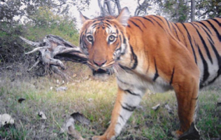
TCL 3.0 includes a model that maps the structural habitats of tigers, with an emphasis on forest canopy height, derived from Landsat data. Additionally, a human footprint model is included, which identifies areas tigers are unlikely to be present due to human impact and intervention. An important aspect of the human footprint model is mapping the degree of tolerance for human-wildlife interactions. In locations with a higher human footprint like India, humans and tigers are more tolerant of each other, and this metric is constantly changing across the tiger range states. Camera traps help identify tiger locations in India (Figure 1).
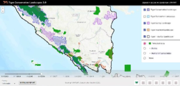
TCL 3.0 integrates historical tiger presence data, structural habitat data, human footprint data, as well as in-situ camera and sighting data, to create a grid-based map of tiger movements over a 20 year period (Figure 2). The team initially implemented TCL 3.0 methodologies and models in Sumatra and the Russian Far East with simulated data but are continuing to expand the geographic range of the model. A model like the TCL 3.0 helps streamline the process of reporting on SDGs and endangered species populations.
Creation of the Tiger Input Portal (TIP) and the Tiger Output Portal (TOP) for use by the governments of the tiger range state countries (SDG 15.1.2)
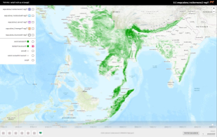
Countries and researchers can upload and integrate field observations to TCL 3.0 through the TIP. These data are typically collected through camera traps, structured surveys, and ad hoc observations. The data can be mapped either by using geographic coordinates, on a more general grid-based map, or as non-location-specific observations. Countries can obtain data for SDG reporting and information about TCL 3.0 through the TOP. The system identifies and maps tiger conservation landscapes, tiger restoration landscapes, tiger survey landscapes, tiger fragments, and source sites (Figure 3). The TOP also maps the overlap of tiger conservation landscapes and key biodiversity areas. The TOP has been integrated into TCL 3.0 and is being used to preserve key biodiversity areas and tiger populations, which relates to SDG 15.1.2.
Related Impact