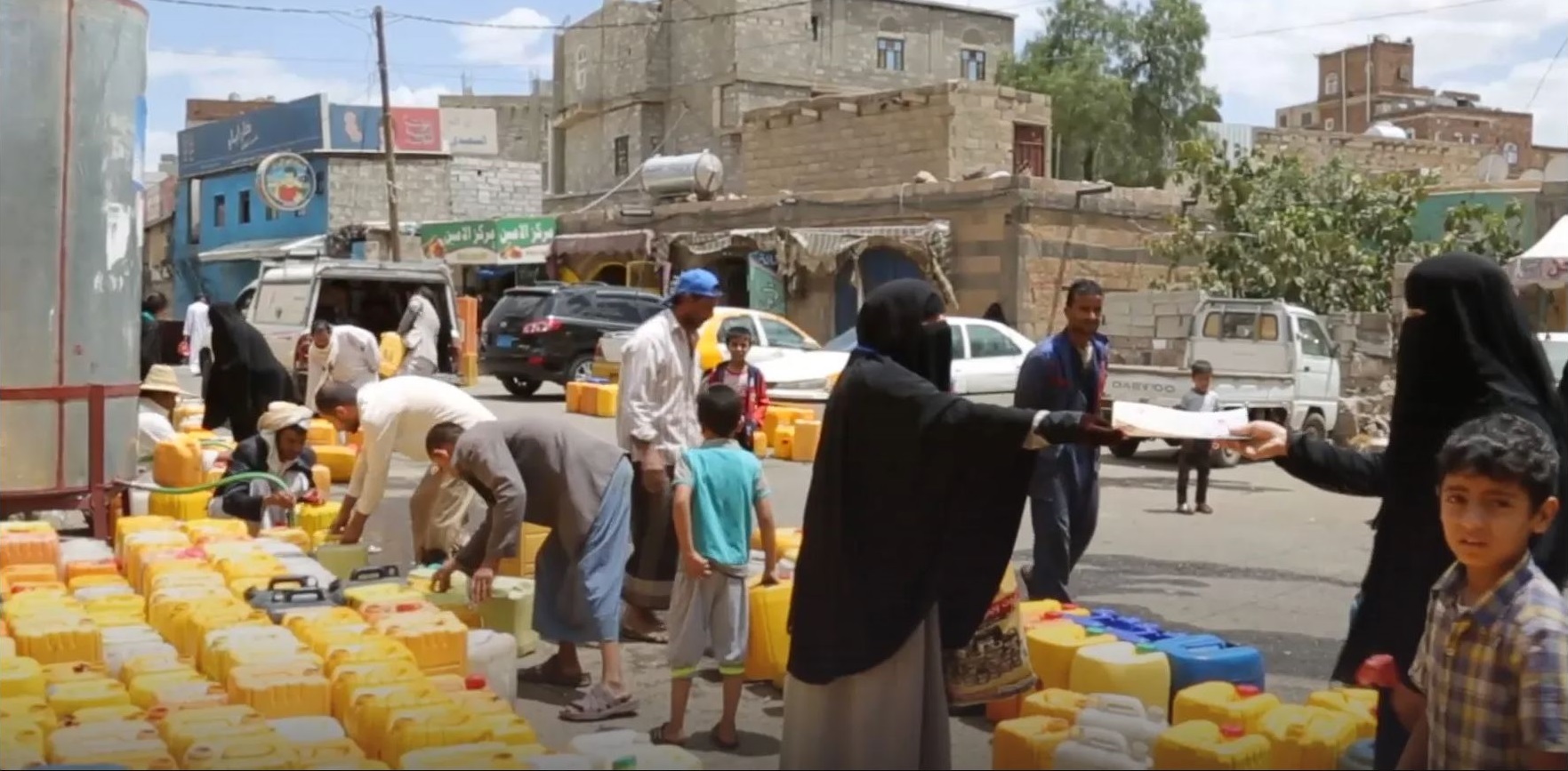
Credit: UNICEF
Since 2018, measurements from NASA Earth-observing satellites have helped to combat potential outbreaks of life-threatening cholera in Yemen and elsewhere around the world. Humanitarian teams have targeted areas identified by a NASA-supported project that precisely forecasted high-risk regions based on environmental conditions observed from space.
“By joining up international expertise with those working on the ground, we have used these sophisticated predictions to help save lives and prevent needless suffering for thousands of Yemenis,” said Charlotte Watts, the chief scientific adviser of the United Kingdom’s Foreign, Commonwealth and Development Office (FCDO).
Cholera is a disease caused by consuming food or water contaminated with the bacterium Vibrio cholerae, which can result in severe diarrhea and death. The disease causes an estimated 1.3 million to 4 million cases each year, across 47 countries, with many cases likely going unreported. Multiple interventions, from coordinated leadership preparedness and response to safe water and sanitation solutions to community engagement, are key to mitigate cholera risk across at-risk communities.
In spring 2018, the British government and international aid groups in Yemen began using the new cholera forecasts to target their work in reducing cholera risk. That work included promoting appropriate hygiene practices to prevent spread of water-borne diseases and distributing hygiene and cholera treatment kits. Project partners have reported that the forecast model fundamentally changes how the international community can address cholera effectively to save lives.
The research on forecasting cholera outbreaks, funded by NASA’s Earth Action Program, is being led by hydrologist and civil engineer Antar Jutla at the University of Florida and microbiologists at the University of Maryland, College Park, Rita Colwell and Anwar Huq, beginning in 1975 and continuing today. This project builds upon their cholera research in Bangladesh.
The NASA forecast tool divides the entire country of Yemen into regions about the size of a typical U.S. county and predicts the risk of cholera outbreaks in each region. To calculate the likelihood of an outbreak, the science team runs a computer model that combines satellite observations of environmental conditions that influence growth and proliferation of V. cholerae with information on sanitation and clean water infrastructure.
The forecast tool employs a variety of NASA satellite observations, including precipitation data from the Global Precipitation Measurement mission, air and ocean temperatures from the Moderate Resolution Imaging Spectroradiometer (MODIS) instruments on NASA’s Terra and Aqua satellites, and measurements of plankton concentrations in nearby coastal ocean areas.
“We have successfully incorporated microbiological data into an environmental monitoring capability built on the discovery that zooplankton, namely copepods, are a significant vector of the cholera bacterium,” Colwell said. “With the ability to employ satellite observations, we now have a powerful public health tool for prevention of cholera pandemics.”
Testing the Cholera Forecast Tool
In 2017, the researchers tested their computer model and found that it achieved 85 to 92 percent accuracy in predicting regions where cholera was most likely to occur and spread in Yemen that year. It even identified inland areas where the population is not usually susceptible to the disease but did suffer outbreaks. The Yemen cholera outbreak was the world's worst in 2017, with more than 1.1 million suspected cases and more than 2,300 deaths, according to the World Health Organization.
International humanitarian organizations took notice. In January 2018, Fergus McBean, a humanitarian adviser with the U.K. FCDO, read an article about the NASA-funded team's 2017 results and contacted them with an ambitious challenge: create and implement a cholera forecasting system for Yemen, in only four months.
“It was a race against the start of rainy season,” McBean said.
The U.S. researchers began working with U.K. Aid, the U.K. Met Office, and the United Nations Children's Fund (UNICEF) on the innovative approach to use the model to inform cholera risk reduction in Yemen.
In March 2018, one month ahead of the rainy season, the U.K.’s FCDO, then known as the Department for International Development, began using the model’s forecasts. Results show the science team’s model predictions, coupled with U.K. Met Office weather forecasts, are helping UNICEF and other aid groups target their response to where support is needed most.
“This groundbreaking initiative is a testament to the importance of interdisciplinary and multi-agency efforts to improve disease preparedness and response,” said John Haynes, program manager for health and air quality applications at NASA Headquarters in Washington.
McBean believes in this new approach. “We are confident acting on the model’s predictions. We know that acting early is a more effective way of operating and is likely to result in a much better outcome for people.”
Going Global
Since 2018, the research team has received NASA funding to expand the cholera model and provide risk maps to national and international health leaders of countries in Africa, Middle East, and other parts of Asia.
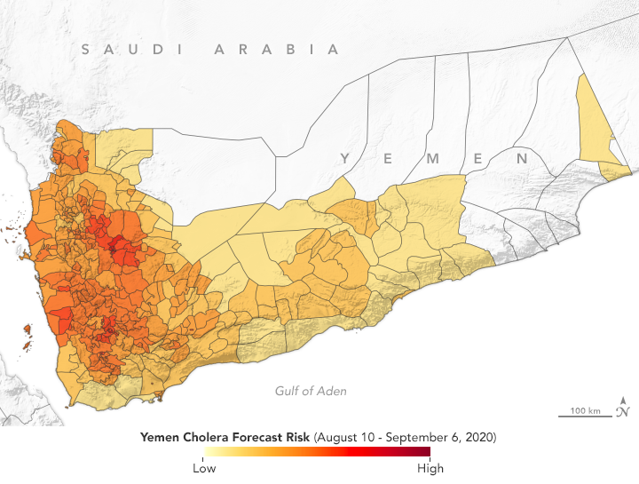
Credit: NASA Earth Observatory / Lauren Dauphin
The team has provided pixel- and county-level risk scores for cholera in Ethiopia, Ghana, Haiti, India, and Sudan, in addition to Yemen. Such scores have also been integrated into health decision-making processes of the project’s partners who conducted situational assessments for Bangladesh, Democratic Republic of Congo, Pakistan, and Ukraine, as requested by the national leadership.
These efforts have allowed the team to connect with additional project partners, including the United Nations Office for the Coordination of Humanitarian Affairs (UNOCHA), the U.K. FCDO, the Red Cross Climate Center, United States Agency for International Development (USAID), and several non-governmental organizations.
A Cholera Prediction Hub tool is currently made available online to the public.
The team is working to prepare a global map on cholera risk, and a decision-making flowchart for geographic areas with higher risk of cholera outbreaks. These efforts ultimately could support the UN Global Task Force on Cholera Control’s Global Roadmap 2030, by providing early information concerning potential cholera outbreaks to national and international decision-makers.
What’s more, the team is also developing an Android-based app linking V. cholerae microbiology, cholera risk assessment, and end-user communication including nearest hospital facility, to provide an on-the-ground tool with relevant information for decision-makers and the public to keep communities healthy.