CALIPSO and CloudSat, two satellites in the newly formed C-Train, captured a stunning overpass through the eye of Typhoon Yutu on October 28th, 2018 at 04:58 UTC as the storm was approaching the Philippines in the West Pacific. Typhoon Yutu contained estimated sustained winds of 120 knots (138 mph) with a minimum pressure of 933 mb, the equivalent of a Category 4 strength storm. At the time of the overpass, Typhoon Yutu was beginning a period of weakening as the storm was moving into less favorable atmospheric conditions, including lower sea surface temperatures. The storm left a trail of destruction through Saipan, Tinian and the Mariana Islands on October 24-25th, 2018 when it was at Category 5 strength.
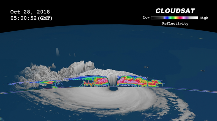
CloudSat's 94 GHz cloud profiling radar (CPR) overpassed directly through the eye of Typhoon Yutu revealing the cirrus-free eye with an outward sloping eyewall, a feature typically found in intense tropical systems. The southern portion of the eyewall appears more disorganized as the thicker cloud tops are starting to disintegrate from the top down. The CPR data reveals the inner details beneath the storm’s cloud tops. Intense areas of convection with moderate to heavy rainfall appear in deep red and pink colors, reaching an estimated altitude of 14 km. A cloud-free area can be seen underneath the northern portion of the cirrus canopy as well. Lower values of reflectivity, in green and blue colors, denote smaller ice and water particle sizes typically located at top of the system (in the anvil area). The CPR signal attenuates in heavy rainfall when cloud droplets become larger than 3 mm and effectively dampen the signal’s strength. This is evident by the lack of signal typically occurring beneath the melting level when frozen particles transform into liquid.

The CALIPSO lidar, also known as Cloud-Aerosol Lidar with Orthogonal Polarization (CALIOP), complements CloudSat radar measurements by observing ice cloud particles at the top of Typhoon Yutu, which are too weak to be seen by the radar. CALIOP data is visualized above as a bluish cross-section, with CPR data superimposed on it. CALIOP measured the top of the typhoon and its accompanying cirrus shield at 15 to 18 km above the ocean surface. The cirrus shield, spanning some 1,200 km horizontally, is comprised of ice crystals formed within the outflow of the typhoon at high altitudes. CALIOP masterfully observes these tenuous ice crystals, shown in grey, red, and yellow in the image. The CPR excels at observing regions where CALIOP cannot penetrate into the densest portions of the typhoon. Together, the CALIPSO and CloudSat observations provide a complete picture of the vertical structure of Typhoon Yutu.


