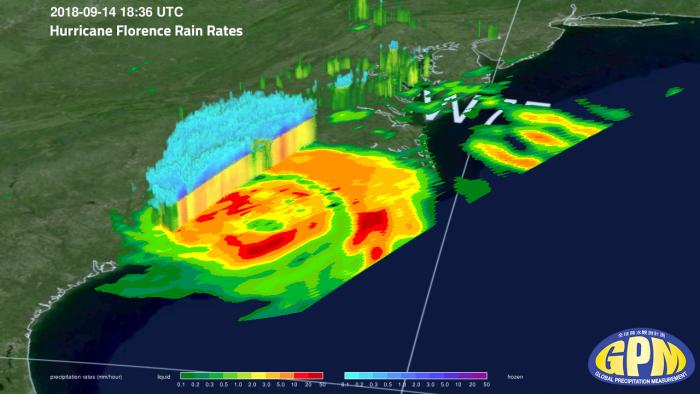
The Global Precipitation Measurement (GPM) mission is an international network of satellites that provide the next-generation global observations of rain and snow. Building upon the success of the Tropical Rainfall Measuring Mission (TRMM), the GPM concept centers on the deployment of a “Core” satellite carrying an advanced radar / radiometer system to measure precipitation from space and serve as a reference standard to unify precipitation measurements from a constellation of research and operational satellites. Through improved measurements of precipitation globally, the GPM mission is helping to advance our understanding of Earth's water and energy cycle, improve forecasting of extreme events that cause natural hazards and disasters, and extend current capabilities in using accurate and timely information of precipitation to directly benefit society. GPM, initiated by NASAand the Japan Aerospace Exploration Agency (JAXA) as a global successor to TRMM, comprises a consortium of international space agencies, including the Centre National d’Études Spatiales (CNES), the Indian Space Research Organization (ISRO), the National Oceanic and Atmospheric Administration(NOAA), the European Organization for the Exploitation of Meteorological Satellites (EUMETSAT), and others.
One of the prime instruments onboard the GPM Core Observatory is called the Dual-frequency Precipitation Radar (DPR). The DPR consists of a Ku-band precipitation radar (KuPR) and a Ka-band precipitation radar (KaPR). The KuPR (13.6 GHz) is an updated version of the highly successful unit flown on the TRMM mission. The KuPR and the KaPR are co-aligned on the GPM spacecraft bus such that that the 5 km footprint location on the earth is the same. Data collected from the KuPR and KaPR units provides 3-dimensional observations of rain and also provides an accurate estimation of rainfall rate to the scientific community.
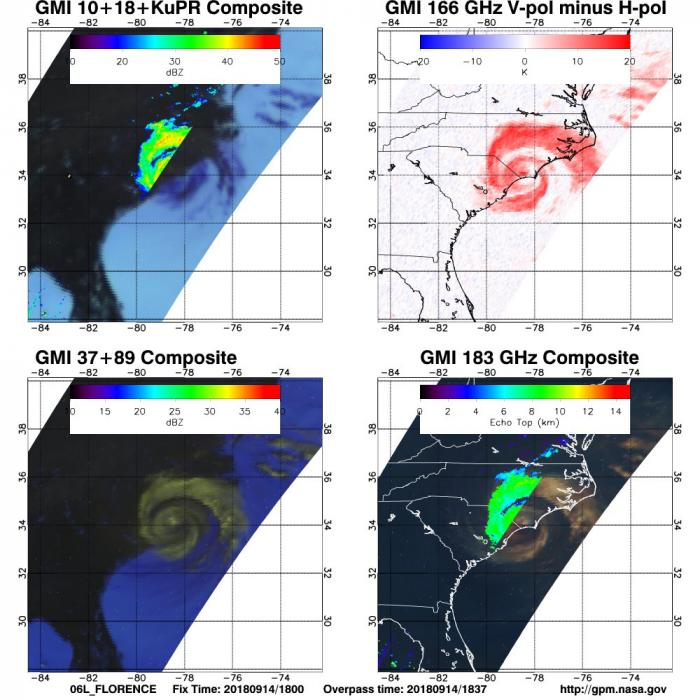
The Global Precipitation Measurement (GPM) Microwave Imager (GMI) instrument is a multi-channel, conical- scanning, microwave radiometer serving an essential role in the near-global-coverage and frequent-revisit-time requirements of GPM. The instrumentation enables the Core spacecraft to serve as both a precipitation standard and as a radiometric standard for the other GPM constellation members.
The GMI is characterized by thirteen microwave channels ranging in frequency from 10 GHz to 183 GHz. In addition to carrying channels similar to those on the Tropical Rainfall Measuring Mission (TRMM) Microwave Imager (TMI), the GMI carries four high frequency, millimeter-wave, channels about 166 GHz and 183 GHz.


