UDPATE 9/26/18:
UAVSAR data from Hurricane Florence is now available on the JPL UAVSAR data webpage. To access this data visit this page: https://uavsar.jpl.nasa.gov/cgi-bin/flight-request.pl?id=18G036 and click the "Data Processed" tab. Alternativly you can visit https://uavsar.jpl.nasa.gov/cgi-bin/data.pl and type "Florence" into the seach box to view data from recent UAVSAR overflights. You can also view these UAVSAR overflights on the NASA Disasters Mapping Portal
Rationale for Remote Sensing of Inundated Landscapes
The southeastern coastal plain is a low elevation and low gradient landscape susceptible to inundation from marine and terrestrial forcing. Hence, flood disasters affecting large and growing communities in these areas arise from the effects of two dimensional flow patterns that typically are very difficult to ascertain. The aim of our research is to determine the dynamics of floods waters, the flood depth versus the areal extent of floods, and how these flood features vary spatially and with rates of water level rise. In flat terrain close to the coast, floods are slow moving and their dynamics cannot be captured by in-situ observations or models but through a combination of these two along with remotely sensed observations. Our studies from Hurricane Harvey using the in-situ observations along with UAVSAR and Sentinel observations showed great promise in the remotely sensed observations as they matched in-situ gage data to a good degree. In this current research we will couple UAVSAR, Sentinel and in-situ observations with Delft-3D hydrodynamic numerical simulations to determine the flow depths in the floodplain of the Congaree, Pee Dee and Waccamaw Rivers. Such work can be use to help with planning for evacuations and to predict how changes in land use affect inundation, inundation flow paths and speed of inundation waters.
Raymond Torres
Venkat Lakshmi
University of South Carolina
UDPATE 9/21/18:
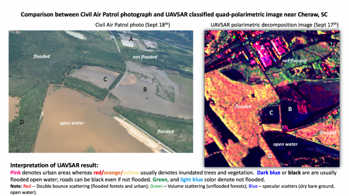
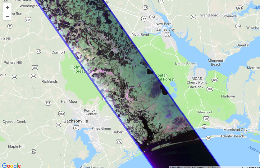
This image compares UAVSAR classified quad-polarimetric imagery near Cheraw, South Carolina on 9/17/18 with Civil Air Patrol photography of the same area from 9/18/18. In the UAVSAR image, pink denotes urban areas whereas red, orange and yellow usually denote inundated trees and vegetation. Dark blue or black are are usually flooded open water; roads can be black even if not flooded. Green, and light blue colors denote non-flooded areas.
UPDATE 9/14/18:
Hurricane Florence’s storm surge and heavy inland rainfall will impact coastal barrier islands and produce widespread riverine and flash flooding, which is challenging to observe through optical remote sensing due to extensive cloud cover, and at publicly available Synthetic Aperture Radar (SAR) wavelengths due to widespread vegetation. This is particularly important at the urban-suburban interface where vegetation may obscure impacts to people in their communities. While streamflow models provide some insights into flood extent through stream gauges, depth grids, and other outputs, Uninhabited Aerial Vehicle Synthetic Aperture Radar (UAVSAR) imagery provides a unique and valuable opportunity to map actual floodwater extent to provide 1) validation to these physical models 2) opportunities to improve them 3) new data sets in challenging complex terrain and vegetation where flood monitoring from SAR needs continuous improvement and 4) near real-time and/or reduced latency use of the imagery to support disaster response and recovery. UAVSAR imagery collected for this event will meet these complementary objectives while benefiting local, state and federal partners in the affected states.
Barrier islands and the immediate coastlines will bear the brunt of the storm surge and hours of tropical storm and hurricane-force winds, leading to potential change in barrier islands and destruction of property along the coastline. Collection of UAVSAR imagery will help to clarify where barrier islands and the coastline have been impacted. Furthermore, rapid acquisition of UAVSAR imagery of damaged homes and infrastructure provides higher spatial resolution details to complement “damage proxy maps” and other change detection approaches applied from routinely collected imagery or special collections from international partners. NOAA and other agencies will fly complementary aerial photography to help document change for correlation to signals obtained at the wavelengths of UAVSAR (L-Band, polarized) and other assets on orbit. This will provide 1) scientific opportunity to better understand signals observed in UAVSAR and complementary SAR imagery as they relate to surface change and structural damage 2) opportunities to further develop change/damage products and mapping from UAVSAR and other on-orbit platforms and 3) share UAVSAR imagery in near real-time or reduced latency for local, state, and federal benefits to the immediate needs of response and recovery.
UAVSAR will complement other SAR instruments on orbit in the study of landslide and debris flow hazards in the complex topography and vegetation of the Carolinas. Ranging from the “Low Country” to the spine of Appalachia, the impacted states experience a range of hazards from flooding to debris flows and landslides. While many of these debris flows and landslides may be relatively shallow and best suited for mapping by high resolution optical imagery post-event, the collection of high spatial resolution UAVSAR data will provide scientists an opportunity to assess the value of UAVSAR information by rapidly mapping these types of impacts while also capturing inland flooding in river valleys, changes in vegetation and other impacts resulting from the storm.
UAVSAR collections will support a NASA Established Program to Stimulate Competitive Research (EPSCoR) funded activity to scientists in South Carolina who are interested in using airborne radar to measure the temporal and spatial variability of free water surface elevation over an inundated flood plain in South Carolina. The observations from the aircraft will be used to test hypotheses using the DELFT-3D hydraulic modeling system. This is another example of UAVSAR collections supporting the validation of physical/hydrological models in their ability to appropriately capture the combined impacts of heavy rain, surge, and other aspects of flooding as a result of natural hazards while also providing impactful data to response and recovery efforts. Furthermore, improved capabilities through validated models may help communities prepare for and mitigate similar events in the future.


