In summer and early fall, beachgoers and residents along the Gulf of Mexico coastline can experience an unpleasant and, at worst, debilitating aquatic annoyance: a dangerous red tide caused by the dinoflagellate Karenia brevis. Toxins released from K. brevis kill countless fish and marine mammals. As those toxins became airborne, beachgoers and community residents may report respiratory difficulties — especially those with severe allergies and asthma.
Now, Floridians looking to avoid the hazardous effects of toxic red tides along southwest Florida beaches — originally in Pinellas County and now in Manatee, Sarasota, Lee, and Collier Counties — have a smartphone-based information resource, with respiratory forecasts updated every three hours, to help them know the risks before they head to the beach.
The blooms and their respiratory impacts are patchy in nature, often affecting one beach but have no impact on an adjacent beach. In addition, cell counts for K. brevis samples are typically completed manually by a technician using a laboratory microscope. The counts can take up to one week to complete, and by the time the results are made available to the public, the information is outdated.
Richard Stumpf, a NOAA oceanographer, led a NASA-funded study, which aimed to provide timely information to Florida beachgoers and residents about which beaches are safe to visit. His team partnered with the United States Integrated Ocean Observing System Gulf of Mexico Coastal Ocean Observing System (GCOOS), the Florida Fish and Wildlife Conservation Commission, and the Pinellas County Environmental Management to develop a red tide respiratory forecast that is updated every three hours.
"This 24-hour Experimental Red Tide Respiratory Forecast lets people see which beaches might be impacted by red tide, allowing them to plan their beach activities. They can use this tool the same way they use other weather reports,” said Barbara Kirkpatrick of GCOOS.
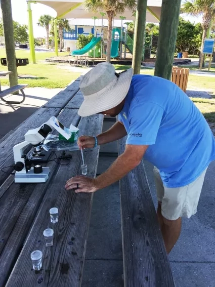
To understand the extent and evolution of fast-changing blooms around the world — a key research objective of NASA’s Earth science program — satellite observations are essential. Data from NASA’s Terra and Aqua spacecraft and the European Space Agency’s Sentinel-3 satellites were used to develop the system. These satellites provide data that guide ground sampling locations, which are fundamental to identifying the toxic organisms and help fill in any gaps in sampling. The Pinellas County Environmental Management team conducted a daily direct counting of K. brevis and then analyzed on-the-ground coastline data collected through the HABscope.
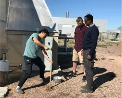
Using this smartphone-accessible forecast developed by project partners including NOAA, GCOOS, and other institutions, citizen scientists or community members who were trained for project data collection collected videos of water using microscopes attached to their smartphones. The videos were then uploaded to a cloud-based server and were automatically analyzed by computer software developed by GCOOS that identifies and counts the number of K. brevis cells in the water sample.
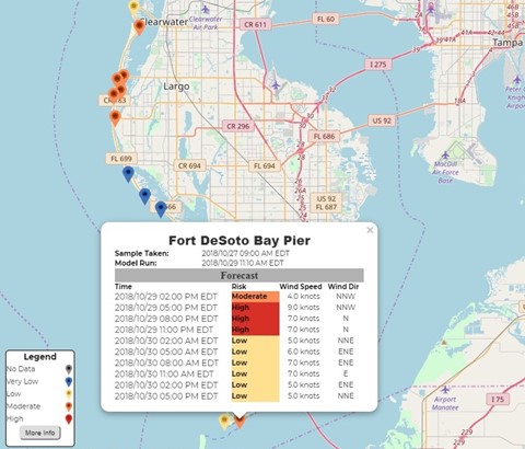
This experimental forecast was tested first in Pinellas County in 2018, because the county had rapidly developed a robust data collection system for red tide cell counts. This cell count data, combined with wind forecast information, helped verify the beach-level forecast models.
“Now, thanks to the water testing conducted by Pinellas County, we're able to refine our forecasts and offer predictions on a beach-by-beach basis,” Stumpf said. “This forecast is the first step toward reducing the health and economic impacts of red tides for coastal communities. No one should get sick from a day at the beach.”
The goal behind creating this tool was to improve red tide forecasting from county-scale coverage down to the beach level in Florida, expanding access beyond state-level data. These forecasts have been widely distributed using National Weather Service notification networks. The accessibility of HABscope — both from a financial standpoint and from an ease-of-use standpoint — allowed scientists to reach their project goal.
After the project finalized in 2019, this team obtained additional NOAA funding to establish a sustainable volunteer network of citizen scientists as well as make enhancements to the HABscope and the respiratory model for long-term sustainability. In 2021, NOAA committed to long-term sustainability of this operational automated monitoring and forecasting capability across Florida with expansion to Texas.