Fans of the Volunteer State sing its praises from the Grand Ole Opry to Beale Street. Tennessee is home to 54 state parks, including the beautiful Great Smoky Mountains, which straddle the border between Tennessee and North Carolina.
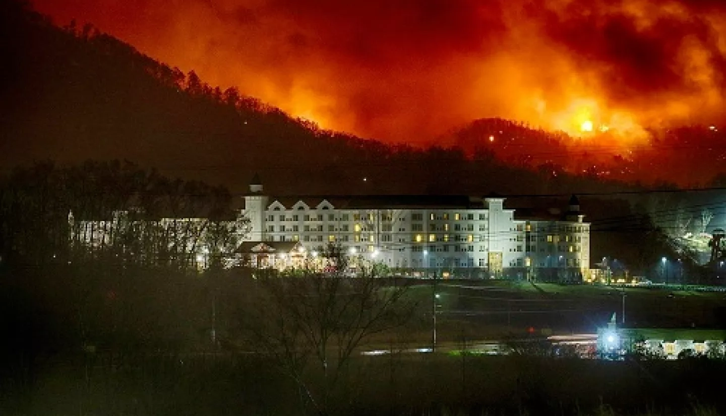
In the fall of 2016, however, tragedy struck the Great Smoky Mountains – and much of eastern Tennessee – as numerous wildfires ravaged the region. These fires were part of a much larger complex of wildfires that broke out across 7 states in the southeastern United States. One of the largest and deadliest wildfires was the Chimney Tops 2 fire.
It ignited in Great Smoky Mountains National Park and merged with other local wildfires, eventually spreading into Gatlinburg, Tennessee and burning over 10,000 acres. By the time it was contained, the blaze had claimed more than a dozen lives and burned thousands of buildings in the Gatlinburg area.
As devastating as 2016 was, Joe O’Brien of the U.S. Forest Service (USFS) pointed out that wildfires have structured the landscape of southern Appalachia throughout its history.“It's evolved with fire; fire is an integral component of the ecological functioning,” he said. “It's also a densely populated region in the United States, so we have an intersection of landscapes that need fire, combined with a population that might be sensitive to fire … It's very complex.”
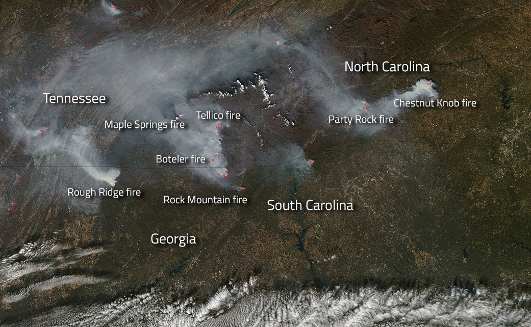
One year after the 2016 wildfires, a DEVELOP project within NASA’s Earth Applied Sciences Program partnered with USFS to see how Earth-observing data could help the agency better manage this complexity. For this project, a University of Georgia-based DEVELOP team focused on a swath of the southern Appalachian region around the national park – which included parts of Tennessee, North Carolina and Georgia.
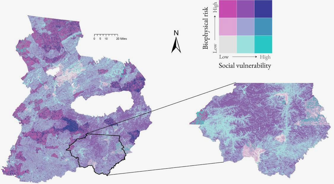
“The team tapped into NASA satellite data to assess the severity of the wildfires by comparing before and after images of the 2016 fires,” said DEVELOP’s Amanda Aragon. By mapping the local geography and comparing the changes in landcover and vegetation health, the team determined which areas of the study region were at the highest risk for wildfires.
For project partner Steve Norman of the USFS Southern Research Station, this risk assessment provided the agency with a critical resource. “Risk assessments provide formal ways to integrate the value we get from forests and adjacent communities with the chance of loss due to some threat, such as wildfire,” he explained. “There’s no way for us to know if and when a wildfire will happen with 100% confidence, however [with a risk assessment], we can address its chance or likelihood based on our understanding of how wildfire has occurred in the past and how it behaves.”
The DEVELOP team reviewed the demographic data of the region to determine which communities were most vulnerable to wildfires. Some of the social variables the team examined were a community’s preparedness level, its ability to recover from a disaster, and its amount of under-managed land.
“Managers and planners need information that is as current as it can be … and satellite data is unmatched in its ability to provide that service.”
–Steve Norman, U.S. Forest Service
“[The results] gave us valuable insight,” said DEVELOP’s Austin Stone. “For example, areas near highly urban Knoxville, Tennessee are less vulnerable than communities in rural areas near the Great Smoky Mountains National Park. These results are geared to help inform communities about their status of vulnerability, and [help encourage] strategies for minimizing risk.”
The team used these results to create a detailed map showing where the region’s natural wildfire risk and social vulnerability overlapped. Norman emphasized that this gave USFS a broader and more cohesive understanding of which locations were most susceptible to wildfires. “[This] knowledge can provide powerful insights for prioritizing fuel treatment or fire prevention efforts, planning for new developments, and improving wildfire response.”
Norman also added that receiving data from the vantage point of space is invaluable to the Southern Research Station, especially as the agency focuses on the future of its wildfire efforts. “The best part of satellite-based maps is how easily they can be updated,” he remarked. “Where fires become more common – and as homes expand into the forests of our region – managers and planners need information that is as current as it can be … and satellite data is unmatched in its ability to provide that service.”


