Increasing temperatures, as well as more severe and frequent droughts and fires, has led to recruitment failure in semi-arid forests in the western US. The project team analyzes satellite Earth observations and climate factors to identify optimal reforestation sites. Since recruitment failure affects semi-arid forests across the world, this project’s outputs can be applicable globally. This project addresses Sustainable Development Goal 15 (Life on Land) by utilizing Earth Observation data to create a reforestation decision support system.
OUTPUTS & IMPACT
Creation of a web-based decision support system for use by US forest resource managers (SDG 15.1, 15.2, 15.1.1, & 15.2.1)
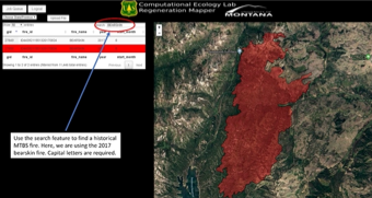
A prototype of the system has been developed to provide grid-based spatial information and predictions about the potential for natural regeneration in a specific post-fire environment (Figure 1). Users can either upload a custom burn map for a potential reforestation site or select a historical wildfire site to examine. The system also provides a cost-benefit analysis feature to help identify optimal replanting areas. The potential for natural regeneration is determined by the distance to adult live trees which serve as seed sources, as well as historical climate conditions and responses. The system simulates Potential Land Surface Temperature (P-LST) and dynamic stress index (DSI) based on percent loss of conductivity in plants. System outputs are mapped over areas where reforestation is mandated due to the National Forest management Act (NFMA). The tool outputs can help inform SDG-related decisions about forest resiliency and adaptability.
Integration and expansion of eco-hydrologic model (Ech2o) into the decision support system (SDG 15.1, 15.2, 15.1.1, & 15.2.1)
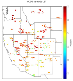
One of the key components of the decision support system is the integration of the Ech2o model with a plant hydraulics model. Ech2o considers energy balance in relation to hydrologic and forest growth data. The project team calibrated the Ech2o model using daily time-series of mean-field soil moisture as well as streamflow measurements from USGS to optimize against. This process allowed for predictions to be made about water dynamics and soil moisture measurements in crucial replanting areas. After running simulations, the model parameters adjusted accordingly to maximize efficiency within the decision support system. Figures 2 and 3 illustrate how the P-LST data is mapped and examined alongside MODIS data. USFS forest resource managers utilize these outputs for SDG-related contributions and climate issues.

Creation of future climate simulation models for use by US forest resource managers (SDG 15.1, 15.2, & 15.2.1)
After discussion with USFS scientists and partners, it was decided that the most useful timeframe for climate prediction models is 2030 through 2050 because of the relevance to current forest management and planning challenges. The models use daily and sub-daily inputs to report on average changes in minimum temperatures, maximum temperatures, solar radiation, and precipitation. A stochastic weather simulator is used alongside three global climate models to host and integrate the climate data as well as predict future changes. This information is relevant to predicting SDG-related changes in climate, thus helping to inform SDG climate policy decisions.