
Start Date: Oct. 28, 2025
Type:Hurricanes & Cyclones
Region: Caribbean, North America
View maps and data on the NASA Disasters Portal
UPDATE NOV. 17, 2025
Hurricane Melissa made landfall in western Jamaica on Oct. 28 as a historic Category 5 storm – the strongest ever recorded in the country. With sustained winds near 185 mph, the hurricane caused severe damage across the island, destroying homes, flattening crops, triggering landslides, and driving significant coastal flooding. Power and communications were knocked out across wide areas, and debris blocked major roads, isolating several communities. Early assessments estimate billions in damage, with extensive impacts to housing, agriculture, and critical infrastructure.
In response, the NASA Disasters Program’s Disasters Response Coordination System (DRCS) activated to support Jamaica’s emergency operations. Working with the U.S. State Department’s International Disaster Response office, the U.S. Geological Survey, Jamaica’s National Spatial Data Management Branch, and the nonprofit GiveDirectly, NASA provided satellite-based products to aid response and recovery, sharing them directly with stakeholders as well as on the NASA Disasters Portal.
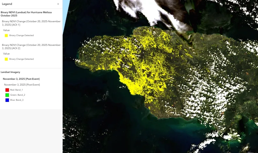
Jamaica’s National Spatial Data Management Branch shared NASA Disasters Program datasets with stakeholders in the forestry department and electric utilities to help assess damage and other storm impacts. Maps derived from NASA Black Marble nighttime-lights data highlighted regions potentially experiencing power outages, while Normalized Difference Vegetation Index (NDVI) maps – produced from near-infrared NASA/USGS Landsat and commercial Planet Labs imagery – helped assess the widespread damage to croplands and forested areas.
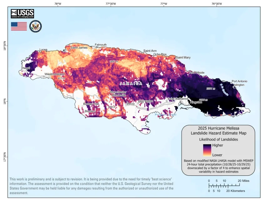
NASA also collaborated closely with the U.S. Geological Survey (USGS) to help assess landslide hazards in Jamaica. The NASA DRCS team shared a landslide proxy heat map with USGS and other partners, and scientists from NASA’s Goddard Space Flight Center worked with the USGS’s Landslide Hazards Program to integrate NASA’s Landslide Hazard Assessment for Situational Awareness (LHASA) model on USGS servers. This enabled rapid generation and public posting of a landslide hazard estimate map to assess the location and severity of landslides across the island.