Start Date: June 23, 2025
Disaster Types: Fires, Floods, Landslides
Region: North America
View maps and data on the NASA Disasters Mapping Portal.
UPDATE JUNE 25, 2025
The NASA Disasters Program’s Disasters Response Coordination System (DRCS) activated June 23 in response to the Trout Fire and Seven Springs Fire near Silver City and Mescalero, New Mexico respectively. Forecasted storms are expected to raise the risk of flash flooding and landslides across recent burn scars.
At the request of the Federal Emergency Management Agency (FEMA) and the New Mexico Emergency Operations Center, NASA is providing satellite imagery and data to aid search and rescue operations, evacuation planning, and early recovery. Initial products supporting the response include imagery for fire monitoring including True Color and Color Infrared Imagery (from Planet and Sentinel-2) for the Trout Fire, in Grant County, and for Seven Springs, New Mexico and landslide risk modeling using NASA’s Global Landslide Hazard Assessment Model (LHASA).
The DRCS is also evaluating and producing additional products for the region including those that can potentially inform awareness of flood water coverage (inundation), debris forecast and mapping, and anticipated impacts to transportation infrastructure from flooding, landslides, and debris flow.
With storms already moving across the burn areas, the DRCS has released a satellite-based web map that pairs two key layers: dNBR burn-severity scores – derived from before-and-after Landsat / Sentinel-2 images that show how badly vegetation was damaged – and a terrain model that highlights the steepest slopes. By showing watershed boundaries, the map can help responders figure out which buildings, roads, and other infrastructure are downhill from burned hillsides – places most likely to be hit by mudslides or debris flows after heavy rains. Although the map focuses on vegetation burn, it aims to give those on the ground a swift look at the region to assess priority areas for attention, providing a “head start” before in-person surveys can be completed.

This binary map of Northeast of Pinos Altos, New Mexico, produced June 22, 2025, shows areas (yellow) with dramatic sloped and demonstrated difference in Normalized Burn Ratio (NBR) from before and after the event. The yellow areas are susceptible to cascading flood and landslide hazards after regional fires. Some at-risk areas overlap with local roads. The underlying imagery shows a difference from before and after dNBR; burn scars are indicated by lighter areas. Credits: ESA/MSFC (S2), LP DAAC (dNBR)
All six NASA centers comprising the DRCS are providing expertise to support these requests, including Ames Research Center in Silicon Valley, California; Johnson Space Center in Houston; Marshall Space Flight Center in Huntsville, Alabama; Langley Research Center in Hampton, Virginia; Goddard Space Flight Center in Greenbelt, Maryland; and the Jet Propulsion Laboratory in Southern California.
Products supporting the disaster activation are posted in the June 2025 New Mexico Wildfires gallery on the NASA Disasters Mapping Portal. Agencies and organizations needing NASA Disasters Program data products to support response or recovery for this event can also email DRCS@nasa.gov with their requests.

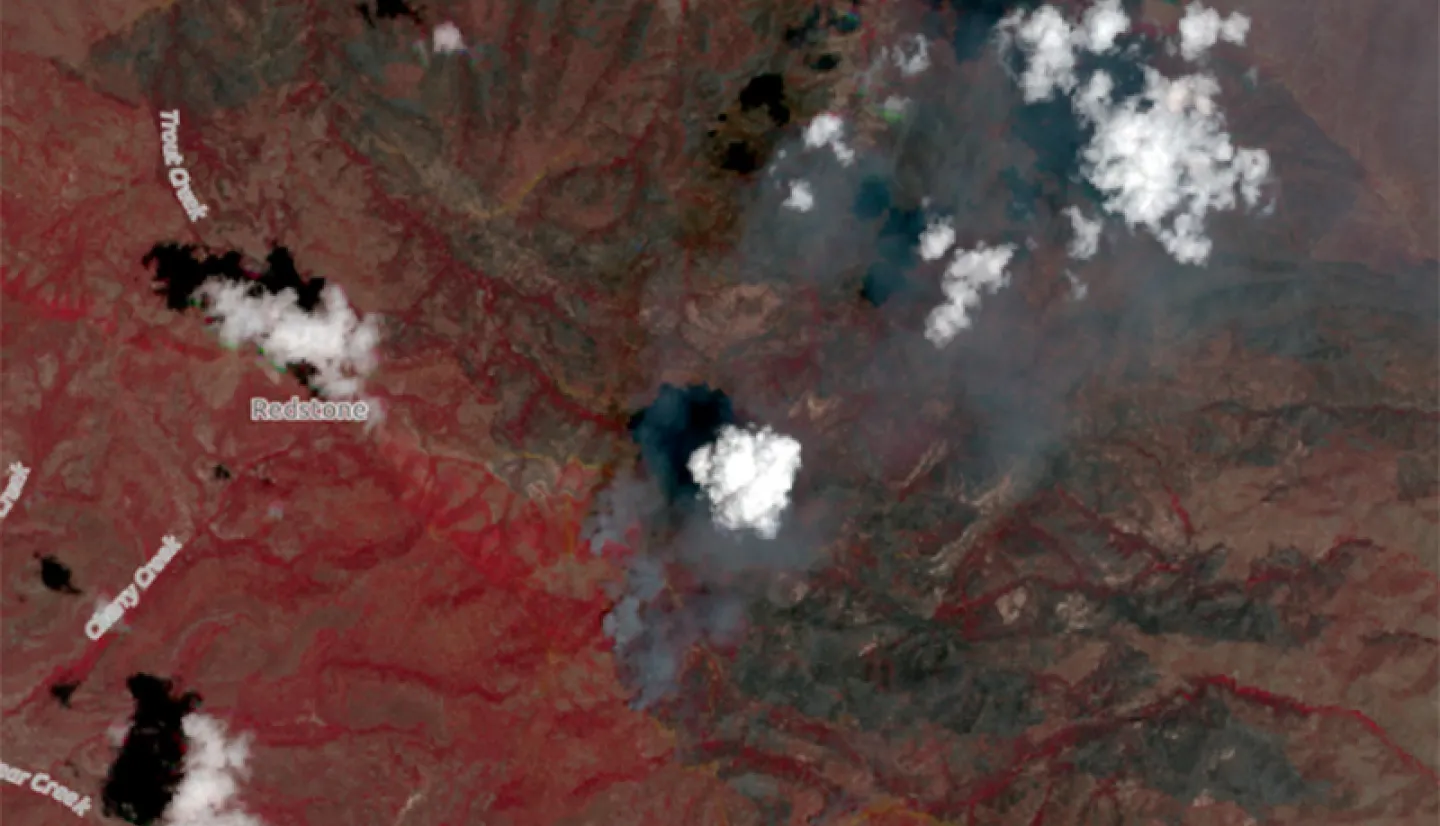
This Planet Scope imagery shows the burned area from the Trout Fire, one of the ongoing wildfires in New Mexico. This Color Infrared composite was created on June 20, 2025, using the near-infrared, red, and green channels, allowing the ability to see areas where vegetation has been damaged by fire. The near-infrared capability provides the ability to see through thin clouds. Healthy vegetation is shown as red, water is in blue, and burn scars appear black or brown. Image acquired through the Commercial Satellite Data Acquisition Program. Credits: NASA Disasters Program. Includes copyrighted material of Planet Labs PBC. All rights reserved.