Start Date: Feb. 19, 2025
Type: Floods, Landslides
Region: North America
View maps and data on the NASA Disasters Mapping Portal
Overview:
The Ohio River Valley has experienced significant flooding due to prolonged heavy rainfall that fell during the 2025 Valentine’s Day weekend, resulting in evacuations, water rescues, landslides, and road closures. The NASA Disasters Response Coordination System (DRCS) has activated and is responding to requests from FEMA Region 4, FEMA's Response Geospatial Office, and NWS Southern Region. The DRCS is sharing products to provide awareness of flooding and landslides across the region and is participating in interagency coordination calls to address evolving needs.
Learn more about how NASA Disasters Program science helps communities manage flood risks.
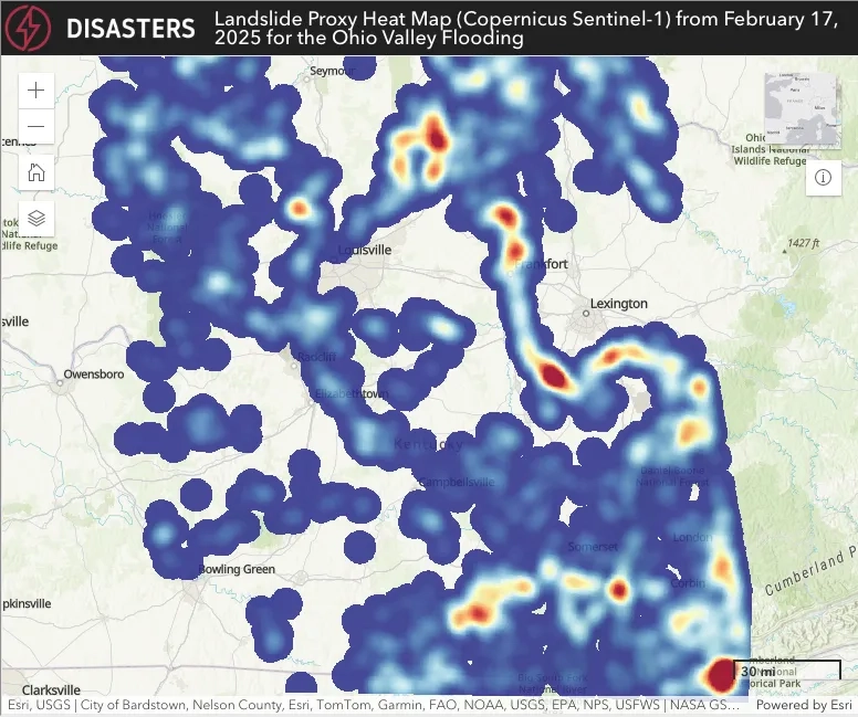
The DRCS created this landslide heat map to aid response partners in identifying areas in the Ohio Valley most likely to experience landslides. This map was generated using Copernicus Sentinel-1 synthetic aperture radar data from before and after the flooding, using a change detection technique with Google Earth Engine. Red and yellow areas indicate a higher probability of landslides, while blue areas indicate lower probability. Credits: NASA GSFC Landslides Team, Copernicus Sentinel-1 data.