
Centered squarely in the southern Great Lakes, Ohio’s northern border abuts more than 300 miles (482 kilometers) of Lake Erie, an invaluable resource for Ohio’s recreation and commerce. Lake Erie also provides drinking water for about 11 million people in the United States and Canada.
So much activity in and around the water, however, makes the lake prone to pollutants, particularly phosphorus, which comes from agricultural fertilizer, manure runoff and wastewater treatment. This excess phosphorus acts as food for tiny cyanobacteria in the lake – also called blue-green algae – which can trigger periodic harmful algal blooms (HABs) that are toxic to people and animals. NASA combined Earth-observing data with NOAA’s Harmful Algal Bloom Bulletin to produce same-day forecasts and four-day forecasts of the position and size of the blooms to help protect public health.
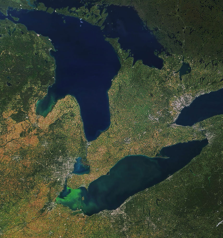
The peak time for HABs is typically during the late summer and early fall, when lake water is warmest. HABs aren’t just dangerous if you swim in or drink the water. Their toxins can become airborne and cause health problems in people living near the shore – especially those with severe allergies and asthma.
To help monitor the threat from HABs, the National Oceanic and Atmospheric Administration (NOAA) regularly issues updates on HABs for several freshwater locations in the United States. NOAA publishes a Harmful Algal Bloom Bulletin forecasting HABs in western Lake Erie, where HABs occur more often due to warmer water and heavier phosphorus loads.
In 2012, a NASA project teamed up with NOAA to add satellite data into the environmental information NOAA uses for its bulletins. NASA satellites can detect the presence of cyanobacteria, and when that information is combined with data on water temperature, wind conditions and currents, it provides forecasters with more accurate monitoring and prediction of HABs.
“Cyanobacterial blooms are readily identifiable with satellites,” explained Richard Stumpf, an oceanographer with NOAA’s National Centers for Coastal Ocean Science who developed the bulletin. “Satellites allow us to detect the [harmful algal] bloom and estimate the amount across the entire lake. Shipboard sampling can only cover a few stations. Satellites also provide more frequent data. For a large lake like Lake Erie, we might get two images in a day.”
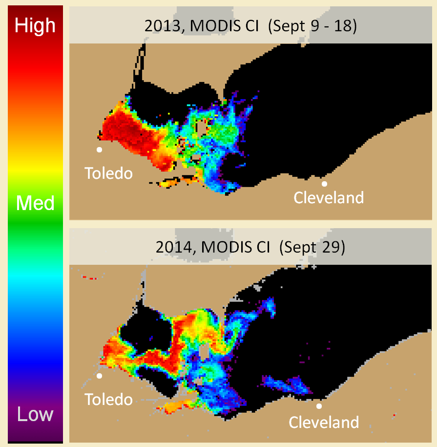
With the addition of NASA Earth observations, NOAA can determine the development, location and forecast positions of HABs more easily and accurately. With this new information, the bulletin started producing both a same-day forecast and a four-day outlook of HABs’ position and bloom size.
The bulletin was particularly useful in late July 2014, when it reported an algal bloom near an intake for the Toledo water supply. By August 1, the bulletin reported a large increase in the bloom’s concentration. Toledo officials collected additional samples, showing that the bloom had overwhelmed treatment and that toxins were in the drinking water. City officials immediately issued a ban on using tap water for half a million residents in and around Toledo. By August 3, city officials had modified their treatment and they lifted the ban – and the state of Ohio requested that bulletin publication increase to twice weekly.
“Satellites allow us to detect the [harmful algal] bloom and estimate the amount across the entire lake. Shipboard sampling can only cover a few stations.”
–Richard Stumpf, NOAA
Less than three weeks later, the bulletin alerted the Ohio Environmental Protection Agency (EPA) about an existing Lake Erie HAB that had expanded eastward and was possibly threatening water systems on Kelleys Island, a popular vacation destination near Sandusky. The Ohio EPA notified managers of the potentially affected water systems, provided guidance on treatment, coordinated sampling, and requested that water systems managers notify the agency if they noticed changes in the water supply.
With successes like these, the bulletin’s popularity as a decision-making guide has jumped in the last few years. According to Stumpf, more than 2,000 people subscribe to the HAB Bulletin email, including “every public water supply operator on Lake Erie, the media, environmental groups, natural resource managers, charter boat captains … and anybody else who is interested.”
This story is part of our Space for U.S. collection. To learn how NASA data are being used in your state, please visit nasa.gov/spaceforus.


