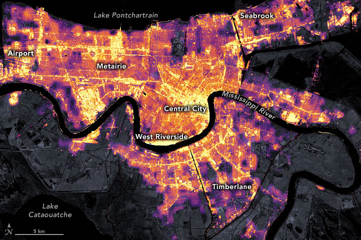
Sixteen years after Hurricane Katrina, Hurricane Ida made landfall in the southern US on August 29, 2021. More than 1 million people lost power. NASA's Black Marble HD helped evaluate the impact of Hurricane Ida on electric grids within the neighborhoods of New Orleans, LA. The baseline image (before the storm) was from August 9, 2021, a cloud-free, moon-free night, and the "after" image was from August 31, 2021, the day after the storm made landfall in the Gulf of Mexico. The images show the widespread loss of electricity access as well as the pockets of the city that had backup power - the central city, airport, and Valero refinery. This comparison between the two images is meant as a visual assessment of outage impacts to aid various partners who are working to deliver emergency aids to local communities. Power outage maps like these help disaster response efforts in the short-term, as well as long-term monitoring in the crucial stages of disaster recovery.
Satellite/Sensor/Resolution: The primary data source utilized in this project is NASA’s Black Marble nighttime lights product suite (VNP46), a product derived from the Visible Infrared Imaging Radiometer Suite (VIIRS) Day/Night Band (DNB) onboard the Suomi National Polar-orbiting Platform (SNPP). Black Marble images are downscaled using high resolution base layers --Landsat derived normalized index products (NDVI and NDWI), which describe the distribution of water and vegetation, and a layer derived from OpenStreetMap (OSM) which describes the distribution of roads. The resolution of the final product is 30 x 30m, and the images are used to visualize how power outages are distributed throughout a city.
Outcomes and Impacts: To elevate public awareness of the product, the team disseminated project results to several news outlets including Earth Observatory, Gizmodo, Science Times, Flowing Data, Tech Times, Copernical, and local New Orleans broadcast meteorologists. The NASA Black Marble team also distributed this analysis and the derived data to stakeholders at FEMA involved in the New Orleans recovery effort. The data is also currently hosted in the NASA Disasters portal for nonprofit response and relief organizations.
EO data used: VIIRS
Link(s) to the data source and/or project:
- NASA’s Black Marble Product Suite
- Román, M.O. et al. (2019) Satellite-based assessment of electricity restoration efforts in Puerto Rico after Hurricane Maria. PLoS One, 14 (6).
- Román, M.O. et al. (2018) NASA’s Black Marble nighttime lights product suite. Remote Sensing of Environment. 210, 113–143.