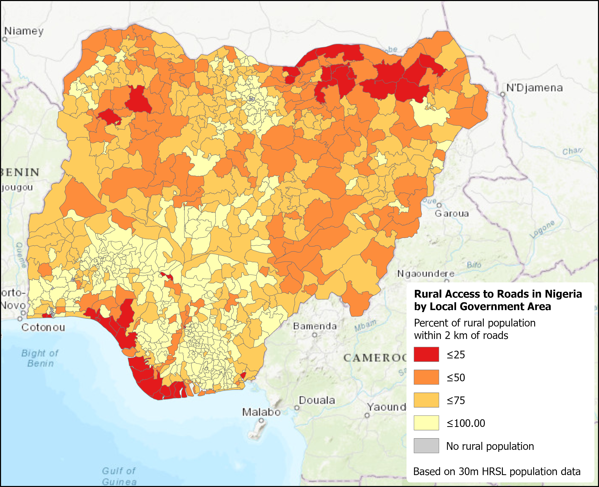
In a world of more frequent weather extremes, evolving climate conditions, large-scale geophysical hazards, devastating conflict and population displacement, and other challenges to sustainable development, knowing where people live and work, and the status and condition of their buildings and other infrastructure, has become increasingly vital. Whether distributing humanitarian aid, planning censuses or public health campaigns, or designing infrastructure improvements, decision makers need better information on how many people need assistance or may be affected, how accessible they are, and what infrastructure may be available in specific areas of interest. Such areas may not coincide with readily available census data or administrative units, so detailed geospatial data are particularly valuable in translating and integrating data into forms useful for decision makers at local, national, regional, and global levels.
This project is part of an overall GEO Human Planet Initiative that is building on the recent growth in data on human settlements, population, and infrastructure, drawing on data from NASA and other sources of Earth Observation (EO) data. In 2015, the international community adopted the 2030 Agenda for Sustainable Development, committing the world to achieving 17 interlinked Sustainable Development Goals (SDGs) by the year 2030. These SDGs cover a wide range of social, economic, environmental, and institutional aspects of development, such as the access that people have to paved or unpaved roads, public transportation, sanitation, clean water, open space, and electricity. In particular, many of the agreed SDG targets and indicators depend greatly on the ability of countries to identify specific population groups in both urban and rural areas that are not making sufficient progress towards meeting particular goals. Relevant EO data include moderate-resolution data from Landsat and Sentinel, night-time lights from the Suomi-NPP satellite, and high-resolution imagery from various commercial sources.
Working with the Joint Research Center (JRC) of the European Community, and with National Statistical Offices (NSOs) and other stakeholder groups in Nigeria, Colombia, and other countries, the project is developing and comparing selected SDG indicators, identifying and supporting local and national indicator needs and assessing uncertainties due to different data sources. The project is also contributing to SDGs Today, an online resource that the United Nations Sustainable Development Solutions Network (SDSN) and Esri produced to provide more current SDG indicator data to support international monitoring and intercomparison. Online training is being provided in collaboration with ARSET, the SDSN’s Thematic Research Network on Data and Statistics (TReNDS), the POPGRID Data Collaborative, the GEO Earth Observations for the Sustainable Development Goals (EO4SDG) initiative, the United Nations Group of Experts on Global Geospatial Information Management (UNGGIM) and other groups. The Center for International Earth Science Information Network (CIESIN) at Columbia University leads the team, along with partners from the University of Louisville and ImageCat, Inc.