NASA Lifelines uses science, technology, and data to empower humanitarian response.
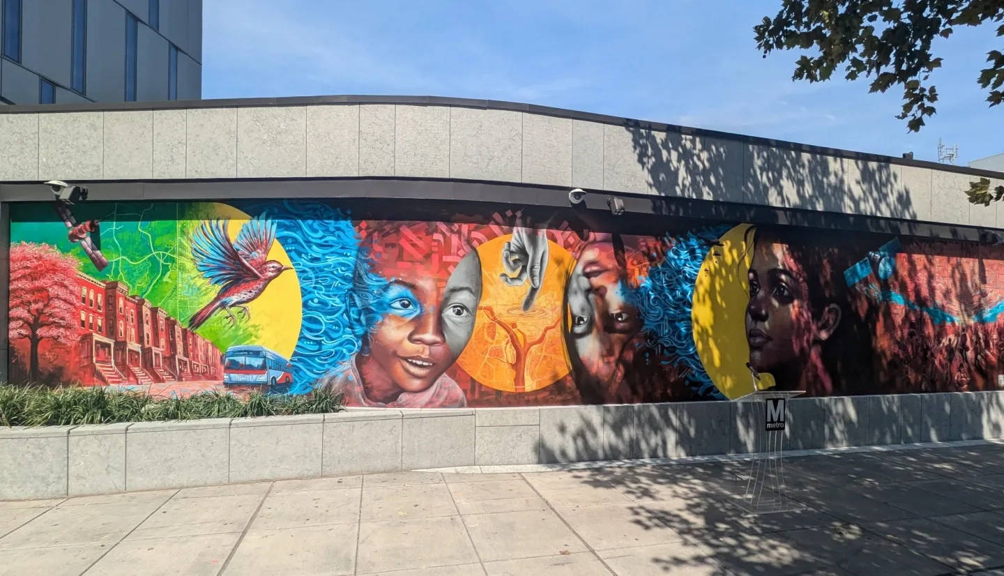
On Aug. 28, 2024, scientists, humanitarians, and city officials gathered at the Washington Metropolitan Area Transit Authority headquarters in Washington, D.C., to celebrate the unveiling of a new mural. The mural aims to raise awareness of how Earth science can empower humanitarian innovations. The D.C. mural, along with others recently unveiled in Nashville, Tennessee, New Orleans, Louisiana and St. Louis, Missouri, was created through NASA Lifelines — an initiative dedicated to building communities that unlock the power of Earth science and technology to improve humanitarian outcomes for communities around the world.

Satellites orbiting Earth collect a wealth of information, including imagery of natural hazards, disasters, crises, and conflicts. This data accumulation is rapidly accelerating, and our ability to analyze it is also growing rapidly. Despite this abundance, valuable insights embedded within this trove of information are often inaccessible to the humanitarian practitioners who need them the most.
Enter NASA Lifelines, a six-year initiative born out of a partnership between NASA’s Earth Science Division and DevGlobal, a services firm that supports organizations worldwide with their innovation and sustainability initiatives. NASA Lifelines is dedicated to unleashing the potential of satellite-derived insights for humanitarian action and is working to build communities that bring Earth scientists and humanitarians together.

Since its launch last fall, NASA Lifelines has engaged over 500 humanitarian practitioners and Earth scientists across 143 countries – including 14 of the 20 on the IRC’s Emergency Watchlist. Through NASA Lifelines, these humanitarians and scientists have pitched their Earth science innovations in Ready for Impact presentations, engaged in cross-cutting conversations at Supper Clubs, and shared technical ideas at Scientist Speed Dating sessions.
Welcome to the NASA Lifelines Galaxy
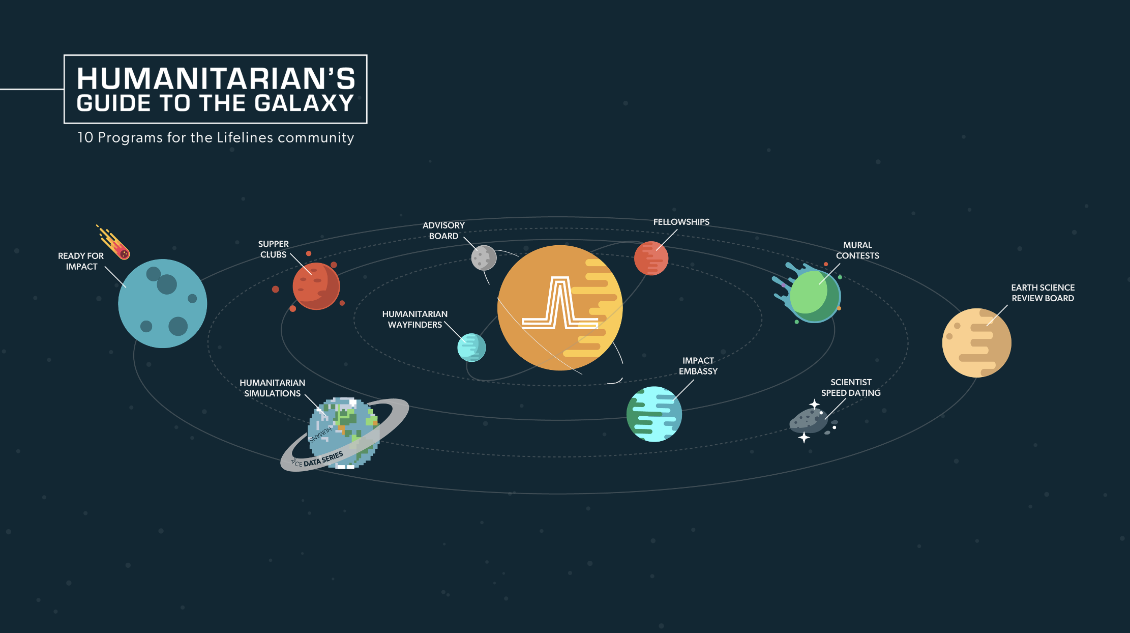
NASA Lifelines comprises a variety of unique programs and outreach efforts, each addressing a particular challenge to innovation and collaboration around humanitarian use of satellite imagery.
Two NASA Lifelines Humanitarian Wayfinder organizations, who are already using Earth science to shape their humanitarian efforts, are leading the way for other humanitarian organizations. These organizations – PAX for Peace and ICDDR,B, each pursue unique missions – building inclusive peace, and addressing public health problems, respectively. Each organization has already demonstrated the effectiveness of leveraging Earth science.
Shaping the programming are Advisors, experts bringing their depth of experience to guide the strategy of the initiative, and Fellows who bring new perspectives as they amplify program operations.
Building a Community of Action
Scientists, researchers, and other Earth observation experts are hungry for spaces where cutting-edge solutions and hypotheses can be tested, cross-pollinated with other ideas, and checked against real-world situations. NASA Lifelines’ first Scientist Speed Dating event recently brought over 30 of these eager experts together. They connected not only with others in their field but were also matched with humanitarian practitioners who shared their needs, challenges and hopes for using satellite data in their work. Many NASA participants joined the conversation, bringing their unique perspectives and valuable Earth science experience.
![Jeff Pituch stands at the front of a room giving a presentation at the Scientist Speed Dating event. Groups of people sit at tables, eager to participate in this networking event.]](https://appliedsciences.nasa.gov/sites/default/files/IMG_5732.JPG)
Taking another angle, a NASA Lifelines Supper Club recently brought together two small groups composed of humanitarians, NASA scientists, and private sector technologists to explore targeted questions like “How can we create better partnerships between satellite imagery, Earth science companies, and on-the-ground organizations and communities?” Participants shared their frank perspectives, empowered by the Chatham House Rule, which ensured their identities and affiliations remained anonymous to foster open dialogue. Multiple collaborations have already emerged from each Supper Club – from connecting teams to new resources, to exploring potential in-depth partnerships.

Continuing to Weave the NASA Lifelines Community
Fundamentally, NASA Lifelines is a community-building effort dedicated to having real impacts that enable more effective and impactful humanitarian use of satellite technologies. By approaching challenges from different angles, the initiative hopes to fast-track information exchange, collaboration, and growth.
NASA Lifelines has many other projects and initiatives planned for the coming year. In October 2024, the initiative will invite community members to join their Humanitarian Simulation. In this collaborative, global, online crisis simulation, participants will explore using satellite data to answer key humanitarian challenges. Simulation participants will join teams to face a fictional humanitarian crisis and will work with satellite imagery to support the response. The event is open to all interested parties working around these topics – or keen to. It’s another thread NASA Lifelines is weaving to strengthen the community and advance humanitarian action.
To learn more and join the Humanitarian Simulation, visit https://nasalifelines.org/humanitarian-simulations/
This is only the beginning of NASA Lifelines. The foundation is being laid, and the years ahead hold great potential. Follow along with the journey on the NASA Lifelines website, LinkedIn and Instagram to explore the entire galaxy of programming and dive in!


