Start Date: Oct. 8, 2024
Type: Hurricanes & Cyclones
Region: North America
View maps and data on the NASA Disasters Mapping Portal
What DHS and FEMA are doing: https://www.fema.gov/hurricane-milton (Spanish: https://www.fema.gov/es/milton )
What the U.S. government is doing: https://usa.gov/hurricane-milton (Spanish: https://usa.gov/es/huracan-milton)
UPDATE OCT. 18, 2024
As Florida communities recover from the impacts of Hurricane Milton, the Disasters Response Coordination System remains activated to assist FEMA and other response agencies. The DRCS is continuing to produce maps and data as they become available and is sharing them on the NASA Disasters Mapping Portal.
Last weekend the DRCS coordinated with NASA’s Airborne Science Program and FEMA to conduct a series of flights with NASA’s Uninhabited Aerial Synthetic Aperture Radar (UAVSAR) instrument. The flights collected data on coastal and inland water extent, providing critical awareness of flooding and flood damage in areas that have been challenging to obtain satellite observations due to cloud-cover. These data contributed to FEMA and state partner’s operational awareness of conditions in the region, aiding their response efforts and resource deployment. OPERA Dynamic Surface Water eXtent (DSWx) maps, Copernicus Sentinel 1 flood extent maps, and NASA/USGS Landsat 8 & 9 optical imagery have also contributed to partners’ awareness of water extent and flooding in the region.
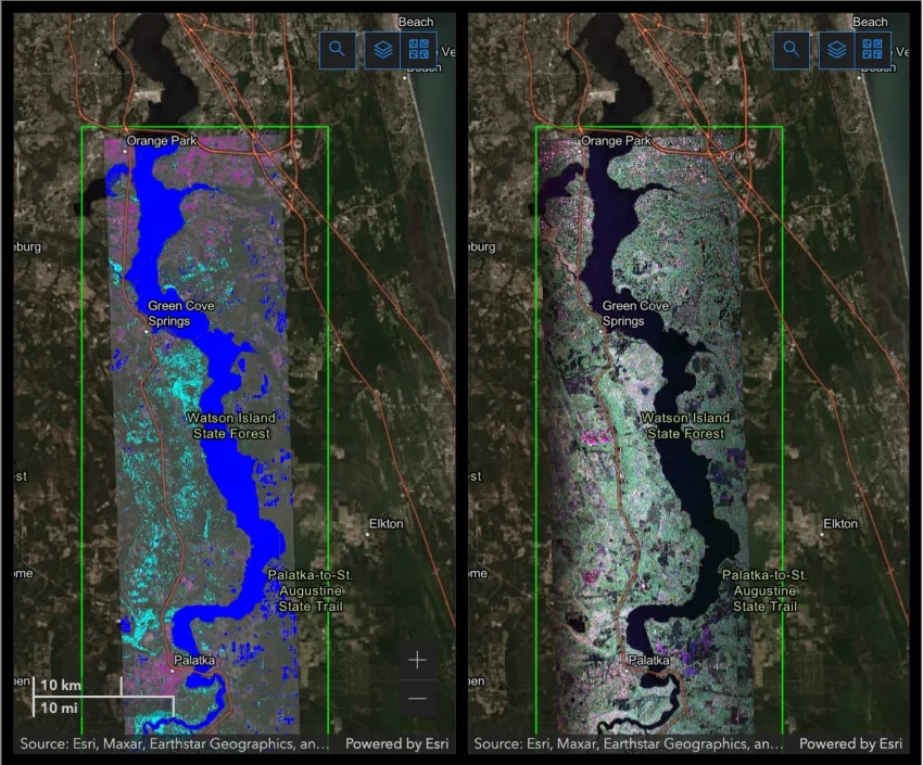
This map shows UAVSAR data from the area surrounding St. Johns River, Florida, which saw flooding from Hurricane Milton. The map compares false-color raster data (right) with derived water extents (left), which can aid in detecting flooded areas. In the water extent map on the left, blue indicates open water, cyan indicates potentially flooded vegetation, and pink indicates potentially flooded urban areas. On the right RGB raster map, green indicates vegetated areas, pink indicates inundated forest and fields as well as urban areas, and black and dark gray indicate open water and smooth surfaces such as roads and bare ground. Credits: NASA JPL, DRCS
Response partners have been using NASA’s Black Marble product for information on nighttime lights conditions throughout the preparation and response for Hurricane Helene. By comparing conditions before and after the event, partners can gain an understanding of areas that may have lost power, and areas where power may have been restored in the days following landfall.
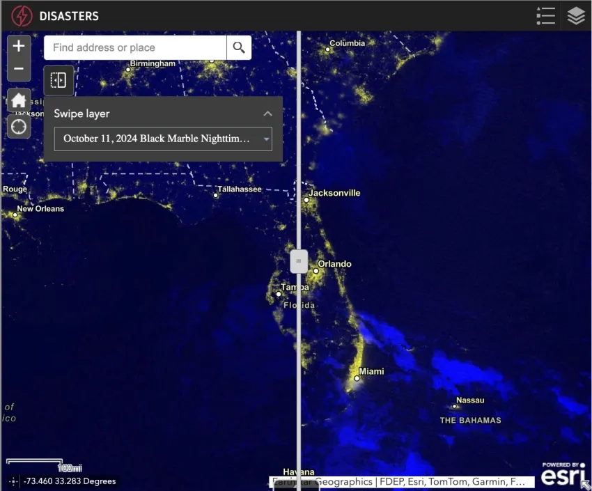
This map shows nighttime lights conditions in Florida from before (left, Sept. 24 and Oct. 4. 2024) and after (right, Oct. 17, 2024) Hurricanes Helene and Milton made landfall. The data is from NASA’s Black Marble Nighttime Lights Blue/Yellow Composite product using NOAA-20 VIIRS & and NASA/NOAA Suomi NPP VIIRS data. Credits: NASA/GSFC/ESDIS, NASA GIBS
UPDATE OCT. 10, 2024
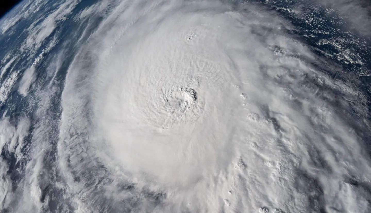
Hurricane Milton made landfall with central Florida the evening of Wed. Oct. 9, bringing destructive tornadoes, wind damage, flooding and storm surge. As Florida communities face these impacts, the Disasters Response Coordination System is working closely with FEMA and state emergency management agencies to support their response efforts.
The DRCS continues to attend interagency coordination calls to assess needs from response partners, and to share Earth observation maps and data on the NASA Disasters Mapping Portal.
The DRCS is also working with NASA’s Airborne Science Program to conduct a series of flights Friday and throughout the weekend to provide awareness of flooding in Florida in the wake of Hurricane Milton.
NASA’s Uninhabited Aerial Synthetic Aperture Radar Vehicle (UAVSAR) instrument will collect rapid, wide-area L-Band synthetic aperture radar data across the region. The data and derived water extents which will be shared directly with the Federal Emergency Management Agency (FEMA) and state emergency management agencies to support their response efforts. The DRCS are directing the flights in coordination with FEMA to enhance their existing satellite and aerial data collection.
Since Hurricane Milton struck, persistent cloud cover over Florida has made it difficult to obtain optical satellite observations of the region’s conditions. Synthetic aperture radar instruments, like those on UAVSAR, can penetrate the clouds to observe changes on the ground. This provides essential observations of flood inundation across Florida communities and the extent of inland river flooding, aiding response teams in assessing damage and allocating resources.
UPDATE OCT. 9, 2024
As Hurricane Milton approaches central Florida, the Disasters Response Coordination System (DRCS) continues to work closely with FEMA and other response agencies, providing NASA science and data to inform their efforts.

The DRCS team is processing and sharing pre-event satellite imagery and near real-time data, which provide information on current conditions in Florida and can be compared to post-event imagery to help identify damaged and flooded areas. The team are sharing maps and data directly with response partners as well as on the NASA Disasters Mapping Portal. These products include NASA Black Marble Blue/Yellow Composite nIghttime lights data, NASA Land Information System (LIS) soil moisture data, MODIS daily flood detection products, and half-hourly NASA IMERG satellite precipitation estimates.
These maps and data leverage NASA’s unique capabilities to monitor Earth from space, equipping decision-makers with essential tools to prepare for and respond to Miltons impacts.

UPDATE OCT. 8, 2024
The Disasters Response Coordination System (DRCS) has activated to support FEMA and state agencies in responding to Hurricane Milton. Milton is currently a Category 4 storm tracking toward central Florida and is anticipated to make landfall Wednesday night. Forecasts indicate the storm will bring destructive winds, flooding, and storm surge to communities in Florida, impacting a region that is still recovering from the damage caused by Hurricane Helene just two weeks ago. The DRCS is also continuing its efforts supporting response and recovery in the southern U.S. for Helene.
DRCS team members are participating in coordination calls with agency partners to assess needs and are sharing pre-event maps and imagery on the NASA Disasters Mapping Portal to aid situational awareness and equip decision-makers with the best available information to prepare for Milton’s impacts.
This pre-event coordination is essential, as the compounding effects of two sequential disasters can complicate response and recovery efforts for both emergency managers and local communities. Debris from Helene and damage to coastal barriers could increase communities' vulnerability to storm surge and high winds. Additionally, soil moisture levels in many areas of Florida are still high from the heavy rainfall brought by Helene, which makes flooding more likely as the ground is not able to absorb as much water.

About the Disasters Response Coordination System
As a core element of the Disasters Program within NASA’s Earth Science Division, the Disasters Response Coordination System (DRCS) provides trusted, timely, and actionable science to aid organizations actively responding to disasters. NASA centers supporting the DRCS response include Ames Research Center (ARC), Goddard Space Flight Center (GSFC), Jet Propulsion Laboratory (JPL) and the California Institute of Technology, Johnson Space Center (JSC), Marshall Space Flight Center (MSFC), and Langley Research Center (LaRC).
More On Hurricane Milton
- NASA Activates Resources to Help Assess Impacts from Hurricane Milton
- NASA Earth Observatory
- NASA/JAXA Global Precipitation Measurement Mission