Start Date: Feb. 6, 2023
Type: Earthquakes, Landslides
Region: Europe / Asia
NASA Resources:
- View maps and data on the NASA Disasters Mapping Portal
- NASA Earth Observatory Updates:
- NASA ARIA Share – Türkiye
- NASA Earthdata Pathfinders - Earthquakes and Volcanoes
- NASA Earthdata Toolkits - Earthquakes and Volcanoes
External Resources:
- USAID - The United States’ Response to Türkiye / Syria Earthquakes
- USGS Event Pages – M7.8 Earthquake, M7.5 Earthquake
- Esri Disaster Response Program Event Page
- GEO Marmara Region Geohazards Supersite
UPDATE MARCH 7, 2023:
On Feb. 20, Türkiye was struck by another powerful 6.3 magnitude earthquake near the Syrian border, just weeks after the initial 7.8 magnitude event. The latest earthquake resulted in significantly less casualties than prior events because it occurred in Türkiye’s Hatay province, where many of the inhabitants had already evacuated following the initial Feb. 6 earthquakes. Coordinators from NASA’s Earth Applied Sciences Disasters program area continue to monitor the region and are providing Earth observing data to multiple stakeholders to aid their disaster response and recovery efforts.

The Advanced Rapid Imaging and Analysis (ARIA) team, a collaboration between NASA’s Jet Propulsion Laboratory and the California Institute of Technology, generated displacement maps to show how the Earth’s surface moved following the Feb. 20 earthquake. The team used Copernicus Sentinel-1 synthetic aperture radar (SAR) data acquired before (Feb. 9) and after (Feb. 21) the event to generate the imagery. The map shows that the 6.3 magnitude earthquake ruptured a fault roughly 15 miles (25 km) long between the city of Antakya and the coastal cities in the Hatay province of Türkiye. These products are freely available on the NASA ARIA Share website, and the NASA Disasters team shared these with the USGS and other stakeholders to help understand the geological conditions surrounding the earthquakes.

NASA’s landslides team, based at Goddard Space Flight Center (GSFC), has been investigating the region for landslide activity following the earthquakes, and manually identified over 100 landslides in cloud and snow-free regions using high resolution PlanetScope data. The team overlaid the landslide points with road data and provided maps to the World Central Kitchen (WCK) to aid their humanitarian efforts delivering food and water to the earthquake victims.
“The team looked at imagery from before and after the event to determine that the landslides were triggered by the recent earthquakes. However, there is no way to guarantee that the landslides were in fact triggered by the earthquakes themselves rather than the snow and rain that followed soon after,” said Rachel Soobitsky, a NASA GSFC Disasters Coordinator supporting the event. “The landslide triggers are less important for response purposes, but they becomes more important when we use the data later to validate our landslide hazard models.”
Learn more at NASA Earth Observatory: Landslides in Türkiye
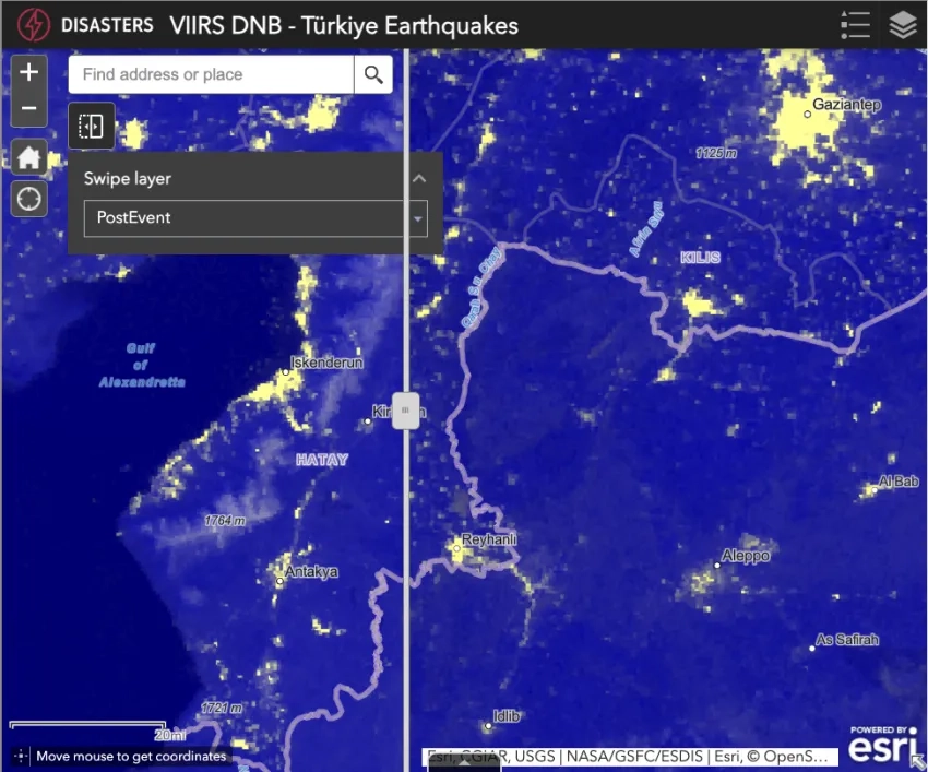
Black Marble Blue/Yellow Composite nighttime lights imagery from before (Jan. 3. 2023) and after (Feb. 8, 2023) the initial earthquakes. Credits: NASA Disasters Mapping Portal
The NASA Disasters team shared Black Marble Blue/Yellow Composite data on the Disasters Mapping Portal. NASA’s Land, Atmosphere Near-real-time Capability for EOS (LANCE) produces the at-sensor radiance and long wave infrared imagery from Suomi NPP VIIRS that go into making the colorized blue-yellow composite, which allows for easier differentiation between land, clouds, and nighttime lights. LANCE makes these data available for near real-time download which enables quick assessment of the conditions during a disaster. Other products such as Black Marble HD can show increased detail while taking longer to be made available, making them more suitable for post-event assessments. These imagery can help guide relief teams by identifying regions which may be without power and in need of aid.
Learn more at NASA Earth Observatory: Dark Nights in Antakya
The United States Department of Agriculture's Foreign Agricultural Service (USDA-FAS) worked with NASA Disasters to explore remote sensing products to increase situational awareness of the disaster and assess damage to crops and infrastructure, building on established connections with the NASA Disasters project “Integrating SAR Data for Improved Resilience and Response to Weather-Related Disasters”. The Disasters team offered some hands-on examples of how to best use damage proxy maps in combination with other high-resolution data, and shared the landslide location maps and other high-resolution processed satellite imagery. The USDA-FAS also shared multiple resources with NASA and provided valuable feedback on how response teams can use satellite imagery to track flooding and infrastructure damage. The meetings served as a valuable information exchange which strengthened collaboration between the two organizations and expanded their disaster response capabilities.
The NASA Disasters program is closely following the aftermath in Türkiye and Syria and is ready to provide aid for additional response and recovery efforts. As new information becomes available, the team will post maps and data products on the Disasters Mapping Portal.
UPDATE FEB. 10, 2023:
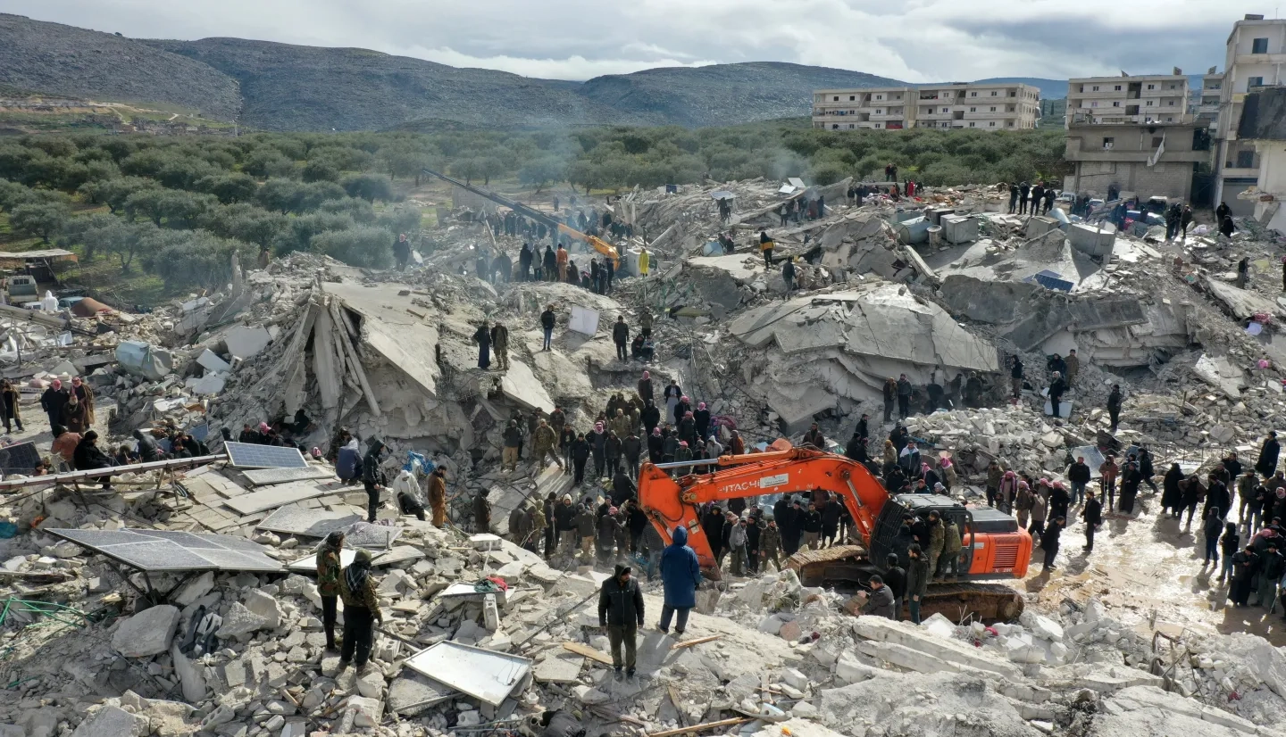
On Feb. 6, 2023, Türkiye and Syria were hit by the most powerful earthquakes to strike the region in almost 100 years. As of Feb. 10, the death toll between both countries has risen to over 22,000 following the 7.8 magnitude quake and hundreds of subsequent aftershocks. The initial quake struck only 150 miles away from the Türkiye-Syria border and was followed by a powerful 7.5 magnitude earthquake just nine hours later. In Syria, the civil war has separated the country between rebel controlled-areas and government controlled-areas, making it difficult for victims to receive life-saving aid. Additionally, many Syrian victims were already suffering from extreme poverty and cholera at the time of the earthquake, making humanitarian relief efforts exceptionally challenging. Currently, response teams are racing against potential snowstorms to rescue survivors from the rubble before freezing conditions set in.

NASA’s Earth Applied Sciences Disasters program area is coordinating with stakeholders including the U.S. Department of State, U.S. Agency for International Development (USAID), the California Seismic Safety Commission, the U.S. Geological Survey (USGS) National Earthquake Hazards Reduction Program (NEHRP), Team Rubicon and the World Central Kitchen (WCK), providing maps, data and scientific expertise to aid ongoing response efforts and risk assessments. Major concerns include damage to electrical grids, blocked roads, and damaged airports. The NASA Disasters team is participating in regular coordination calls hosted by USAID, who have deployed a Disaster Assistance Response Team (DART) to lead the U.S. government’s response efforts in support of the Government of Türkiye. The NASA Disasters team is publishing maps and data in support of the event on the open access Disasters Mapping Portal.

Cloud cover initially made it difficult for optical satellite sensors to observe the region for damage assessment, but on Feb. 8 an overpass by JAXA’s Advanced Land Observing Satellite-2 (ALOS-2) satellite collected synthetic aperture radar (SAR) observations which can see through the clouds. This enabled the generation of damage proxy maps (DPM’s) showing estimated damage to buildings and infrastructure. The Earth Observatory of Singapore - Remote Sensing Lab created a DPM that depicts changes in the landscape and characterizes the potential location, extent, and severity of the damage following the event, in collaboration with NASA’s Jet Propulsion Laboratory. NASA’s Disasters team shared this DPM and supporting data with the Miyamoto Global Disaster Relief non-profit, who are collaborating with the World Bank and Turkish government, and with the California Seismic Safety Commission, who are using the data to aid search and rescue teams on the ground in Türkiye.
Learn more at NASA Earth Observatory: Earthquake Damage in Türkiye

The SAR data also enabled the generation of surface displacement maps, which show the movement of the Earth’s surface due to the earthquakes. NASA shared this data with USGS seismologists who are using the data to analyze the geological conditions leading to the earthquakes and assess the risk of further aftershocks in the regions.
The interferograms provide information on the rupture length and variations in the amount of slip along the faults, which helps to estimate the slip at depth and the change in stress on nearby faults, providing information on the areas where aftershocks are more likely. These displacement maps also helped to confirm assumptions from initial seismic readings that the earthquakes originated from ruptures in both the East Anatolian Fault and the Dead Sea Fault systems. The rupture of these two faults may have greatly increased the area impacted by these earthquakes.
NASA’s landslides team based at Goddard Space Flight Center is monitoring the region for landslide activity, but recent snowfall and cloud cover have made it difficult for Earth-observing satellites and models to detect landslides. Despite this the team was able to manually identify 58 landslides in cloud and snow-free regions using high resolution PlanetScope data. The team then overlaid this with road data and provided maps to the WCK to aid their humanitarian efforts delivering food and water to the earthquake victims. Landslide risk assessment is particularly important as December, January, and February are the rainiest months of the year for this region, leading to an increase in rainfall-triggered landslides.
Additional products made available by the NASA Disasters team include photography of the region by astronauts onboard the International Space Station, natural color and true-color imagery from the Copernicus Sentinel-2 satellite, and “Black Marble” nighttime lights imagery derived from Suomi-NPP VIIRS data which can be used to identify loss of light in the region which may indicate potential power outages. NASA is also sharing data and coordinating with the Esri Disaster Response Program, who are making data freely available on ArcGIS Online.
As the disaster in Türkiye and Syria continues to unfold, NASA’s Disaster team stands ready to support partners with Earth-observing data and expertise to aid international response and recovery efforts.

Story by Jacob Reed and Gabriella Lewis, NASA Disasters