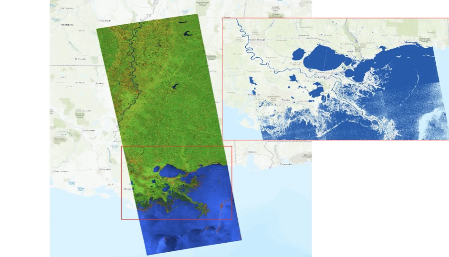
Weather-related hazards, such as flash flooding and hurricane surges, are natural phenomena that can have devastating impacts on communities worldwide. As a result, disaster responders must react as quickly as possible to mitigate the impact on people and their homes. Synthetic Aperture Radar (SAR) – satellites that provide images of land on Earth – help monitor weather-related hazards with an ability to see an area day and night, rain or shine. However, SAR is complicated to use and time-consuming, thus creating the need for products that can speed up the imaging process.
Franz Meyer’s A.37 ROSES project is developing a data analysis toolbox that will automatically process SAR data into comprehensible products for end-users in disaster response. Meyer is collaborating with the U.S. Department of Agriculture Foreign Agricultural Service (USDA-FAS), the National Weather Service Alaska-Pacific River Forecast Center (APRFC), the Federal Emergency Management Agency and private industry representative Corteva to ensure successful adoption of the new technology. Despite the COVID-19 pandemic, the project has continued to advance, applying SAR data to multiple hazards in 2020, such as the 2020 flooding events in Colombia and Honduras, the monsoon flood period in South Asia, and many more.
Full Description
Weather-related hazards are ubiquitous in the United States, including: 1) hurricane storm surges impacting coastal areas, 2) rapid snowmelt and heavy rainfall causing basin-scale flooding, 3) severe weather leading to flash floods and tornadoes, and 4) seasonal freeze and thaw of rivers that may lead to ice jams. Each of these hazards affects human settlements ranging from major cities to rural areas and has the potential to significantly impact agricultural productivity. In each setting, end-user partners engaged in disaster management need access to data-processing tools helpful in mapping past and current disasters to capture their impacts. Analysis of past events supports risk mitigation by understanding what has already occurred and how to alleviate those impacts in the future.
Similarly, having capabilities to generate the same products in a response setting means that lessons learned from risk analysis will carry forward to event response. Synthetic aperture radar (SAR) data are particularly useful for these activities due to their all-weather, 24/7 monitoring capabilities. However, complex processing and high computational costs associated with SAR require the development of approaches that streamline product generation.
To meet this need, this project will develop a cloud-based automatic data analysis toolbox for the processing of SAR data into value-added products that address the mapping of meteorological and hydrological disasters, such as heavy rainfall and flooding, as well as related cascading hazards, such as landslides and levee instability. The integration of these products into end-user decision-making workflows will improve capacity in the use of SAR in response situations.
Furthermore, the SAR analysis tools will assist in preparing for and mitigating risk by allowing users to process image time series gathered from NASA Distributed Active Archive Centers or through their purchasing of commercial data. To ensure adoption of the developed technology by end-users, we will partner with several organizations interested in managing and monitoring meteorological and hydrological disasters. Cost-sharing partners include the United States Department of Agriculture Foreign Agricultural Service and the National Weather Service Alaska-Pacific River Forecast Center. Beyond these cost-sharing partners, we will also work with the Federal Emergency Management Agency and private industry representative DuPont, who will both participate in the project but are legally prevented from providing cost share or letters of support.