
NASA has a wealth of satellite data that can help improve food security and agricultural monitoring across the planet. Mary Mitkish wants that information to be accessible to the people who need it most. She is the assistant program manager and communications lead for NASA's Harvest consortium. A project of the Applied Sciences' Agriculture program area, NASA Harvest brings together partners from a diversity of sectors and is led by researchers at the University of Maryland. In her role, Mitkish says she has a rare opportunity to work with innovative technology in service of the greater public good. She will take part in a panel discussion called “Tackling Food Insecurity with NASA Satellite Data” at South by Southwest (SXSW) in Austin on March 11, 2023. Ahead of that appearance, we asked her six questions about her work.
You graduated from the University of Pittsburgh with a degree in Communication Science and Disorders. Can you tell us about your path from there to you current rols as assistant program manager and communications lead for the NASA Harvest consortium?
The short version of the story is that I got really lucky! I knew after my first year as an audiology student at the University of Maryland that it wasn’t the right career path for me. In the meantime, though, I had taken a position in the Department of Geographical Sciences to help pay the bills. It was there that I began working with Christopher Justice, then department chair and now NASA Harvest’s chief scientist. That's when I began my journey into the world of satellite data applications for agriculture and food security. When NASA Harvest was in search of administrative and communications support, I jumped at the opportunity. I have been learning and growing with the consortium ever since.
What excites you most about your role?
That’s an easy one: the NASA Harvest mission and the incredible people I get to work with excite me most about my role. Every day I learn about a new way that our team has aided in humanitarian efforts or used satellite imagery to support better-informed agricultural decision making.
For example, our GEOGLAM-NASA Harvest Agrometeorological (AGMET) Earth Observation Indicators tool and our Global Agricultural Monitoring (GLAM) interactive dashboard are both available online. With the click of a few buttons and a bit of background knowledge, anybody in the world can gain valuable insights on crop conditions. This information can enable early action to prevent a food crisis. Similarly, our Harvest2Market dashboard is a one-stop-shop for agricultural conditions and market information. It was built in response to the Russian invasion of Ukraine at a time when markets were especially volatile and ground access was—and still is—dangerous and limited.
Has your work with NASA Harvest changed the way you think about food or the environment?
Absolutely. Many of us think about NASA as our space exploration agency, which is true of course, but NASA does so much more than that! In fact, a huge part of NASA’s directive is to explore our home planet—and in NASA Harvest’s case, to explore Earth’s agricultural and food systems.
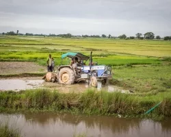
Before my time with Harvest, I never really considered where my food came from or the impacts of agriculture on the environment. We talk about the effects of climate change all the time, but how does this relate to our food and its cost? Severe weather events are increasing as a result of climate change. We’re seeing more prevalent droughts, less resilient soil and frequent storms. These and other weather-related events affect food production and distribution. We need to make sure that we provide the best information on environmental conditions that impact agriculture. Good information means better farming decisions, and early information helps bolster market stability.
What’s been one of the most fascinating or surprising collaborations you’ve seen in the NASA Harvest consortium?
One of our most fascinating collaborations at the moment is our work with the Ministry of Agrarian Policy and Food of Ukraine and Planet, a key private sector consortium partner. Since the beginning of the Russian invasion of Ukraine, there was immediate concern about agricultural production. The Black Sea region is among the world’s top five grain exporting regions. Disruption in this area meant widespread food security consequences and food price spikes.
NASA Harvest’s timely assessments of planted areas and harvested areas were valuable to understand how much food would be available—both for Ukrainian consumption and for international markets. Without satellite information, we would essentially be in the dark about the status of agricultural production in the war-stricken region. Plus, this work is an incredible collaborative effort. We see private, public, and non-governmental organizations partners eagerly working together to serve a common good—something I find to be quite unique to Harvest’s consortium framework.
What do you see as the greatest barriers to getting stakeholders access to useful remote-sensing data?
Raw satellite data is rarely digestible for end users. Farmers, policy makers, economists, and other stakeholders might not be remote sensing experts. But they could benefit from the insights that satellite data provides. We really need to present the satellite data in such a way that users can easily understand. This is why NASA Harvest works with a variety of stakeholders across the agriculture spectrum. We integrate satellite data into existing tools and create new Earth observation-based products that best serve a diverse set of stakeholder needs. We also conduct training sessions as often as necessary.
What's your vision for the future of NASA Harvest?
My vision for NASA Harvest in the next five years is to further develop strong partnerships and scale our Earth observation-based tools. The ultimate goal is to ensure that anyone who is looking for better information can access it. Realistically, this doesn’t happen overnight or in a silo. Our partners work in the public, private, humanitarian, and academic sectors. And I believe that we can achieve so much more working together. We want users to be able to take confident action—no matter if they are planting, timing their fertilizer application, or establishing humanitarian aid requirements.