The project developed a robust end-to-end automatic system to rapidly generate and deliver flood extent maps to responding agencies in 10 GEO member countries and to support the flood modeling community. This project support 35 disasters events with Flood Proxy Maps - users include: United States Federal Emergency Management Agency; Search and Rescue Assistance in Disasters; United Nations Development Programme, International Children’s Emergency Fund and the Office for the Coordination of Humanitarian Affairs; United States Forest Service; United States Air Force; World Bank; World Food Programme; United States Southern Command; Sentinel Asia; ASEAN Humanitarian Assistance Centre; Asian Disaster Reduction Center; Badan Nasional Penanggulangan Bencana, and Changi Regional HADR Coordination Centre.
Key Highlights Include
- Four algorithms were developed: Flood Proxy Map (FPM) 1 before and after inclusion of Synthetic Aperture Radar (SAR) data; FPM2 with includes multi-temporal SAR analysis; FPM 3 which includes machine learning-based (CNN) semantic segmentation and FPM4 which includes machine learning-based (RNN) anomaly score map.
- FPM1 was incorporated into the ARIA system. ARIA is a collaboration between JPL and Caltech to exploit radar and optical remote sensing, GPS, and seismic observations for hazard science and response.
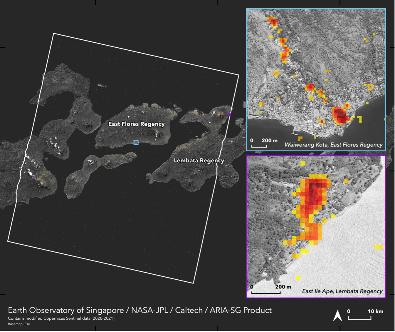
- Strong collaboration with the Earth Observatory of Singapore on improving mapping algorithms and system maturity.
Selected Peer Review Publications
Ho, H., Park, E., Chitwatkulsiri, D., Lim, J., Yun, S., Maneechot, L., Phuong, D., “Local rainfall or river overflow? Re-evaluating the cause of the Great 2011 Thailand flood”, Journal of Hydrology, 589, DOI: 10.1016/j.jhydrol.2020.125368, October, 2020.
Ulloa, N., Chiang, S., Yun, S., “Flood Proxy Mapping with Normalized Backscattering Index and Entropy”, Remote Sensing, DOI:10.3390/rs12091384, April, 2020.
Tay, C., Yun, S., Chin, S., Bhardwaj, A., Jung, J., Hill, E.M., “Rapid Flood and Damage Mapping Using Synthetic Aperture Radar in Response to Typhoon Hagibis, Japan”, Scientific Data, DOI: https://doi.org/10.1038/s41597-020-0443-5, March, 2020.
Selected Media Releases
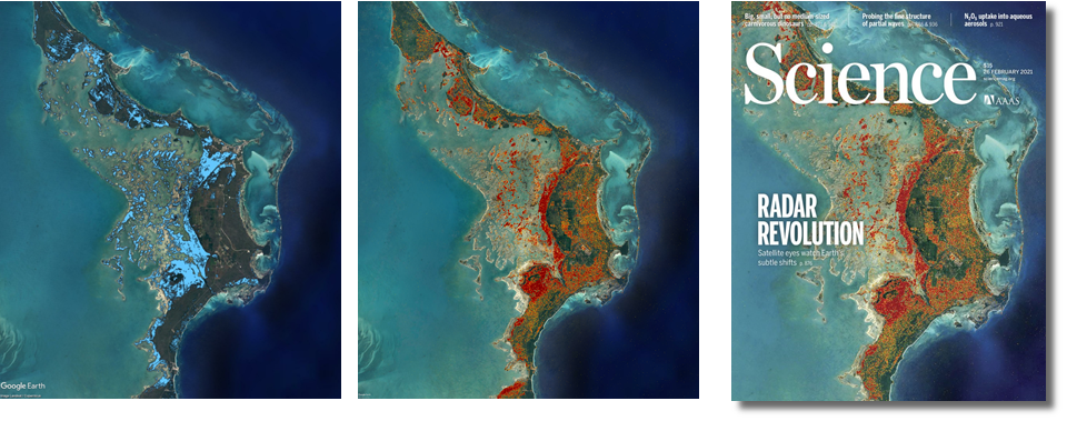
Science Magazine “Radar Revolution”
Featured as a cover image of the 2021 February 26th issue of Science. Available online at: https://science.sciencemag.org/content/371/6532?current-issue=y
“VISUALS”, Science, March 19, 2021. Available online at: https://blogs.sciencemag.org/vis/2021/03/19/measuring-global-change/
Figures provided for the feature article, “Fleets of radar satellites are measuring movements on Earth like never before”, Science, February 25, 2021. Available online at: https://www.sciencemag.org/news/2021/02/fleets-radar-satellites-are-measuring-movements-earth-never
Laos Floods
“Laos Flooding June 2021”, NASA Applied Sciences Website, June 13, 2021. Available online at: https://appliedsciences.nasa.gov/what-we-do/disasters/disasters-activations/laos-flooding-june-2021
NPR Innovation Now
“In the Wake of Disaster”, NPR Innovation Now, April 23, 2021. Available online at: https://www.npr.org/podcasts/559075110/innovation-now
March 2021 New South Wales Floods in Australia
“Historic Floods in New South Wales”, NASA Earth Observatory, March 24, 2021. Available online at: https://earthobservatory.nasa.gov/images/148093/historic-floods-in-new-south-wales
“Australia Floods 2021”, NASA Earth Science Applied Sciences, March 20, 2021. Available online at: https://appliedsciences.nasa.gov/what-we-do/disasters/disasters-activations/australia-floods-2021