Displaying 11 - 11 of 11
![The data come from Landsat 9 OLI and MODIS satellites. The data shows surface reflectance imagery and combined (Terra and Aqua) MODIS burned areas from wildland fires in February 2023. The image shows parts of South-Central Chile covering Región del Maule, Región del Bío-Bío, and Región de La Araucanía. The processed data show burned areas in the region of interest from wildland fires and the smog from the fires. Red patches indicate burned areas.](/sites/default/files/styles/lis/public/2024-01/2023Sum_PUP_ChileWildlandFires_WebsiteImage.jpg.webp?itok=M4LTKzkk)
Topic
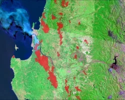
Chile Wildland Fires (Summer 2023) Team: Benjamin D. Goffin (Project Lead), Quinton Deppert, Aashutosh Aryal Summary: Since 2010, Central and South-Central Chile have recorded abnormally...