Gold mining is a central component of Ghana’s economy. An increased amount of illegal artisanal mining in recent years has led to accelerated deforestation, destruction of protected areas, and human health issues due to Mercury used during the mining process. This project addresses Sustainable Development Goal (SDG) 15 (Life on Land) by utilizing in-situ and Earth Observation data to analyze forest health patterns due to artisanal gold mining and urbanization in southwestern Ghana.
Outputs & Impact
Creation of a web-based land use analysis manuscript for use by the government of Ghana (SDG 15.1.1 & 15.2.1)
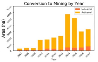
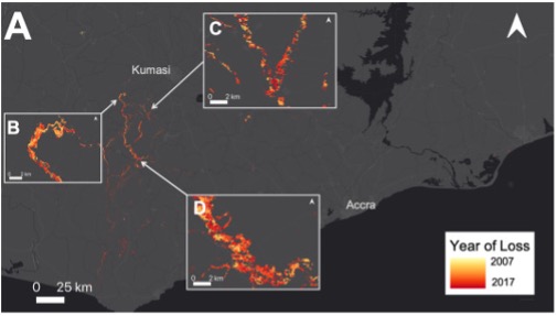
The team developed and published a method to use satellite earth observation data to estimate the transition of vegetation to mining in both large and small scale mines. The tool uses observation from Landsat between 2002 and 2005 to estimate changes in Normalized Differential Vegetation Index, then uses a Machine Learning algorithm to classify areas that have changed from vegetation to water, mines or urban areas: This work has been published in a peer reviewed journal article called "The Large Footprint of Small-scale Artisanal Mining in Ghana," which is publishes as a collaboration between the US and Ghanian collaborators. Additional work is exploring how satellites reveal river water quality impacted due to mining, building on local water sampling efforts. The work is shared via a free online tool visualizing the study results.
Creation of climate vulnerability analysis models for use by the government of Ghana (SDG 15.1.1 & 15.2.1)
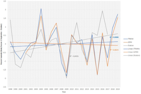
The team performed climate analysis to explore how temperature and rainfall are changing. This is accompanied by a national analysis comparing how land use and land cover change between 2015 and 2020. Together these analyses inform how humans are influencing the growth and health of forest in Ghana. The land cover change analysis also uses Landsat imagery and is shared online via Google Earth Engine.