The Mapping the Missing Millions project undertook a diverse collection of Earth observation (EO)-based assessments at refugee camps that collectively provide path-breaking insights into settlement dynamics, land cover change, and climate change effects at the world’s refugee camps. The project first examined EO-opportunities for refugee settlement detection. The project team developed a machine learning approach for refugee settlement detection using very high resolution Maxar imagery over all of Uganda, and identified refugee settlements with 95% accuracy. As a complement to the machine learning approach, the project crowdsourced the detection of refugee settlements across 76,000 km2 in Uganda using Sentinel-2 imagery and the contributions of 562 people around the world, with the MapSwipe application. Finally, an analysis of the detection of refugee settlements of four leading EO-based human settlement products showed that refugee sites are commonly overlooked, highlighting the need for refugee settlements to be included in the calibration and validation of human settlement dataset production.
This project also sought to capture long-term changes in refugee settlement land cover dynamics at national- and continental-scales through systematic analysis, going beyond the typical rapid response assessment of environmental impacts or dwelling enumeration. Landsat and Sentinel-2 time series data and automated landscape disturbance detection approaches helped capture the rapid establishment and growth of refugee settlements in Uganda and detail land use changes within and surrounding refugee settlements corresponding to small-scale farming in and surrounding refugee settlements. At the continental-scale, the project used MODIS data to quantify the prevalence of agricultural deforestation around 493 refugee camps across 49 countries in Africa, showing that encamped refugees have not disproportionately degraded the surrounding landscape as has often been claimed.
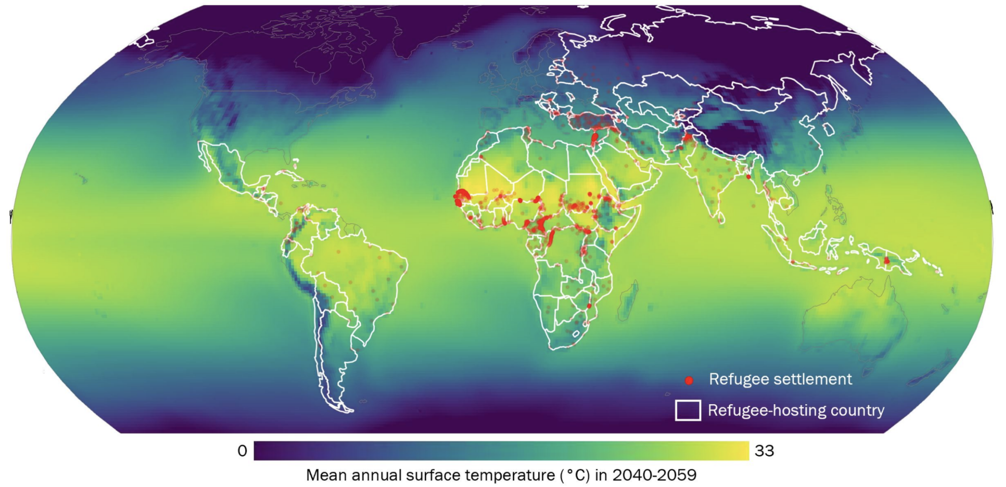
The project also provided the first systematic examination of modeled future climate conditions at global refugee camps across varied emission scenarios and time horizons using CMIP6 data, finding that current refugee settlements are likely to see disproportionately high temperatures and erratic precipitation regimes. This perspective is highlighted in the forthcoming IPCC AR6 report for which the project PI is a contributing author. With the new awareness of broad-scale climate conditions at refugee camps, the project developed a social justice framework to guide the relocation of refugee settlements exposed to extreme climate change. The project also developed an agenda for sustainable refugee-environment relationships in a changing climate.
EO data used: Landsat, Sentinel-2, MODIS, PlanetScope, WorldView-4, and various EO-derived datasets: Global Human Settlement Layer (GHSL), Geo-Referenced Infrastructure and Demographic Data for Development (GRID3), High Resolution Settlement Layer (HRSL), World Settlement Footprint (WSF)
Project partners: Humanitarian OpenStreetMap Team and DevSeed
Links:
- Missing Millions project page
- Friedrich, H. K., & Van Den Hoek, J. (2020). Breaking ground: Automated disturbance detection with Landsat time series captures rapid refugee settlement establishment and growth in North Uganda. Computers, Environment and Urban Systems, 82, 101499.
- Maystadt, J. F., Mueller, V., Van Den Hoek, J., & Van Weezel, S. (2020). Vegetation changes attributable to refugees in Africa coincide with agricultural deforestation. Environmental Research Letters, 15(4), 044008.
- Peters, L. E., & Van Den Hoek, J. (2021). Charting a justice-based approach to planned climate relocation for the world's refugees. Global Views on Climate Relocation and Social Justice: Navigating Retreat.
- Van Den Hoek, J., & Friedrich, H. K. (2021). Satellite-Based Human Settlement Datasets Inadequately Detect Refugee Settlements: A Critical Assessment at Thirty Refugee Settlements in Uganda. Remote Sensing, 13(18), 3574.
- Van Den Hoek, J., Friedrich, H. K., Ballasiotes, A., Peters, L. E., & Wrathall, D. (2021). Development after Displacement: Evaluating the Utility of OpenStreetMap Data for Monitoring Sustainable Development Goal Progress in Refugee Settlements. ISPRS International Journal of Geo-Information, 10(3), 153.
- Van Den Hoek, J., Murillo-Sandoval, P., Crumley, R. L., Devenish, A., Fein, F., Kennedy, R. E., ... & Harris, T. (2018, December). Refugee Camps as Climate Traps: Measuring the Enviro-climatic Marginality of 922 Global Refugee Camps with Satellite Time Series Data. In AGU Fall Meeting Abstracts (Vol. 2018, pp. IN44A-04).