Myanmar is one of the five countries with documented cases of emergence of artemisinin resistance. This project aims to develop a robust satellite data driven early warning system (Myanmar Malaria Early Warning System, MMEWS) that enables spatially-explicit monitoring and forecasting of potential surges in malaria burden in Myanmar. This approach quantifies malaria outbreak potential using an IPCC-defined risk-assessment framework which includes hazard, exposure, and vulnerability components. Data fusion from moderate (Landsat) and coarse (MODIS) resolution optical sensors supports the 8-day dynamic spatially explicit (resolved to village level) assessment of malaria burden potential. This project is developed by a team of experts in satellite remote sensing, geospatial modeling, and malariology and offers support for medical intervention and other decision-making activities in the Yangon office of the Institute for Global Health and regional partners and stakeholders. (December 2020 Update).
Key highlights:
- The Malaria Burden Potential model runs in two modes – retrospective and forecasting – where differences are found in implementation of gap-filling methods for satellite observations.
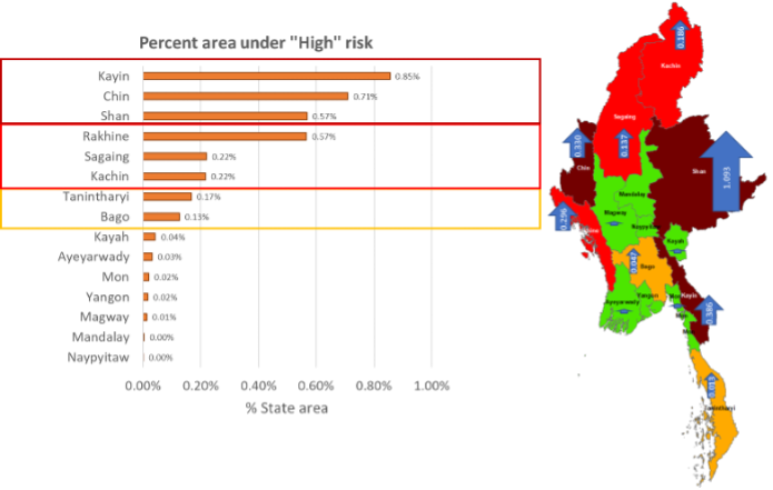
- The full-scale model is assembled and executed retrospectively for five consecutive years (2016-2020) at the specified in the requirements spatial (240m country wide with localized zoom in at 30m) and temporal (8-day) resolutions (Figure 1).
- Model coding is optimized to enable in-country operations with locally available computing resources.
- The alternative web-based system delivery platform has been established, and the team has completed historic runs (2016-2020) and initiated porting data into the WebGIS platform.
- Selected publications:
- Chen D, Shevade V, Baer A, et al. A disease control-oriented land cover land Use map for Myanmar. Data (Basel). 2021;6(6):63.
- Hoffman-Hall A, Puett R, Silva JA, et al. Malaria exposure in Ann Township, Myanmar, as a function of land cover and land use: combining satellite Earth observations and field surveys. Geohealth. 2020;4(12):e2020GH000299.
- Selected highlight:
- NASA (2020): Gathering On-the-Ground Data with Tatiana Loboda
Geographic scope: Republic of the Union of Myanmar
Earth observations: Multi-temporal Landsat imagery (Surface Water Fraction, Settlement mapping); MODIS land surface temperature (MOD/MYD11A2) and precipitable water (MOD/MYD07) datasets (downscaled to 240 & 30m resolution); Landsat-based existing publicly available datasets (Global Forest Loss, Global Impervious Surface, Global Fractional Tree & Bare Ground Cover); NASA-holdings of Very High Resolution imagery (to support baseline development)
Users: Duke Global Health Institute (DGHI), Myanmar