Cholera is an acute diarrheal infection, caused by the ingestion of food or water contaminated with Vibrio cholerae. It remains a significant global health risk, where 40-80 million people are living in cholera hotspots in Africa. The real burden of cholera, which is underreported between 1.4 and 4 million cases, hinders the ability to predict high-risk areas of cholera outbreaks in Africa. This project aims to integrate satellite data systems and validate a predictive model (Regional Cholera Prediction Modeling System) to produce weekly time steps for the epidemic and endemic models of cholera for Africa and work with international agencies to inform cholera risk reduction in Yemen and other African nations. It will also develop a comprehensive regional specific capacity building plan to engage end-users to incorporate this information into decision-making and facilitate the creation and implementation of appropriate intervention strategies (December 2020 Update).
Key highlights:
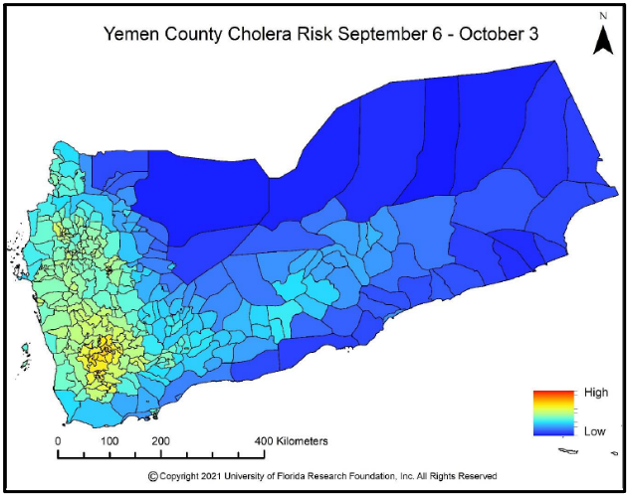
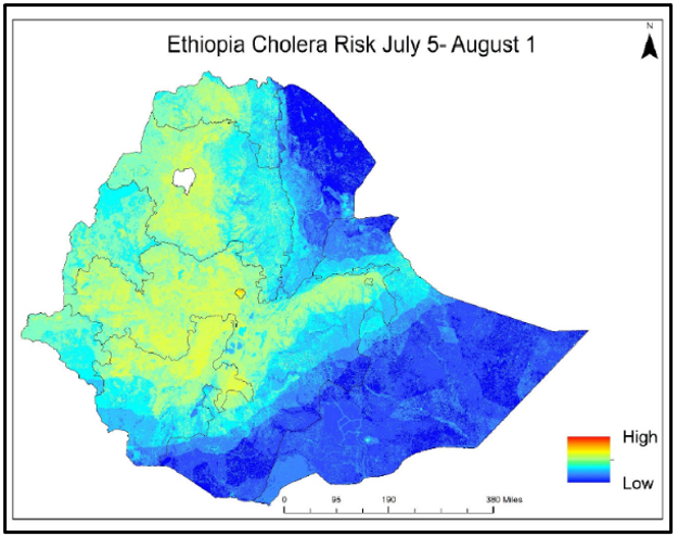
- The team has conducted weekly assessments of cholera risk in Yemen and Ethiopia (at request of end-users) and previous assessments of Mozambique (Figures 1-2).
- The Vibrio Prediction Hub, including a cholera risk map viewer, has been released, and the team is working to incorporate end-user feedback into the hub.
- There is confirmed operationality to project partners (UNICEF, Red Cross Climate Center, UN Office for the Coordination of Humanitarian Affairs, others) to inform cholera risk reduction in this geographic region.
- Country-specific user documents (Yemen) have been finalized and training sessions with UNOCHA and UNICEF have been organized for sustained use of the web-based application.
- The team is working on the development of the prototype of the Android App for the cholera trigger module.
- Selected publications:
- Usmani M, Brumfield KD, Jamal Y, Huq A, Colwell RR, Jutla A. A review of the environmental trigger and transmission components for prediction of cholera. Trop Med Infect Dis. 2021;6(3):147.
- Brumfield KD, Usmani M, Chen KM, et al. Environmental parameters associated with incidence and transmission of pathogenic Vibrio spp. Environ Microbiol. 2021;10.1111/1462-2920.15716.
- Selected highlights:
- NASA Earth Observatory (2020): Of Mosquitoes and Models: Tracking Disease by Satellite
- NASA Earth Observatory (2020): Predicting Cholera Risk in Yemen
- NASA (2018): NASA Investment in Cholera Forecasts Helps Save Lives in Yemen
Geographic scope: Africa (Algeria, Ethiopia, Zimbabwe, Sudan)
Earth observation data: MODIS/VIIRS air and ocean temperatures; GPM precipitation; MERRA-2 air temperature; ORNL LandScan population data
Users: United Kingdom Department for International Development (UK-DFID); Met Office (UK); United Nations Children’s Emergency Fund (UNICEF); United Nations Office for the Coordination of Humanitarian Affairs (UNOCHA); Red Cross Climate Center; AfriGEOSS