Portland Urban Development (Summer 2023)
Team: Keegan Kessler (Project Lead), Hadwynne Gross, Jordan Larson, Adam Nayak
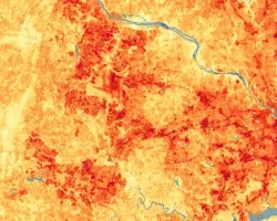
Summary: Urban heat is a pressing concern in Portland, Oregon as climate-change induced heat waves increase. Cities experience higher temperatures due to the urban heat island effect (UHI), and environmental injustice and disenfranchisement in minority communities expose low-income and Black, Indigenous, and People of Color (BIPOC) residents to more extreme and debilitating heat events. Our team identified Portland’s communities on the frontlines of urban heat impacts by overlapping environmental and social vulnerabilities using NASA Earth observations. We partnered with Depave, a Portland-based nonprofit that works alongside communities to replace pavement with greenspace in historically disenfranchised areas. Using Landsat 8 OLI and TIRS imagery, we mapped Land Surface Temperature (LST) and developed a heat-specific Social Vulnerability Index (SVI) through a Principal Component Analysis (PCA) to identify Portland’s communities with the highest potential heat vulnerability. Then, we calculated the temperature change of depaving in six case studies to quantify Depave's efforts in heat mitigation and environmental justice. Our analysis demonstrated that, throughout Portland, there are frontline communities experiencing high potential social vulnerability to extreme temperatures due to environmental injustices and over-pavement. Finally, Depave’s impact on urban heat is observable and quantifiable using remote-sensing data and tools, with an average of 1ºF decrease across the six case studies. We illustrated the significance of local urban heat mitigation efforts and propose next steps for conducting inclusive and intentional research that highlights the lived experiences and resilience of frontline communities.
Related Impact