Displaying 1 - 4 of 4
![Map showing southeast Los Angeles urban heat exposure around community locations identified by Research Leadership Academy participants.](/sites/default/files/styles/lis/public/2024-01/Douglas_EEJ.jpg.webp?itok=X2Hz9n30)
Topic
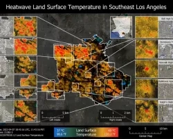
In partnership with Communities for a Better Environment, a community-based organization leading the advancement of zero-emission technologies and green infrastructure in environmental justice communities, our...
Topic
This project explores the potential of Remote Sensing (RS) and spatial data to advance Environmental Justice, with a focus on tribal land and water resources...
![Historic map of the Harbor used in this study.](/sites/default/files/styles/lis/public/2024-02/Nalley_image_0.PNG.webp?itok=kBqbMGaq)
Team: Sandy Ward (Mālama Puʻuloa) Donn Viviani (Leeward Community College) Mia Comeros-Raynal (Water Resources Research Center at the University of Hawaiʻi at Mānoa) Dingyi Liu...
![This example map from Hang’s project indicates MODIS land surface temperature over selected underserved communities in Atlanta in early 2005. This map was co-designed by residents from those communities that are concerned about the seasonal change of extreme weather, air pollution, accessibility to green space such as parks and Atlanta BeltLine. (Credits: Ethan Li and Yun Hang, Emory University)](/sites/default/files/styles/lis/public/2024-04/Hang%20Project%20Page%20Image.png.webp?itok=7MiGgISi)
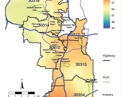
Team: Melanie Pearson (Emory University), Christine Ekenga (Emory University), Yang Liu (Emory University), Ethan Li (Emory University), Erin Lebow-Skelley (Emory University), Alina Merceron (Emory University)...