The Multi-angle Imaging SpectroRadiometer (MISR) instrument will provide a unique opportunity for studying the ecology and climate of Earth through the acquisition of global multiangle imagery on the daylit side of Earth. MISR views Earth with cameras pointed in 9 different directions. As the instrument flies overhead, each piece of Earth's surface below is successively imaged by all 9 cameras, in each of 4 wavelengths (blue, green, red, and near-infrared).
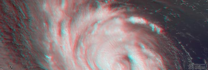
NASA's Multi-angle Imaging SpectroRadiometer (MISR) passed over Hurricane Florence as it approached the eastern coast of the United States on Thursday, September 13, 2018. At the time the image was acquired, Florence was a large Category 2 storm and coastal areas were already being hit with tropical-storm-force winds.
The MISR instrument, flying onboard NASA's Terra satellite, carries nine cameras that observe Earth at different angles. It takes about seven minutes for all the cameras to observe the same location. This stereo anaglyph shows a 3D view of Florence. You will need red-blue 3D glasses, with the red lens placed over the left eye, to view the effect. The anaglyph shows the high clouds associated with strong thunderstorms in the eyewall of hurricane and individual strong thunderstorms in the outer rain bands. These smaller storms can sometimes spawn tornadoes.
These data were captured during Terra orbit 99670. MISR data are available through the NASA Langley Research Center; for more information, go to https://eosweb.larc.nasa.gov/project/misr/misr_table. MISR was built and is managed by NASA's Jet Propulsion Laboratory in Pasadena, California, for NASA's Science Mission Directorate in Washington, D.C. The Terra spacecraft is managed by NASA's Goddard Space Flight Center in Greenbelt, Maryland. The MISR data were obtained from the NASA Langley Research Center Atmospheric Science Data Center in Hampton, Virginia. JPL is a division of Caltech in Pasadena.
Learn more about MISR: https://misr.jpl.nasa.gov/


