Two extra-tropical cyclones recently dropped very heavy rain over New Zealand, Debbie and Cook. As Cook's remnants continue to move away, NASA analyzed the heavy rainfall generated from the double extra-tropical punch.
Tropical cyclone Debbie dumped extreme amounts of rain over the northeastern coast of Australia when it hit the Queensland coast on March 28, 2017. After drenching northeastern Australia Extra-tropical Cyclone Debbie transported a river of water over New Zealand last week. Debbie's remnants dropped heavy rainfall that caused widespread flooding near the Bay of Plenty on New Zealand's northeastern coast. Thousands of residents needed to be evacuated with extra-tropical cyclone Debbie.
This week extra-tropical Cyclone Cook added to the recent unusually heavy rainfall over New Zealand. Tropical Cyclone Cook earlier killed one person and dropped a reported 300 mm (11.8 inches) when it hit New Caledonia first on April 10, 2017. New Zealand's Bay of Plenty and Hawkes Bay on the northeastern coast of the North Island were again the most affected by this second extra-tropical cyclone to hit New Zealand.
The Global Precipitation Measurement mission or GPM satellite, a joint mission between NASA and the Japanese space agency JAXA measures rainfall from space, and that data was used to calculate rainfall. GPM data was included in NASA's IMERG to tally the rainfall from both extra-tropical cyclones.
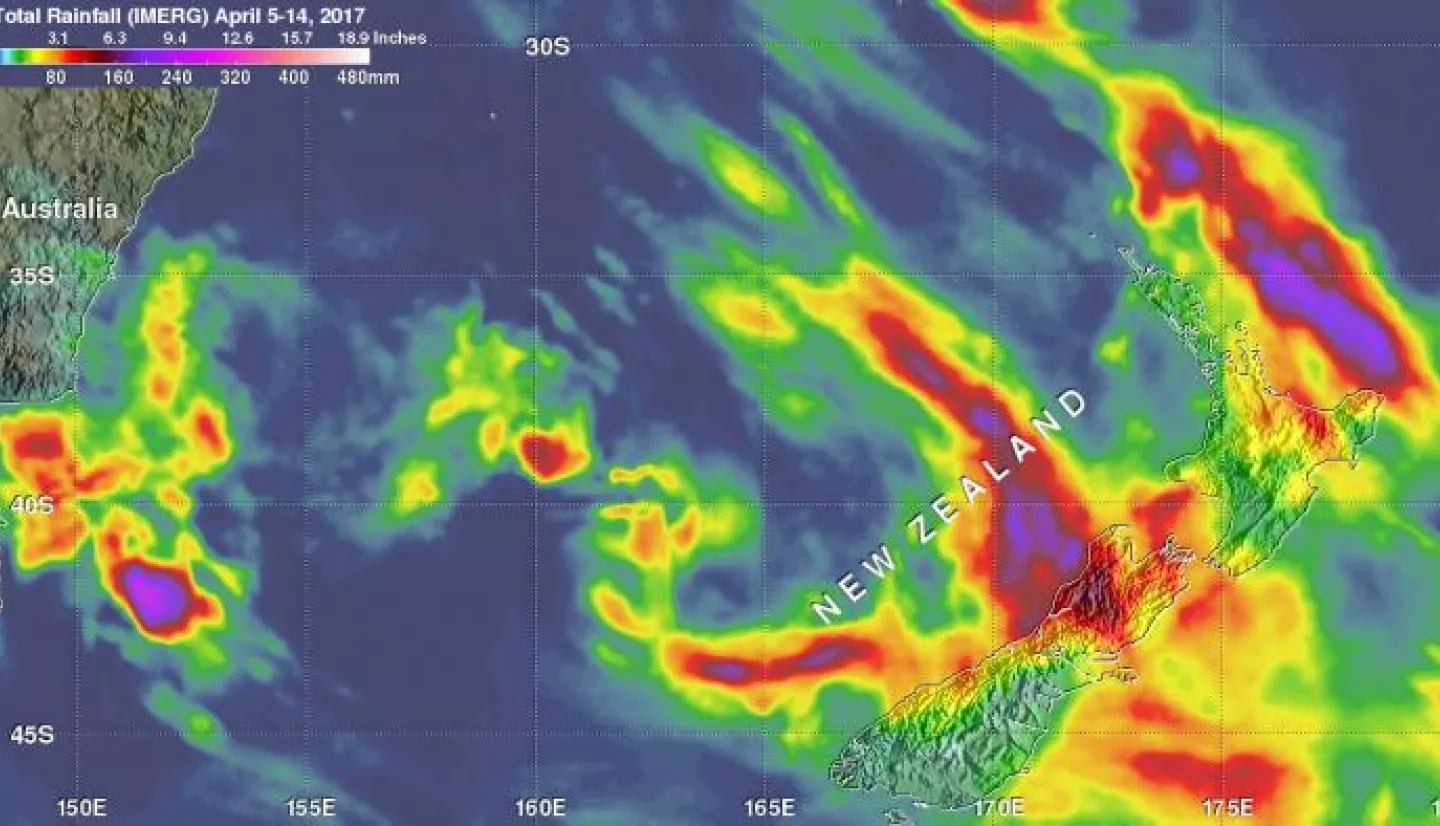
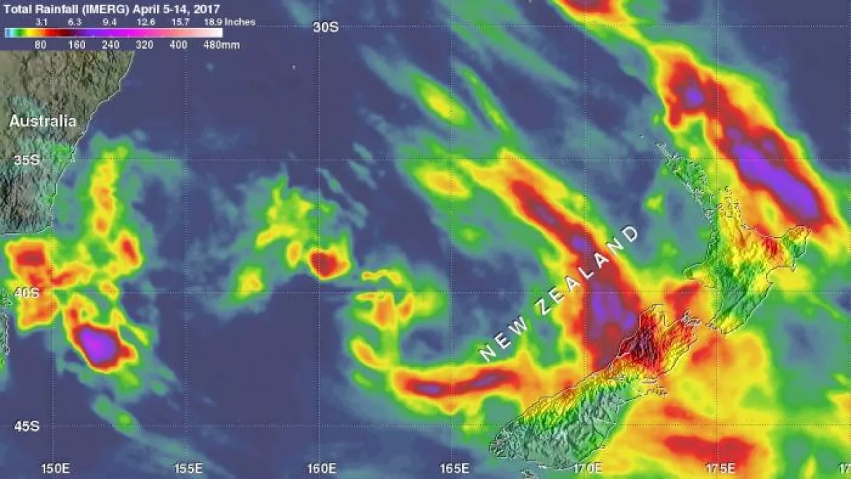
NASA's Integrated Multi-satellitE Retrievals for GPM (IMERG) data were used to estimate the total amount of rain that fell in the area from southeastern Australia through New Zealand. IMERG estimates of rainfall accumulation from April 5 to 14, 2017 were created at NASA's Goddard Space Flight Center in Greenbelt, Maryland using data from several satellites in the GPM constellation of satellites. Rainfall data was produced in near-real time at half hourly intervals from NASA's Integrated Multi-satellitE Retrievals for GPM (IMERG) data. The data were calibrated with measurements from the GPM Core Observatory as well as rain gauge networks around the world. IMERG rainfall totals have been adjusted to reflect observed values in other similar extreme rainfall events.
IMERG data indicates that rainfall totals of over 80 mm (3.1 inches) were common in many areas of New Zealand. IMERG shows that the two extra-tropical cyclones and other low pressure systems dropped heavy rainfall on both the North and South Islands of New Zealand. The IMERG rainfall analysis indicates that an area west of Wellington on the South Island received some of the heaviest rainfall during this period.
On April 14, the New Zealand Metservice issued a Severe Weather Watch for Buller, Westland
The bulletin stated "[Extra-Tropical] Cyclone Cook has now moved southeast of New Zealand, but heavy rain about Westland and Buller continues until early Saturday [April 15].
Cyclone Cook has now moved away to the southeast of New Zealand, and the threat of severe weather for the southeast regions of the South Island has now passed. However, warning amounts of rain are still possible for the ranges of Buller and Westland.
This Watch is for the possibility of rainfall amounts reaching warning criteria about THE Ranges of Buller and Westland until early Saturday morning. The Watches for heavy rain have now been lifted for North Otago, Dunedin and Clutha. Also, the Watches for severe gale winds for Banks Peninsula, North Otago, Dunedin and Clutha are also now lifted. This Watch will be reviewed by 9:30am Saturday April 15."
For updated warnings and watches from the New Zealand Met Service, visit: http://www.metservice.com/warnings/home
Instrument / Model: IMERG


