Imagen
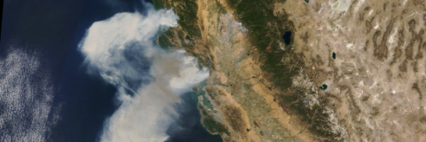
Fast burning wildfires broke out this week in California, forcing thousands to evacuate. So far, the fire has consumed thousands of acres of land and destroyed property.
Remote sensing can be used to monitor wildfires, classify land in its path, track smoke and ash, and monitor post-burn scars.
These trainings can help you learn about applying remote sensing for wildfires:
Level 1
Introduction to Remote Sensing for Wildfire Applications
5 hours
Level 2
Application of Satellite Remote Sensing Data for Fire & Smoke Monitoring
Materials Only
Level 1
NASA Earth Science Data for Wildland Fire Decision Making
Some Materials Available
These tools are helpful for monitoring and tracking fires, and have been covered in ARSET trainings:


