
Vermont’s Lake Champlain provides drinking water for nearly a quarter-million people, and it’s a rich ecosystem that supports a thriving sport-fishing industry – and even, according to legend, a sea monster named Champ.
Today, that ecosystem is under threat from a different, and real, kind of monster – harmful algal blooms (HABs). NASA used satellite data to determine where and when algal blooms occurred in the lake to help Vermont officials raise awareness of water quality issues, inform land and water management policies and develop an early-warning system to protect public health.
HABs are triggered by excessive amounts of phosphorus flowing into Lake Champlain from agricultural and urban pollution around the lake’s watershed. These blooms can produce toxins that make the area unsafe for swimming or fishing. They create “dead zones” where marine life succumbs to the toxins or loss of oxygen. And these blooms also increase the cost of water treatment for the communities around the lake.
Traditionally, citizen volunteers have helped identify and track harmful algal blooms in Lake Champlain by collecting water quality samples in various parts of lake. This process requires a large number of volunteers, however, and it doesn’t test the water quality for the entire lake.
In collaboration with NASA DEVELOP, the Vermont Department of Environmental Conservation (DEC) partnered with the Lake Champlain Committee (LCC) and the Lake Champlain Basin Program (LCBP) to find a more complete way to locate and track HABs around the lake.
NASA’s Earth Applied Sciences DEVELOP program spearheads strategic partnerships that seek solutions to environmental and other Earth science issues. LCC is a citizen-based nonprofit founded by people in Vermont and New York who advocate for environmental protection for the lake. LCBP is administered by federal and state agencies in Vermont, New York and Québec, working with private organizations and local communities and individuals to protect the Lake Champlain Basin’s water quality, resources and fish and wildlife.
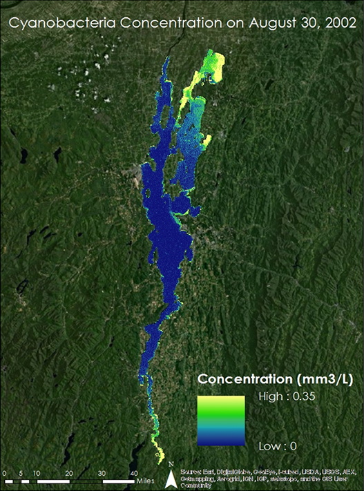
For this project, the DEVELOP team brought Earth-observing data into the mix to monitor changes in the cyanobacteria’s blue-green hue. With this data, the team tracked the occurrence of algal blooms from the previous 12 years around all of Lake Champlain.
Then the team used satellite imagery to construct a time series for identifying long-term HABs trends. Team lead Patrick Faha explained, “[The satellite] records an image of the lake daily, which is beneficial for observing blooms which occur on timescales of hours to days.” With these images, the team calculated a “cyanobacterial index” and created maps to determine where and when past HABs occurred.
“We compared these results with precipitation and temperature data – as well as in situ phosphorus measurements – to see if these had any effect on when and where the blooms occur,” Faha added. The team also used the U.S. Department of Agriculture’s (USDA) National Agriculture Imagery Program data to track long-term changes in Vermont’s landcover over the previous 12 years. After piecing the images together, the team created a land cover image showing changes in urbanization and agriculture around the lake. When the project wrapped, DEVELOP gave the data and maps to its partners.
“The NASA … project helped me personally better understand the capabilities of remote sensing at this level – as well as the limitations. It is one more tool to help us understand and explain a very complex biological community.”
–Angela Shambaugh, Vermont Department of Environmental Conservation
“[The project data] was shared internally to raise awareness of the extent of blooms on the lake beyond our typical monitoring locations as well as the highly dynamic nature of blooms on this larger scale,” said Angela Shambaugh, an environmental scientist at Vermont’s DEC. “The NASA … project helped me personally better understand the capabilities of remote sensing at this level – as well as the limitations. It is one more tool to help us understand and explain a very complex biological community.”
Because of its work with DEVELOP, DEC was invited to participate in the Cyanobacteria Assessment Network (CyAN), another partnership project with NASA’s Applied Sciences Program, the National Oceanic and Atmospheric Administration (NOAA), the U.S. Environmental Protection Agency (EPA), and the U.S. Geological Survey (USGS).
CyAN’s goal is to develop an early warning system for algal bloom detection in America’s freshwater bodies to protect aquatic and human health. For Shambaugh, the new capabilities that CyAN provides to DEC are promising. “The data are already indicating that cyanobacteria bloom frequency does appear to be increasing in Champlain,” she said. “It’s a key piece of information as we work on the ground to raise awareness of water quality issues, formulate policy, and require best management practices.”
This story is part of our Space for U.S. collection. To learn how NASA data are being used in your state, please visit nasa.gov/spaceforus.


