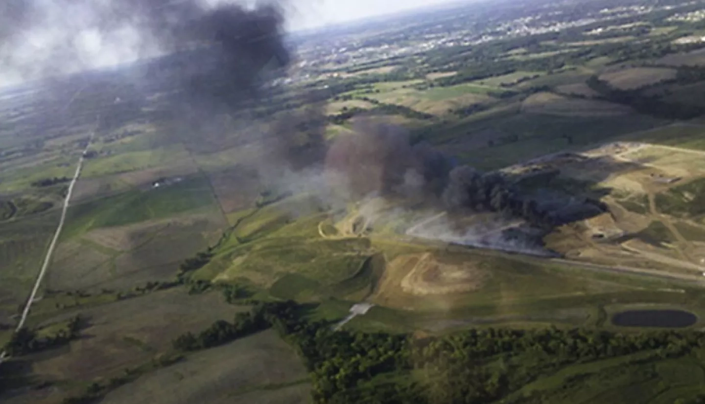
Located on the eastern edge of Tornado Alley, the Hawkeye State sees its share of severe weather. In May 2012, however, there was an altogether different type of black cloud roiling menacingly in Iowa City’s western sky. It was the toxic plume of a landfill fire, ignited on Saturday, May 20, 2012 – just a few miles west of Iowa City.
To monitor the hazardous smoke plume and predict its impacts, NASA worked with local experts to implement a new toxic plume forecasting system based on NASA satellite observations. NASA released the first plume forecast within 72 hours of the fire, which officials used to improve their response efforts.
Fueled by a new landfill liner composed of more than 1 million shredded tires, the blaze grew quickly and burned for more than two weeks, releasing a continuous, toxic cloud over the region.
Almost immediately after the fire erupted, Scott Spak, who happened to live in Iowa City, gathered a crew of collaborators to monitor the hazardous smoke plume and predict its effect on the community. Spak is a principal investigator for NASA’s Air Quality Applied Sciences Team, which later became HAQAST.
“Within three hours of the first report of the uncontrolled fire, [the group] began continuous monitoring of fine-particle mass and composition at a permanent site on the University of Iowa [UI] campus, about 2 miles (3.22 kilometers) from the fire,” Spak said. Shortly after, the team coordinated with the State Hygienic Laboratory at UI to formulate its strategy. By the following Tuesday, “we had planned a complete campaign,” Spak added.
Their campaign implemented a new and enhanced plume forecasting system that uses satellite observations to augment mathematical tools called “models” that help predict the concentration of particulate air pollutants. Driven by the Weather Research and Forecasting model (WRF), the standard model is called AERMOD. For this landfill fire, however, the team also assimilated data from the Moderate Resolution Imaging Spectroradiometer (MODIS) instrument on NASA’s Terra satellite.
“I quickly created a forecast system based on the WRF and the AERMOD dispersion model, and produced the first plume forecast within 72 hours of the fire,” noted Spak. This novel forecasting technique offered two improvements over the traditional air-dispersion modeling system.
“This application of satellite data was especially important because the impacts of cloud cover were among the most uncertain parameters for the short-term plume forecast.”
–Scott Spak, NASA Air Quality Applied Sciences Team
“First, we used MODIS AOD [Aerosol Optical Depth] and visible imagery to track the plume from the landfill fire … Secondly, and far more importantly, we employed MODIS cloud retrieval data to initialize the WRF forecast,” Spak explained. “This application of satellite data was especially important because the impacts of cloud cover were among the most uncertain parameters for the short-term plume forecast.” Cloud cover can significantly impact things like air temperature, wind speed, and other atmospheric phenomena that affect how a smoke plume behaves.
Along with developing this improved forecasting system, the project team used mobile air-quality monitors to sample the landfill plume for toxic aerosols and gases. This allowed them to get detailed readings from a variety of locations in the plume’s path.
The team relayed its forecasts to Johnson County Public Health and Johnson County Emergency Management, which used them to support public health messaging and planning. Officials were concerned about whether they would have to order an immediate local evacuation due to high particulate matter and toxic gas concentrations. Fortunately, that wasn’t the case.
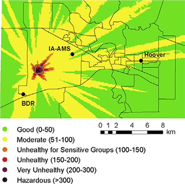
“Our forecast resolved the lower concentrations and AQI [air quality index] needed to support less urgent public health messaging … such as whether to cancel outdoor activities at area schools, or public outdoor events, including the Summer of the Arts Festival,” Spak said. In fact, the AQAST forecast indicated the high concentrations of particulates would dissipate before the festival. The forecast was verified, and the festival went on as scheduled.
By early June, fire crews contained the landfill fire; the AQAST team provided forecasts throughout. Based on the team’s forecasts and feedback, officials have implemented improvements in their response efforts.
“The Iowa City landfill [staff] now plans and conducts annual exercises to prepare for fires and hazmat incidents … and the Iowa State Hygienic Laboratory [staff] has changed its sampling strategy and monitoring plans for tire and landfill liner fires,” noted Spak.
This news should allow all Iowans to breathe a (toxic-free) sigh of relief.
In the fall of 2016, AQAST expanded to become the Health and Air Quality Applied Sciences Team (HAQAST).
This story is part of our Space for U.S. collection. To learn how NASA data are being used in your state, please visit nasa.gov/spaceforus.


