Regular bouts of dryness and wildfires make Idaho, with its picturesque rough terrain and shrubby steppes, especially vulnerable to wildfires. The 2015 wildfire season was a record for the U.S. as a whole, and in Idaho, which suffered its worst fire season in nearly 90 years, the Soda Fire was one of the largest.
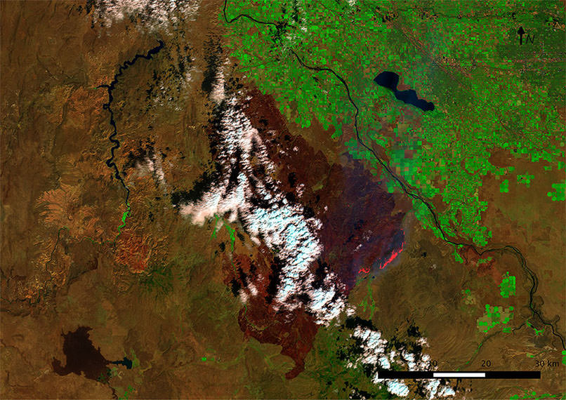
Ignited by a lightning strike on August 10, 2015, the Soda Fire burned across the rugged landscape of southwest Idaho and eastern Oregon. Feeding on sagebrush, cheatgrass and mountain mahogany, the fire expanded quickly, from 78,000 acres (316 square kilometers) on the morning of August 12, to 120,000 acres (486 square kilometers) by that afternoon.
When Keith Weber heard about the fire’s quick growth, he knew what lay ahead. Weber is the director of the Idaho State University Geographic Information System (GIS) Training and Research Center. For previous fires, Weber's team partnered with the Boise District of the U.S. Department of the Interior’s Bureau of Land Management and helped facilitate using satellite data for post-fire rehabilitation even during active firefighting efforts. “This fire was an unusual one,” Weber remarked. “One of those rapidly moving mega-fires that can be very problematic.”
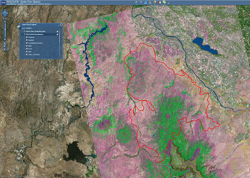
As the fire quickly expanded, Bureau of Land Management needed immediate access to near-real-time data on the fire’s extent and recent impacts, so its Emergency Stabilization and Rehabilitation team could quickly assess fire damage and identify areas for rapid treatment and restoration. That information came from a mapping system developed by Weber called the Rehabilitation Capability Convergence for Ecosystem Recovery (RECOVER).
“The land management agencies were doing all the work to fight the fire,” Weber said. “What we were doing was supporting them so they could make good decisions quickly about how to fight the fire and, later, how to manage the land after the fire.”
A joint project of the NASA, the Bureau of Land Management and Idaho State University, RECOVER provides information for rapid remediation during and after wildfires using already-existing satellite data. It does this by creating a single tool that automatically integrates many data and imagery layers, including current and archived satellite land and infrared image data. The RECOVER system assembles and superimposes the information on top of imagery of burned and burning areas to produce near-real-time updates in an easy-to-use interface, accessible on a standard web browser.
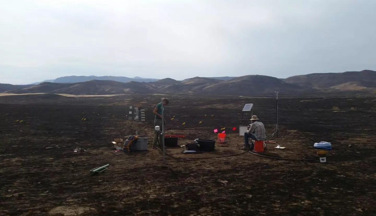
RECOVER gathers up to 20 different datasets – including wildlife habitat and local topography – into one system that helps BLM rehabilitation crews assess the situation more completely and quickly. Before this, remediation crews would have to wait for the fire to be contained and then complete an assessment before submitting a rehabilitation plan. The assessment would include surveying multiple websites for information on soil layers, plant species composition, burn severity mapping, and other data, according to Gregory Mann, a fire ecologist with BLM.
“RECOVER supported our early rapid assessment for rehabbing after the fire even while firefighters were still on the ground.”
–Karen Miranda, Emergency Stabilization and Rehabilitation Team
That process of collecting information was typically challenging and time-consuming – often taking several days to more than a week to complete. “When we’re dealing with large fires, it’s extremely difficult,” Mann added.
The massive Soda Fire ultimately burned more than 283,000 acres (1,145 square kilometers) across Idaho and Oregon. Crews using RECOVER were able to automatically generate and refresh data while the fire was still actively burning – something that wasn’t possible before. In fact, by the time the wildfire was contained, rehabilitation crews already had a complete and ready-to-use customized analysis of the Soda Fire.
With that data at their fingertips in a matter of minutes, the teams could promptly determine where to target their rehabilitation efforts. “RECOVER supported our early rapid assessment for rehabbing after the fire even while firefighters were still on the ground,” Karen Miranda, information officer for the Emergency Stabilization and Rehabilitation team said. “Pre-planning before the fire is fully contained helps our work move forward as quickly as possible.”
This story is part of our Space for U.S. collection. To learn how NASA data are being used in your state, please visit nasa.gov/spaceforus.


