Displaying 441 - 450 of 466
![Kernel density distributions of census tract-level cooling degree days from May through September 2013 in Fahrenheit by race/ethnicity across the climate regions of New York State. Cooling degree days are calculated with a threshold of 65°. White = Non-Hispanic White, Hispanic = Hispanic/Latino of any race, Black = Non-Hispanic Black, Asian = Non-Hispanic Asian.](/sites/default/files/styles/lis/public/2023-10/Carrion%20Project%20Page%20Image.png.webp?itok=yyxxauFg)
Identifying temperature disparities, energy insecurity, and social vulnerability for energy justice in New York State Team: Daniel Carrión (Yale School of Public Health), Anna Stouffer...
![A map of the community, La Margarita, which is a municipal neighborhood of Salinas, Puerto Rico. The map outlines the location of La Margarita in proximity to the wider city of Salinas, as well as natural areas of interest.](/sites/default/files/styles/lis/public/2023-11/Flynn%20Project%20Page%20Image.png.webp?itok=YW0ujn6p)
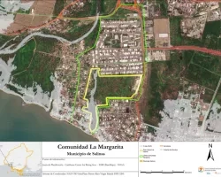
Leveraging Earth Observation Data to Support Environmental Justice: A Puerto Rico Coastal Community Case Study Team: Dr. Stephen Flynn (GRI), Fernando Pabon Rico (PRSTRT)...
![Visible (eye-level) green exposure in Camden and Jersey City, NJ.](/sites/default/files/styles/lis/public/2023-11/Meenar%20Project%20Page%20Image.jpg.webp?itok=AZ-7EFUS)
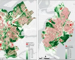
The Project GrEEEn: Utilizing an environmental justice lens and earth science data to enhance greenspace Equity, Exposure, and Experience Team: Dr. Mahbubur Meenar (Rowan University)...