Volcanic ash clouds pose a great danger to air traffic safety, leading to flight cancellations and creating a ripple effect on the airline industry’s economy. Real time satellite observations can provide crucial information for re-routing air traffic around the hazardous volcanic clouds. Nickolay Krotkov’s A.37 project, “Day-Night Monitoring of Volcanic SO2 and Ash for Aviation Avoidance at Northern Polar Latitudes: Enhancing Direct Readout Capabilities from EOS, SNPP, and NOAA20,” aims to critically improve direct-readout (DR) satellite products to monitor volcanic ash clouds and forest fire smoke plumes.
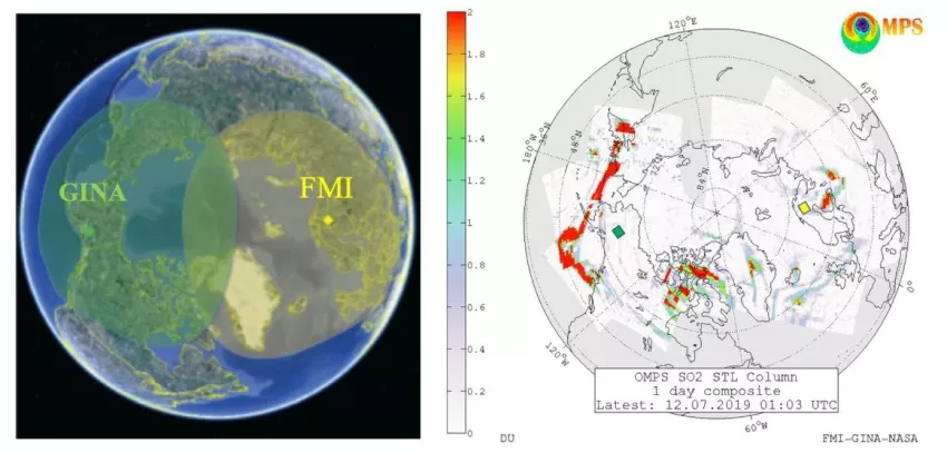
This project addresses the need to serve the increasing number of flights that operate at night or fly over polar regions by developing DR volcanic ash and sulfur dioxide (SO2) products based on solar backscatter UV and thermal infrared data. The team established partnerships between the Geographic Information Network of Alaska (GINA), USGS Alaska Volcano Observatory (AVO), Anchorage Volcanic Ash Advisory Center (VAAC), NASA’s Jet Propulsion Laboratory, NASA’s Direct Readout Laboratory (DRL), NASA’s Ozone Processing Team, and the Finnish Meteorological Institute (FMI) to locally process satellite volcanic ash and SO2 data at GINA and FMI for distribution to several end users. The use of high latitude ground stations processing DR data from operational meteorological polar orbiting satellites, each with several overpasses over the polar region, provides real-time coverage of all high-latitude volcanoes in the Northern Hemisphere.
Full Description
The dangers that volcanic ash clouds pose on inflight air traffic safety can lead to prolonged flight cancellations that have a ripple effect on the airline industry’s economy and personal travel. Low-latency satellite observations provide crucial information for rerouting air traffic around volcanic clouds. During a previous Applied Sciences Program project our team established partnerships between the Geographic Information Network of Alaska, NASA’s Direct Readout Laboratory, NASA’s ozone processing team and the Finnish Meteorological Institute so as to locally process ultraviolet-based (UV) direct-readout (DR), satellite-observed volcanic ash and sulphur dioxide (SO2) data for distribution to a number of end users.
The UV-based monitoring is unavailable at night or under low-light conditions, so users have requested that we expand the DR monitoring capabilities to better serve the ever-increasing number of flights that operate at night or fly over polar regions. Here, we will address this critical need by developing DR volcanic ash and SO2 products based on thermal infrared data acquired by several satellite-borne instruments.
We will also critically improve and extend our DR-UV products to monitor smoke plumes from forest fires. These new products will be evaluated and assessed by several organizations, including the National Weather Service and the Alaska Volcanic Ash Advisory Center. Our collaborators from the Finnish Meteorological Institute will evaluate the DR plume products for use in the northern Atlantic, Norwegian, Barents and Kara Seas, and distribute them to European users.
The combined use of high latitude direct-readout stations stations and multiple polar satellite platforms, each with several daily overpasses over the polar region, will provide low-latency coverage of all high-latitude volcanoes in the Northern Hemisphere.