Francis Monaldo’s A.37 project, “Development and Implementation of Remote Sensing Techniques for Oil Spill Monitoring and Storm Damage Assessment in an Operational Context,” is collaborating with the National Oceanic and Atmospheric Administration (NOAA) to improve the algorithms that identify the United States’ coastal oil spills.
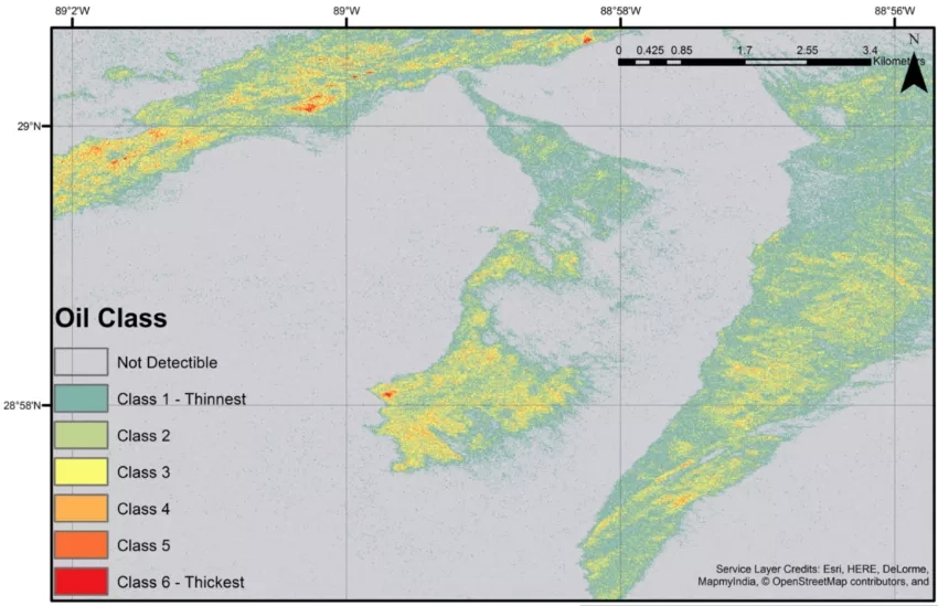
The project uses Synthetic Aperture Radar (SAR) along with traditional Earth observation platforms to automatically detect and characterize oil thickness using a “contrast ratio” algorithm. As crude oil spreads and becomes thinner, it changes from black or brown to an iridescent or silver sheen. The “Marine Oil Spill Thickness,” or MOST product, compares the extent of a SAR image brightness reduction in oil-covered areas with open water to assess and classify thickness. These MOST products will be delivered through NOAA to enable rapid situational assessment and an optimized deployment of rescue and oil remediation and recovery resources. Monaldo’s project works to improve post-storm assessment of offshore oil and gas production facilities and marine debris while implementing new algorithms and databases in a semi-automatic system that NOAA can use to detect and assess oil spills and post-storm offshore damage and debris.
Full Description
The National Oceanic and Atmospheric Administration (NOAA) is responsible for monitoring coastal U.S. waters for accidental and deliberate oil spills, as well as for the emergency response and environmental assessment and restoration following such events. In addition, in the aftermath of severe storms, NOAA assesses the status of and potential damage to offshore platforms and pipelines, which are potential sources of significant oil leaks and marine debris. All-weather and high-resolution data from the enlarging set of spaceborne synthetic aperture radars (SARs) and high-resolution optical satellites offer an important opportunity for NOAA to exploit remote sensing for automated oil spill response and remediation and post-storm offshore infrastructure assessment.
Our work supports the hurricane/tropical cyclone primary hazard scenario with cascading risks, focusing on semi-automated oil-spill characterization that can direct response to areas with more oil; health status assessment of offshore platforms, especially small uncrewed ones; and identification of marine debris. Marine technological hazards are also addressed.
Our work is intended to:
- Develop and mature automated oil spill detection and thickness estimates from SAR and optical imagery, based on focused field testing combined with in situ oil sampling, and incorporation of new sensors;
- Improve post-storm assessment of offshore oil and gas production facilities and marine debris; and
- Implement new algorithms and databases in a semi-automatic system that NOAA uses operationally to detect and assess oil spills and post-storm offshore damage and debris.
These products will be delivered through NOAA to enable rapid situational assessment and an optimized deployment of rescue and oil remediation and recovery resources.
We anticipate SAR instrumentation will provide a greater quantity of open data and more frequent coastal ocean imaging. For operational use, the data must be rapidly processed into products delivered to analysts, first responders, and people planning recovery and restoration efforts. It is critical that NOAA develop a validated assessment of the capabilities of the newer high-resolution sensors under different environmental conditions and for different oil properties in order to use them operationally for oil spill remediation. Combined oil extent and thickness products using all available data, both SAR and optical imagery, can provide significant improvements in both latency and reliability.
For post-storm assessment of the marine environment, there is also a need for a validated detection database of offshore platforms as a function of wind speed and sensor mode and type to support existing algorithms for the detection of offshore platforms and ships from remote sensing data. In a post-storm environment, this database will be used to assess whether the platform has actually moved or been destroyed or is simply undetectable in the given meteorological conditions. Similar well-understood relationships are needed between marine debris object size and detectability.