Visceral leishmaniasis (Lutzomyia longipalpis) and Aedes aegypti borne arboviruses (dengue, zika, chikungunya) have potential for epizootic spread from Latin America and the Caribbean and establishment in North America. This project aims to develop and implement a geospatial surveillance and response system data resource for vector-borne diseases in the Americas using NASA satellite and public health surveillance data, geographic information systems, and ecological niche modeling. The objective is to characterize the environmental suitability and potential for spread of selected endemic and epizootic vector-borne diseases in the Americas, with an initial focus on visceral leishmaniasis in Brazil. This project will also offer a geospatial health resource data portal with training courses for researchers interested in mapping and modeling other vector-borne diseases.
Key highlights:
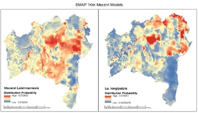
- Findings demonstrated that SMAP and VIIRS LST monthly time series satellite data can be used in lieu of classical Worldclim2 data to drive ecological niche models on risk of visceral leishmaniasis and its sand fly vector (Lutzomyia longipalpis) and guide control programs in two municipalities (Bahia, São Paulo) in Brazil (Figure 1).
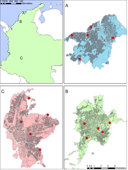
- The team has compiled temperature data from dataloggers indoors and outdoors, at weather stations and from satellites (Landsat), for three cities in Colombia and are currently compiling the ECOSTRESS satellite readings to complete the dataset (Figure 2).
- A one-week course module content of a second manual is being developed to train and implement operational results on visceral leishmaniasis and Aedes-borne diseases at the state level (1km) and municipality health unit level (70m/30m).
- Selected publications:
- Fonseca EDS, Guimarães RB, Prestes-Carneiro LE, et al. Predicted distribution of sand fly (Diptera: Psychodidae) species involved in the transmission of Leishmaniasis in São Paulo state, Brazil, utilizing maximum entropy ecological niche modeling. Pathog Glob Health. 2021;115(2):108-120.
- de Santana Martins Rodgers M, Bavia ME, Fonseca EOL, et al. Ecological niche models for sand fly species and predicted distribution of Lutzomyia longipalpis (Diptera: Psychodidae) and visceral leishmaniasis in Bahia state, Brazil. Environ Monit Assess. 2019;191(Suppl 2):331.
- Malone JB, Bergquist R, Martins M, Luvall JC. Use of geospatial surveillance and response systems for vector-borne diseases in the elimination phase. Trop Med Infect Dis. 2019;4(1):15.
Geographic scope: North and South America (Brazil, Colombia)
Earth observation data: VIIRS/MODIS; Landsat; ASTER; Worldview2,3; GPM; GOES-16; SRTM; SMAP; ECOSTRESS; GEDI
Users: Health agencies in the Americas; Sao Paulo State University (UNESP); Adolfo Lutz Institute; Federal University of Bahia (UFBA); University of Antioquia (UA); Federal University of Uberlandia (UFU); Butantan Institute