Hail is the costliest severe weather hazard for the insurance industry, damaging assets such as homes, businesses, agriculture, and infrastructure. Since most insurance companies do not reserve enough capital to cover catastrophes, they require reinsurance – insurance for insurance companies. The reinsurance industry uses catastrophe models (CatModels) to statistically estimate risk to an insurer’s portfolio.
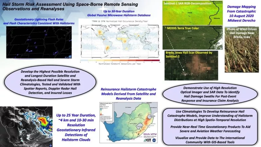
Kristopher Bedka’s A.37 ROSES Project, “Hail Storm Risk Assessment Using Space-Borne Remote Sensing Observations and Reanalysis Data,” uses NASA satellite data and capabilities to create a framework for developing continental to global scale hail climatologies and CatModels. The project – a collaboration between NASA’s Langley Research Center and NASA’s Marshall Space Flight Center, Willis Towers Watson (WTW) reinsurance, partners in Brazil and Argentina, and academic partners throughout the United States – seeks to mitigate hail disasters through aiding the development of new satellite-based severe storm nowcasting tools by regional partners and developing climatologies to improve societal understanding of hail frequency. The team is also demonstrating new ways for using land surface imaging satellite data to map severe storm damage and aid disaster response. The project team will demonstrate nowcasting capabilities with NASA datasets and provide training to partners to help them adopt these methods to improve warnings and mitigate disasters.
Full Description
Much of the world is impacted by severe thunderstorms, but whether they become disasters depends upon resilience: the capacity to prepare, mitigate, respond, and recover. Hail is the costliest severe weather hazard for the insurance industry, generating ~70% of severe convective storm losses in 2017 due to damage to assets such as homes, businesses, agriculture, and infrastructure. Most insurance companies do not reserve enough capital to cover catastrophes, so they acquire reinsurance. The reinsurance industry uses catastrophe models (CatModels) to statistically estimate risk to an insurer’s portfolio.
This project will create a framework for developing continental to global hail climatologies and CatModels based on NASA satellite data and capabilities. This is a collaboration between NASA’s Langley Research Center and NASA’s Marshall Space Flight Center, Willis Towers Watson (WTW) reinsurance, and partners in Brazil and Argentina. This project seeks to mitigate hail disasters over South America by aiding development of new satellite-based severe storm nowcasting tools by regional partners and developing climatologies to improve societal understanding of hail frequency.
Work with WTW will improve socioeconomic resilience through development of new CatModels. Southern Brazil, Uruguay, Paraguay, and Argentina feature some of the most intense thunderstorms on Earth. South America is a developing insurance market of interest to WTW clients and is similar to other regions routinely impacted by hail that do not have comprehensive hail reporting or radars to assess hailstorm frequency.
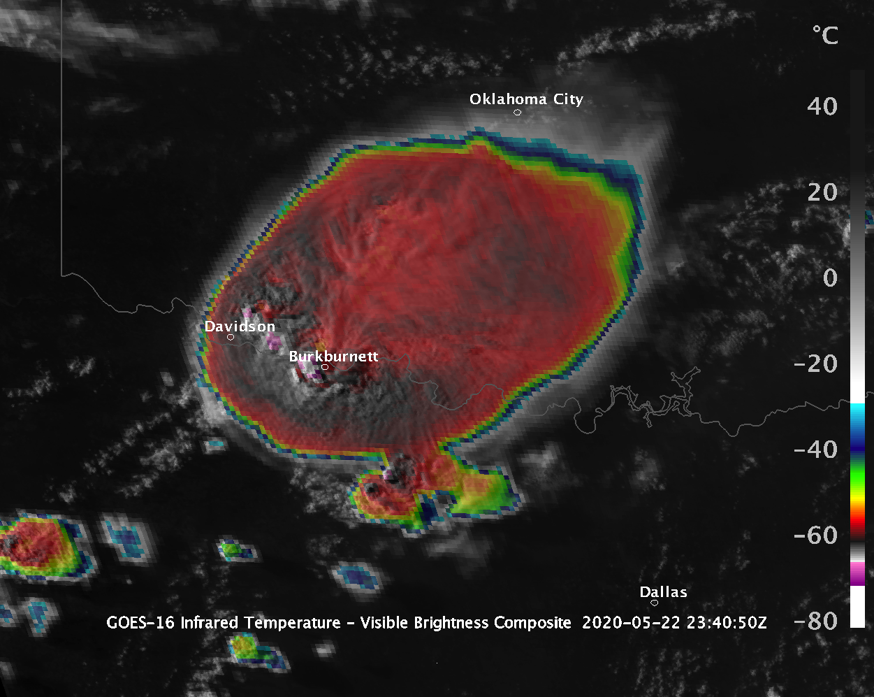
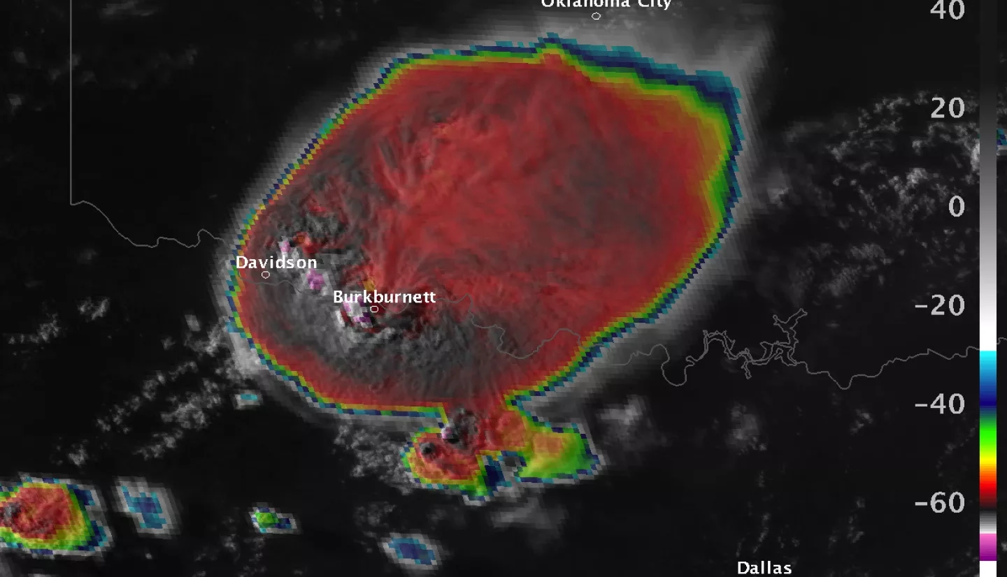
Historical low Earth orbit and geostationary Earth orbit imagery and reanalysis data will be used to detect hailstorms and estimate their severity. Global lightning mapper data will be used to further improve hailstorm analyses. We will mature land surface imaging satellite methods for identifying hail damage to aid disaster mapping. Few satellite-based severe storm nowcasting methods have been developed to serve South America. The project team will demonstrate nowcasting capabilities with NASA datasets and provide training to regional partners to help them adopt these methods to improve warnings and mitigate disasters.