Displaying 1 - 10 of 78
![Impervious surface imagery derived from Landsat 9 OLI-2 data. This composite was captured over the Finger Lakes region between April and October of 2022. Blue hues indicate dense vegetation while yellow hues indicate impervious areas. Areas in green indicate agricultural fields of interest to NGOs in the region that aim to prevent the conversion of agricultural lands to urban development.](/sites/default/files/styles/lis/public/2024-01/2023Sum_PUP_NewYorkEco_WebsiteImage.jpg.webp?itok=gjo4ogVR)
New York Ecological Conservation (Summer 2023) Team: Sam Schulteis (Project Lead), Sam Haas, Stephanie Willsey, Oliver Wilson Summary: Farmland provides ecosystems and communities with services...
![Landsat 8 OLI derived MNDWI imagery mosaicked from October 17, 2020, to December 2, 2020. Located near the Río Patuca (Patuca River) in Ahuas, Honduras, permanent water and flood is represented as bright red and orange while blue depicts other land cover types and clouds. Examining floods from disasters like Hurricanes Eta and Iota helps decision makers improve mitigation and response efforts.](/sites/default/files/styles/lis/public/2022-03/2021Fall_MSFC_CentralAmericaDisasters_WebsiteImage.png.webp?itok=pweSILBO)
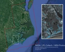
Central America Disasters (Fall 2021) Team: Caroline Williams (Project Lead), Lauren Carey, Maria De Los Santos, Deanna Fanelli, and Payton Ireland Summary: In November 2020...