The International Day for Disaster Risk Reduction was started in 1989 after a call by the United Nations General Assembly for a day to promote a global culture of risk-awareness and disaster reduction. Held every October 13, the day celebrates how people and communities around the world are reducing their exposure to disasters and raising awareness about the importance of reining in the risks that they face.
NASA’s Earth Applied Sciences Disasters Program works to facilitate disaster risk reduction by promoting access to Earth observations and by increasing the use and utility of data that inform choice, support decisions, and guide actions that prevent disasters, reduce risk and strengthen resilience
The Disasters Program acts as an enabler by investing in applied research and engaging with partners and stakeholders to pilot and demonstrate operational uses of Earth observations. The program takes a multi-hazard and systems approach that can increase situational awareness to protect lifelines. In particular, NASA leverages a comprehensive fleet of satellites, airborne instruments and ground systems, along with subject matter experts, to assess disaster impacts on society. NASA also provides free and open data, mapping products and decision tools. Success is measured by improving resilience to hazards, vulnerability and exposure, while strengthening coping capacity.
Engagement and collaboration are key practices where NASA facilitates dialogue and action among regional institutions globally. Two mechanisms to highlight include leadership roles in the Committee of Earth Observation Satellites (CEOS) Disasters Working Group, the Group on Earth Observations (GEO) Disaster Risk Reduction (DRR) Working Group and the AmeriGEO Disasters Working Group. Created in early 2020, the GEO DRR working group aims to develop and implement a coherent and crosscutting approach within GEO to advance the use of Earth observations in support of countries’ disaster risk reduction and resilience efforts. Coordinated with GEO leadership in Colombia, AmeriGEO works in North, South and Central America on GEO Initiatives and programs in disasters, agriculture, health, water, biodiversity and ecosystems, and the use of Earth observations for decision-making in general.
The Disasters Program also works to achieve the goals of the Sendai Framework for Disaster Risk Reduction. The Sendai Framework expresses the need to better understand the disaster risk in all its dimensions relating to exposure, vulnerability, and hazard characteristics; strengthening disaster risk governance, including national platforms. According to Ricardo Quiroga, Disasters Program coordinator and co-chair of the AmeriGEO Disasters Working Group, "The goal of the NASA and AmeriGEO collaboration is to lead and promote the use of Earth Observations from a variety of sources in a coordinated and timely manner for disaster risk reduction and building resilience in the Americas.” The Program supports disaster research and decision-making by local governments and national disaster response agencies with Earth-observing data, models, and expertise. NASA's leadership role has been recognized by the International Economic Forum of the Americas and represents a benchmark for organizations supporting the Sendai Framework for disaster risk reduction.
Below we explore a few recent highlights from NASA’s efforts to aid disaster risk reduction in the Americas.
2020 Americas Symposium Disaster Risk Reduction
The 2020 Americas Symposium, hosted by AmeriGEO and UN-GGIM: Americas, brought communities together virtually on September 7th and 8th, 2020 to promote the integration of earth observations, geographic, and statistical information to address a comprehensive approach to regional and national issues in the Americas. Representatives from the NASA Earth Applied Sciences Disasters Program attended the symposium and contributed to the session on Disaster Risk Reduction.
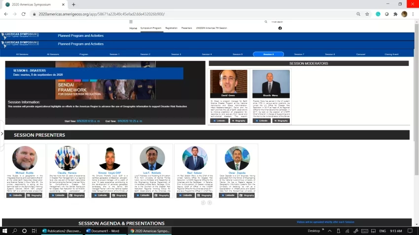
This session provided highlights on efforts in the Americas to advance the use of Geographic Information Systems (GIS) to support disaster risk reduction and work towards the goals of the Sendai Framework, a United Nations initiative to set clear targets and priorities for action to prevent new and reduce existing, disaster risks. David Green, program manager of NASA's Disasters Program and leader of the Committee on Earth Observing Satellites (CEOS) Disaster Working Group, was a session moderator in a dialogue about activities, challenges, and opportunities that Earth observations represent for regional disaster risk reduction organizations.
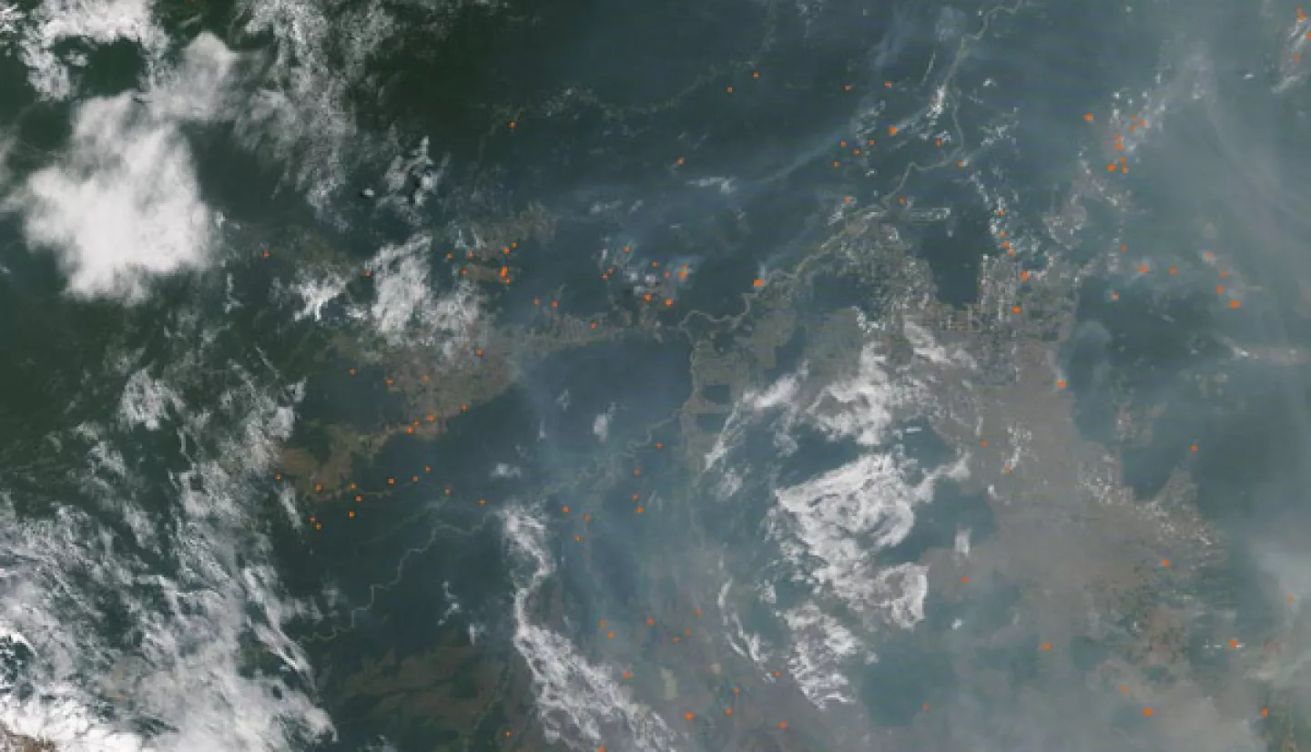
Bolivia Fires 2020
In Bolivia, an active 2019 fire season and shortage of rainfall during the 2020 wet season led to another extremely active fire season in 2020. According to media reports, more than half a million hectares of forest were burned in the Santa Cruz region as of September 19th, and Bolivia’s interim president Jeanine Áñez declared a national emergency due to the fires.
The NASA Earth Applied Sciences Disasters Program worked with regional stakeholders including representatives from the Bolivian Space Agency to provide access to Earth-observing resources to aid in risk management for the fires. Nighttime thermal infrared imagery from the Advanced Spaceborne Thermal Emission and Reflection Radiometer (ASTER) instrument on NASA’s Terra satellite was provided to aid in detecting fire hot spots. Another resource that was made available for tracking the fires was the Global Fire Emissions Database (GFED) Amazon Dashboard, which visualizes active fire detections from the Visible Infrared Imaging Radiometer Suite (VIIRS) instruments on the NASA/NOAA Suomi-NPP and NOAA-20 satellites. Fire emissions data for tracking air quality impacts were also made available through the Near Real-time Fire Emissions dashboard on the NASA Disasters Mapping Portal. Support was also being provided through the Global Wildfire Information System.
Nicaragua Volcano Supersite
The Geohazard Supersites and Natural Laboratory (GSNL), an initiative within the Group on Earth Observation (GEO) is a voluntary international partnership that aims to improve geophysical scientific research and geohazard assessment, promoting rapid and effective uptake of scientific results for enhanced societal benefits in Disaster Risk Reduction. The incomplete knowledge of seismic and volcanic phenomena and the slow uptake of scientific results by decision-makers can worsen the impact of volcanic eruptions and earthquakes, especially in less developed countries. This lack of knowledge can be caused by a lack of observations, but can also be due to barriers in accessing existing data and reusable scientific results.
The NASA’s Disasters Program is working through the AmeriGEO Disasters Working group in collaboration with the Centro de Coordinacion para la Prevencion de los Desastres en America Central y Republia Dominicana (CEPREDENAC) and Nicaraguan Institute for Territorial Studies (INETER). They have supported the development of a proposal for the creation of a volcano research supersite in Nicaragua. The supersite will research the volcanoes Cosiguina, San Cristobal, Telica, Cerro Negro, Momotombo, Peninsula de Chiltepe, Masaya and Concepción.
By establishing a supersite, the local scientific community will be able to increase their collaboration with the international community and focus their attention on important scientific questions. The advancements generated by these investigations will be transferred to end-users and decision-makers by the Supersite Coordinator, ensuring a smooth and rapid uptake of information.
University Forum of the Americas and the Caribbean
The NASA Disasters Program, working through the AmeriGEO Disaster Working Group, participated in the University Forum of the Americas and the Caribbean. This year's theme was “COVID 19, a Systemic Threat, Impacts, and Challenges.” The forum was organized in collaboration with the University Network of the Americas and the Caribbean for Disaster Risk Reduction (REDULAC/RRD). The event was held under the auspices of the U.S. Office of Disaster Assistance Abroad (USAID/OFDA) with the support of the Central American University Higher Council (CSUCA) and the United Nations Office for Disaster Risk Reduction (UNISDR). The forum was attended virtually by 8,500 people, showing great participation by the community of the Americas.
Paraguayan Space Conference Forum for Disaster Risk Reduction
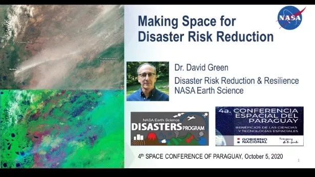
NASA representatives recently participated in the 4th Annual Paraguayan Space Conference, which took place from October 4th – 10th, 2020.
During the conference David Green, program manager for the NASA Earth Applied Sciences Disasters Program presented the keynote talk for the Forum on Disaster Risk Reduction entitled “Space for Disaster Risk Reduction,” which can be viewed here. In the talk, he explored how disaster risk can be managed from an earth systems perspective, and why situational awareness is needed to inform plans, support decision-making, and guide proactive intervention. Powerpoint slides from David’s talk can be downloaded here in both English and Spanish.
The Forum on Disaster Risk Reduction is part of an active collaboration between NASA and the Paraguayan government to enable the exchange of science and technology, and to promote access to Earth observations that can inform choice, support decision-making, and guide actions that can prevent disasters, reduce risk and strengthen resilience. Through leveraging these partnerships in the Americas, NASA aims to strengthen local communities and enable effective response throughout the disaster lifecycle.
NASA also participated elsewhere throughout the conference, with Deputy Director of NASA’s Earth Science Division Sandra Cauffman giving the keynote talk for the Forum on Earth Observation Applications, which can be viewed here.
Further talks from the conference can be viewed on the Paraguayan Space Agency YouTube Channel.
US, Mexico, Canada CEC Wildfire Workshop
NASA's Disasters Program recently participated in workshops hosted by the Commission of Environmental Cooperation (CEC) to strengthen early warning systems for floods and wildfires using Earth observations, data, models, and expertise, working collaboratively between Mexico, Canada, and the United States. The workshops are part of activities for the development of the Sendai Framework. In the context of the environmental, economic, and social linkages between Canada, Mexico and the United States, CEC facilitates effective cooperation and public participation to conserve, protect and enhance the North American environment in support of sustainable development for the benefit of present and future generations. Jean-Paul Vernier, a Disasters program coordinator from NASA's Langley Research Center, presented products made by the Disasters Program to support decision-making on the impacts of wildfires in the United States and Australia during 2020.
In addition, Margaret Glasscoe, a Disasters program coordinator from NASA's Jet Propulsion Laboratory (JPL), gave a presentation on her research project “Advancing Access to Global Flood Modeling and Alerting.” The participation of the NASA Disasters Program in the CEC Wildfire Workshop contributes to the implementation of the Sendai Framework Priority 1 - to understand risk in all its dimensions.


