In response to Tropical Storm/Hurricane Isaias, the NASA Earth Applied Sciences Disasters program area created maps showing areas of likely flooding and damage from the July 2020 storm in The Bahamas and Dominican Republic.
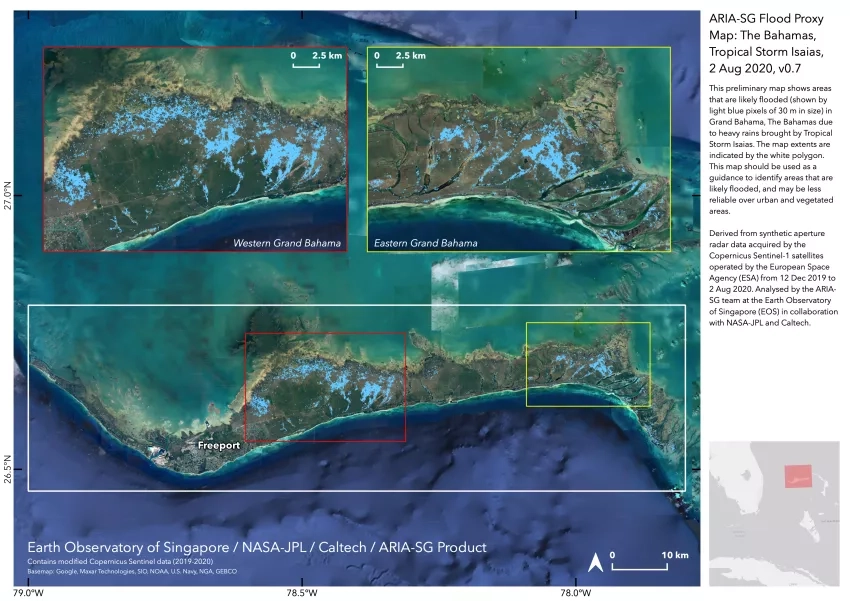
This Flood Proxy Map (FPM) shows areas that are likely flooded (shown by light blue pixels of 30 m in size) in Grand Bahama, The Bahamas due to heavy rains brought by Tropical Storm Isaias. This map should be used as a guidance to identify areas that are likely flooded, and may be less reliable over urban and vegetated areas. Derived from synthetic aperture radar data acquired by the Copernicus Sentinel-1 satellites operated by the European Space Agency (ESA) from 12 Dec 2019 to 2 Aug 2020. Analysed by the ARIA-SG team at the Earth Observatory of Singapore (EOS) in collaboration with NASA-JPL and Caltech.
The U.S. Southern Command and Caribbean Disasters Emergency Management Agency requested and received these detailed assessment maps following the heavy rains that occurred during the storm.
These maps are based on synthetic aperture radar (SAR) data from the Copernicus Sentinel-1 satellites, which are operated by the European Space Agency. The Advanced Rapid Imaging and Analysis (ARIA) team at NASA's Jet Propulsion Laboratory and the California Institute of Technology in Pasadena, California processed the data in collaboration with the Earth Observatory of Singapore.
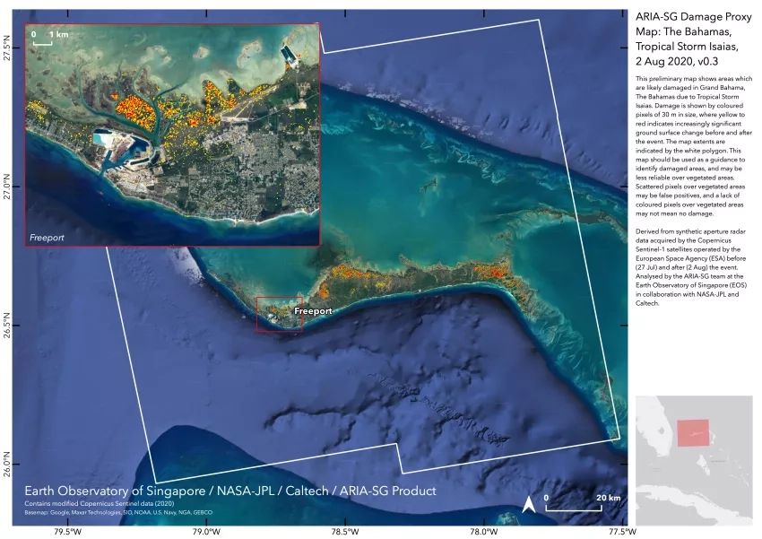
This Damage Proxy Map (DPM) shows areas which are likely damaged in Grand Bahama, The Bahamas due to Tropical Storm Isaias. Damage is shown by colored pixels where yellow to red indicates increasingly significant ground surface change before and after the event. This map should be used as a guidance to identify damaged areas, and may be less reliable over vegetated areas. Scattered pixels over vegetated areas may be false positives, and a lack of colored pixels over vegetated areas may not mean no damage. Derived from synthetic aperture radar data acquired by the Copernicus Sentinel-1 satellites operated by the European Space Agency (ESA) before (27 Jul) and after (2 Aug) the event. Analysed by the ARIA-SG team at the Earth Observatory of Singapore (EOS) in collaboration with NASA-JPL and Caltech.
Radar imaging relies on emitting a signal toward a surface and then recording the amount of signal that bounces back and its time delay. SAR uses an electromagnetic signal that travels at the speed of light and produces fine-resolution images.
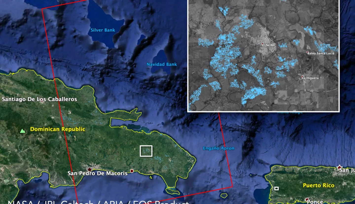
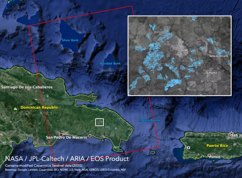
This Flood Proxy Map (FPM) shows areas that are likely flooded in blue across the Dominican Republic. The map was derived from synthetic aperture radar (SAR) data acquired on July 31, 2020 by the Copernicus Sentinel-1 satellites operated by the European Space Agency (ESA). Credits: NASA-JPL/Caltech ARIA Team.
The Disasters program area develops damage and flood risk mapping through the following NASA-funded program ROSES projects:
A.37 Global Rapid Damage Mapping System with Spaceborne Synthetic Aperture Radar (SAR) Data A.50 Group on Earth Observation (GEO) Work Programme Global Rapid Flood Mapping Project These maps can be interacted with and used for GIS applications on the Disasters Mapping Portal here.