Youn-Soo Kim, principal researcher at the Satellite Application Division of the Korea Aerospace Research Institute (KARI), recently completed a year-long sabbatical visit at NASA’s Goddard Space Flight Center, in which he collaborated closely with the NASA Earth Applied Sciences Disasters Program.
Kim is a member of the Satellite Application Division of the National Satellite Operation & Application Center at KARI. There, he helps manage satellite data generated by the KOMPSAT and Geo-KOMPSAT satellites and helps develop state-of-the-art technologies for widespread use of KARI satellite data. KARI is currently operating four low-Earth-orbit satellites called Arirang-2, -3, -3A and -5 (also known as KOMPSAT-2, -3, -3A and -5) and two geostationary satellites called Cheollian-1 and -2 (also called Geo-KOMPSAT-1 and -2). The Center is responsible for developing change detection and target indication algorithms and generating and distributing value-added products using KOMPSAT data. Upon returning to KARI, Kim aims to improve satellite data distribution and utilization of systems and to promote increased satellite data use in the public and private sectors.
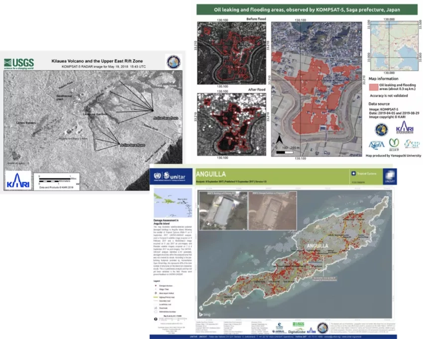
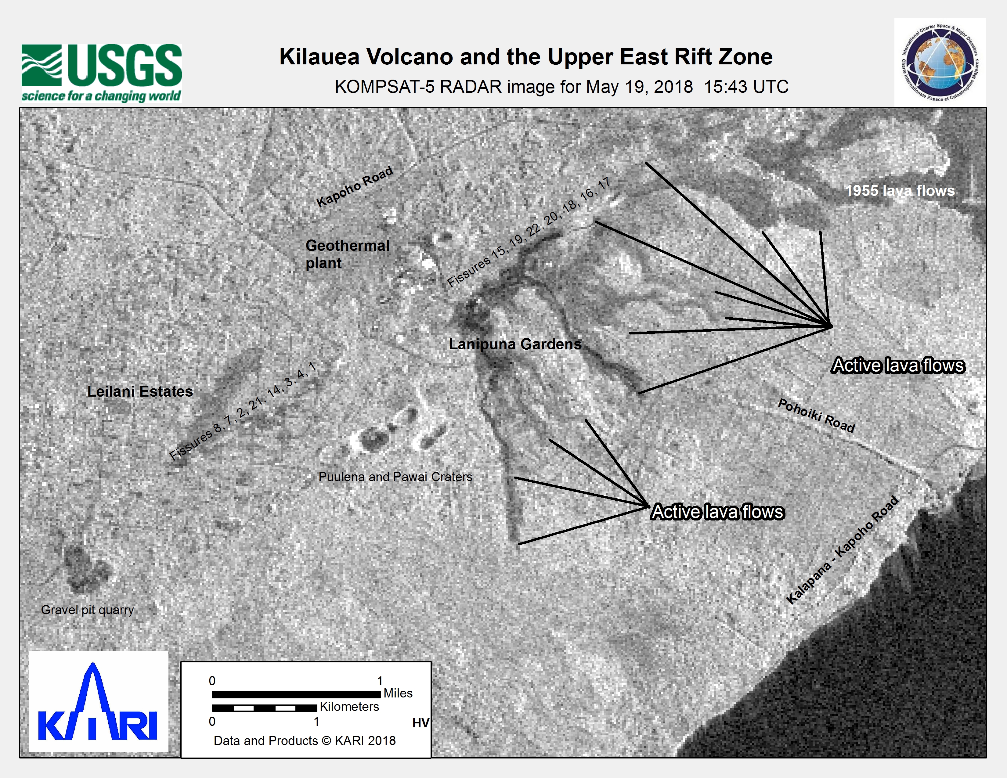
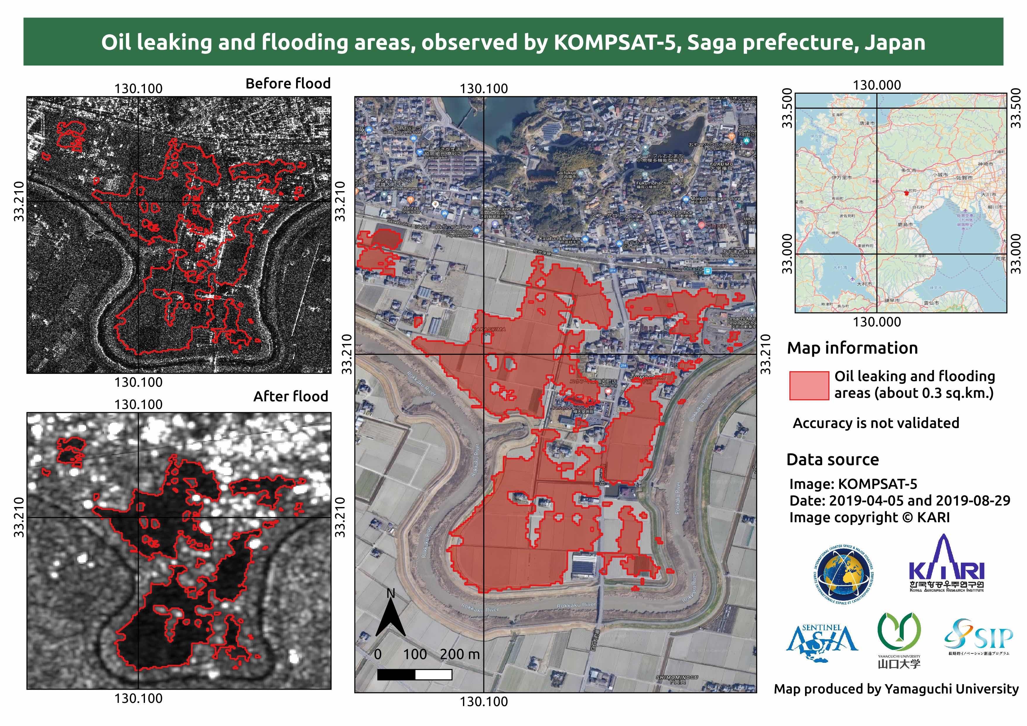
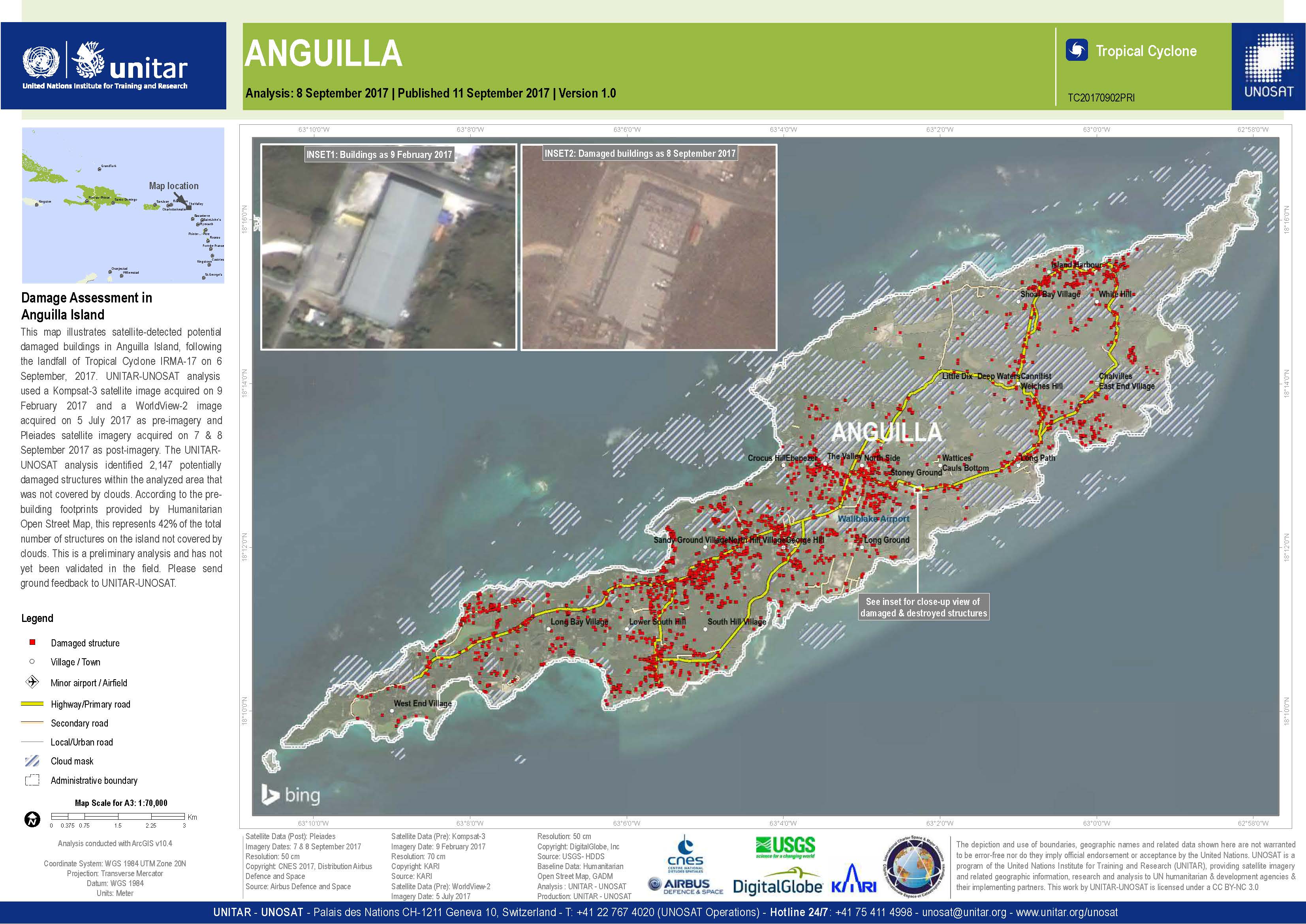
As a visiting scientist working with the Disasters Program, Kim strove to generate new collaboration opportunities with KARI. Both NASA and KARI have a strong emphasis on disaster preparation, emergency management, recovery, and resilience. Since its foundation in 1989, KARI has cooperated with foreign aerospace agencies and international organizations through cooperative agreements to expand the peaceful use of outer space. KARI has been an active member of the International Charter on Space and Major Disasters since 2011 and is providing satellite data collected by KOMPSAT-2, 3, 3A, and 5 to the charter. KOMPSAT data helped observe and analyze the damage from major disasters around the world, for which some examples are shown in the images below. These include mapping lava flow from the Kilauea volcano in Hawaii, mapping flood and oil leaks in Japan, and conducting damage assessment for Hurricane Irma.
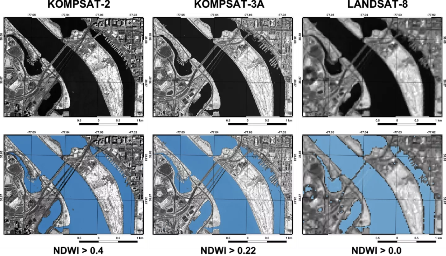
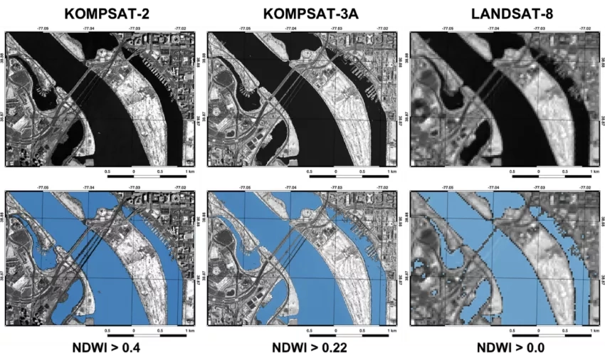
During Kim’s time at NASA's Goddard Space Flight Center, he worked with a team of researchers to analyze KOMPSAT data from a disaster response perspective. Normalized difference water index (NDWI) maps were created using KOMPSAT-2 and 3A multispectral images from around the Potomac River in the Washington D.C. area to assess the utility of KOMPSAT data for flood response. NDWI is a normalized band difference that highlights the presence of surface water. The river is clearly detected from the NDWI maps and compared well with observations from NASA’s Landsat-8, as shown in the below image. Positive values in NDWI indicate the presence of water, but due to different instrument characteristics, water/non-water classification thresholds were selected by an adaptive statistical approach. The coverages generated by KOMPSAT and Landsat-8 both agree well despite their differing instrument resolutions. The spatial resolutions of KOMPSAT-2 and 3A multispectral images are 4m and 3.2m (1m and 0.8m panchromatic), respectively, resulting in higher resolution water masks compared to Landsat-8 with its 30 m resolution. The higher resolution of KOMPSAT-2 and 3A instruments makes them more suitable for flood mapping, especially in urban areas, because they can sample inundated roads and bridges without spectral mixing from adjacent buildings.
In addition to multispectral KOMPSAT images, the team also analyzed KOMPSAT-5 Synthetic Aperture Radar (SAR) images. Imagery was provided to the NASA Disasters Program to aid their effort supporting the 2020 Norilsk oil spill in Russia. The high resolution X-band KOMPSAT-5 imagery had a higher chance of detecting oil compared to lower resolution SAR imagery collected by other instruments, but in this case, no oil was detected – likely due to the leak being stopped before the acquisitions took place. Nevertheless, the exercise allowed testing of coordination protocols between NASA and KARI and was a worthwhile endeavor that helped bring the two space agencies working closer during an emergency.
Thanks to Kim and the contacts he made within the NASA Disasters Program during his visit, NASA and KARI will continue to expand their collaboration efforts. Future activities will focus on joint disaster research, with the goal of increasing coordination with international organizations such as the International Coordination for Spaceborne SAR, the CEOS Disasters Working Group, and the Group on Earth Observations (GEO). These efforts aim to improve science algorithms for both agencies and potentially shorten the latency of acquiring disasters-related data by having access to an increased number of satellites.


