Projections of climate change from climate models are a fundamental basis for climate resilience planning across many elements of society and ecosystems around the world. Climate projections sets are created when experts select and further process climate model outputs in order to create information in support of mitigation, adaptation, and risk management actions. Scientists can use a variety of climate projection datasets with a range of distinguishing factors that may be matched to the unique needs of different application types .
What is a Climate Projection?
“Climate projections are simulations of Earth's climate in future decades based on assumed 'scenarios' for the concentrations of greenhouse gases, aerosols, and other atmospheric constituents that affect the planet's radiative balance.” (Copernicus/EU). Projection sets are often a curated group of projections intended to better resonate with observed climate while capturing key uncertainties, scenarios and storylines for future conditions.
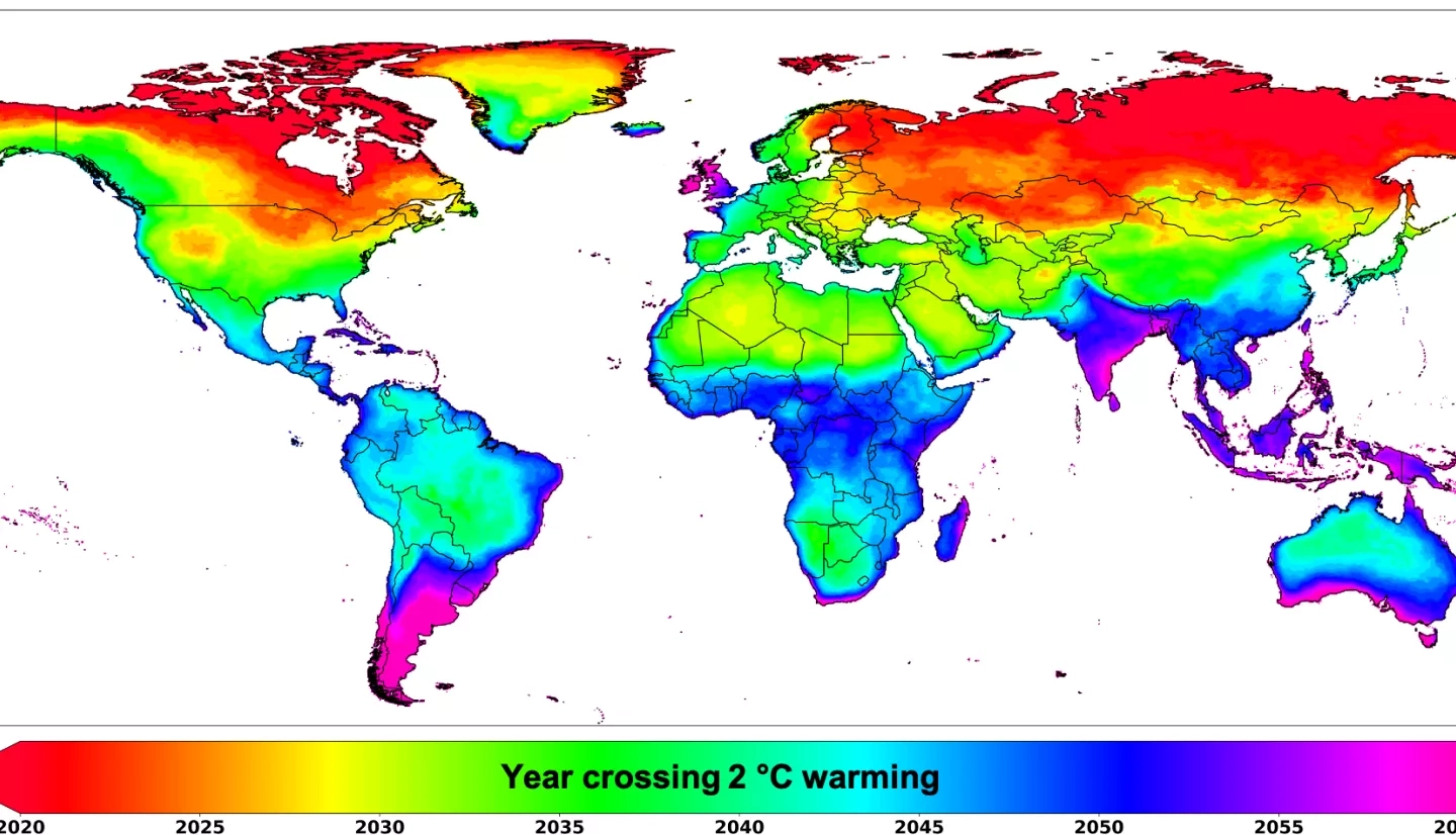
Climate projections are driven by fundamental physical processes throughout the climate system as driven by natural variability (e.g., volcanos, solar cycles, orbital dynamics) and human influences (greenhouse gas and aerosol emissions, land cover and land use change). Projections can follow scenario pathways (e.g., representing larger trends in societal development, population growth and technological change) or storylines of physical events or societal decisions. This information all goes into a climate model which is used to project what the climate will look like in the future. Most of these projections focus on the 21st century (out to 2100) given our focus on the consequences of near-term climate action even as the choices we make today are likely to affect climate for centuries to come.
Climate projections allow us to anticipate hazards and risk to natural and human systems over time, providing a picture of what mitigation or adaptation efforts need to be prioritized for implementation. Information from Earth observing satellites and physical models of each aspect of the climate system are critical for the simulation of future climate conditions as well as various approaches to downscale and bias-adjust projections for more robust estimation of future impacts.

Climate projection sets are particularly useful when they match the needs and scales of specific decision processes for climate adaptation, mitigation, and risk assessment.
Adaptation includes efforts to better adjust ourselves to the current or projected climate. This can include our homes, infrastructure, habits, food, water and energy systems and many other facets of our interaction with the environment. Climate adaptation efforts reduce vulnerability and exposure to climate hazards, for example by working to build flood defenses, providing cooling centers for heat waves, installing better-draining pavements to deal with floods and stormwater, and improving water storage and use in anticipation of more arid conditions. Adaptation efforts may also target potential opportunities to benefit from climate changes, for example adjusting agricultural seasons to take advantage of longer growing seasons in some regions.
Mitigation efforts seek to reduce the overall human influences that are warming the climate system. Examples of this include increasing home energy efficiency, streamlining transportation routes, painting roofs white, and reducing acute urban heating through misters and trees planted in neighborhoods with few green areas.
Risk management applications seek strategies to deal with adverse impacts on nature and society beyond our ability to mitigate and adapt. This might include efforts to steer disaster relief aid to regions hit by tropical cyclones or to develop insurance schemes for agricultural regions facing heightened levels of drought.
With all that being said, you may be wondering where you can learn what data are available and how to use climate projection sets in your own adaptation, mitigation, or risk management efforts.
On September 19th and 20th, NASA’s Applied Remote Sensing Training (ARSET) Program offered a two-part, online, introductory-level training on Selecting Climate Projection Sets for Mitigation, Adaptation, and Risk Management Applications. This training, offered in collaboration with the Goddard Institute for Space Studies (GISS), is open to the public and is designed to help you discern what climate projections to choose depending on your specific needs and applications. It provides an overview of resources for choosing climate projection sets, defines a list of distinguishing characteristics of climate projection sets, and then highlights the main benefits and drawbacks of different features of projection sets.
To see the recordings for this training and access the materials, visit: