
On One Health Day, and every day, NASA Earth is committed to collaborative projects that apply Earth science satellite imagery and data to encourage community engagement in environmental and public health issues. The international campaign, celebrated annually on November 3rd, gives us special reason to celebrate our commitment to the One Health concept and rally support for this type of critical problem-solving. By encouraging public engagement from a wide range of disciplines, we support the One Health Day campaign in promoting the development of transdisciplinary projects that address health threats to humans, animals, and the environment.
Here are a few recent examples of public health projects from NASA Earth’s Applied Sciences Program that highlight how we are Making Space for Earth.
Preventing Heat-Related Illnesses in New York
Heat-related illnesses and deaths result from the body’s inability to cool itself during extreme temperatures. Scientists used the NASA-sponsored North American Land Data Assimilation System (NLDAS) to examine fine-scale temperature data and compared it to health outcomes across New York State. These data showed that adverse health effects actually occurred at lower temperatures than initially thought, which prompted officials to reduce the Heat Advisory threshold in 2018 from 100⁰F to 95⁰F, in an effort to better alert the public of the potential of heat-related illness.
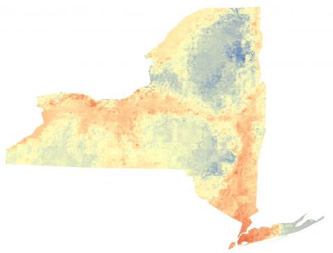
Neil Stuart, lead meteorologist for the National Weather Service Forecast Office in Albany, New York, said, “The criteria for heat-related advisories had been in place for over 20 years and was based on coordinating with partners regarding frequency of heat events. Now we will be issuing heat-related advisories based on science-based temperature, health, and hospital-visit data.” By taking appropriate precautions, the public can reduce the adverse effects of extreme heat on themselves and their pets.
Cholera Forecasts Enhancing National Preparedness and Support Measures
Cholera is a potentially deadly diarrheal disease that results from ingesting food or water contaminated with the bacterium Vibrio cholerae. In 2017, a NASA-supported project used Earth-observing data from the Global Precipitation Measurement (GPM) mission and Moderate Resolution Imaging Spectroradiometer (MODIS) instruments to understand the environmental factors that lead to cholera outbreaks. With these data, the project scientists developed a forecast model, which predicted areas at high risk for V. cholerae across Yemen.
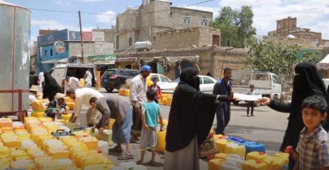
In 2018, the British government and international aid groups in Yemen began using these new cholera forecasts to target their work in reducing cholera risk. In the same way meteorologists issue severe storm warnings, these risk maps and forecasts would allow people to prepare for and prevent outbreaks, and they promise to be an important tool for public health preparedness.
“This ground-breaking initiative is a testament to the importance of interdisciplinary and multi-agency efforts to improve disease preparedness and response,” said John Haynes, program manager for Health and Air Quality Applications in NASA’s Earth Science Division. By understanding the source and transmission mode of this environmental pathogen, we can promote the use of proper hygiene and sanitation practices to reduce risk of human or animal ingestion of contaminated food or water.
Space Views Aid Florida ‘Red Tide’ Health Alerts
Large accumulations of the dinoflagellate Karenia brevis in the coastal waters can cause “red tides” that are toxic to humans and marine life. NASA Aqua and Terra satellite data—together with the HABscope smartphone app for video uploads by trained citizen scientists—helped detect, forecast, and target responses to these harmful algal blooms on the Florida Gulf Coast. This information can facilitate risk assessment and decision making to understand these environmental disturbances and safeguard human and animal health.
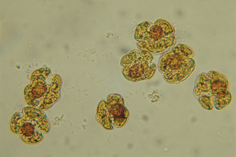
Richard Stumpf, an oceanographer with the National Oceanic and Atmospheric Administration, said, “Respiratory distress forecasts can now be produced 1-to-2 times per day for specific beaches along the Florida Gulf Coast. The combination of Earth observations with rapid field monitoring will increase the accuracy and usefulness of the forecasts.” By being aware of harmful algal bloom forecasts, humans can take precautions and avoid unnecessary activities with their family and pets near the affected coastal waters and shoreline.
Learn more about how NASA Earth’s Health and Air Quality Applications Program supports One Health Day by using Earth-observing data in air quality management and public health.


