Oct. 13 is the 2021 International Day for Disaster Risk Reduction (DRR) – a day that asks governments, organizations, and individuals alike to recognize the progress made toward reducing global disaster risk. Every year, the United Nations Office for Disaster Risk Reduction (UNDRR) picks an important theme to focus their efforts toward, and this year’s theme is “international cooperation for developing countries to reduce their disaster risk and disaster losses.”
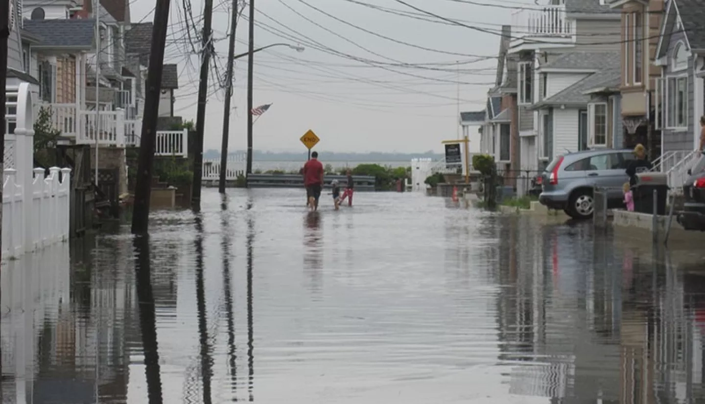
Disasters occur at the intersection of natural hazards and communities – making them the consequence of societal decisions. Where and how we build, the resources we devote to mitigation and response, and the actions we take regarding exposure and vulnerability can all affect a disaster’s severity. However, decision makers need reliable data to make informed societal decisions. NASA’s Earth Applied Sciences Disasters program area uses Earth-observing satellites to provide decision makers worldwide with a space-based perspective on disaster risk, guiding actions that increase overall disaster resilience.
This year, NASA recognizes the nations that need disaster support the most – developing nations. When disasters strike, developing nations experience higher rates of lives lost and infrastructure damaged than developed nations do. As a result, communities in developing countries are pushed further into poverty with each disaster, creating an endless cycle of economic distress. To combat this cycle, the Disasters program actively seeks out collaborations with local emergency organizations and governments in developing nations to share life-saving resources and information, helping communities recover from disasters and become more resilient to future events.
Here are just a few examples of NASA’s recent collaborations with developing nations:
Forum on Disaster Resilience in Southern Africa
In Southern Africa, communities are hit with severe storms, flooding, droughts, wildfires, and biological hazards every year, creating the need for reliable hazard information. To address this need, the United Nations’ Space-based Information for Disaster Risk Management and Emergency Response (UN-SPIDER) teamed up with the Center for Remote Sensing of Land Surfaces of the University of Bonn (ZFL) to organize a regional forum July 13 - 15, 2021, on the use of space-based technologies and information for disaster risk management in Southern Africa.
During the three-day forum, two teams from the NASA Disasters program presented their work on disaster risk assessment within Southern Africa. Bringing NASA capabilities to regions outside of the United States requires working with international partners, making collaboration essential to NASA’s mission. Sharing Earth observation data with agencies in Southern Africa and the United Nations pushes NASA one step closer to its goal, while enabling disaster management, risk reduction, and resilience in Southern African communities.
The Next Generation of Galapagos Conservationists
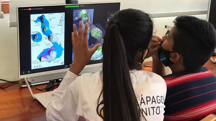
Galápagos Infinito, or Infinite Galápagos in English, is an educational program that seeks to promote an in-depth understanding of the archipelago’s environment and island culture among its 11-12-year-old inhabitants. Ricardo Quiroga, an AmeriGEO and NASA Disasters Program coordinator, gave a presentation on the NASA Disasters Program to the students on Jan. 12 to introduce them to NASA’s Earth data.
More than 500 Galápagos Infinito students had the opportunity to explore data on ocean and island temperatures from the NASA Disasters Mapping Portal, an online mapping platform that displays near real-time products and disaster information. This exercise allowed the students to visualize and assess climate change impacts on their archipelago’s ecosystem. The students were also able to use these NASA tools for an educational mission involving environmental risk assessment and investigating solutions for mitigating climate change.
Quiroga says “Providing these young Galapagos Island students with this data, and the tools to understand it, gives them a deeper understanding of their territories and the natural phenomena affects them, while inspiring those students to protect their local environment.” Galápagos Infinito hopes that this experience will expand the students’ perspectives on all the different ways that scientists can study the Galápagos’ environment, whether that research is conducted on the ground, from a boat, or even in space.
La Soufrière Eruption 2021
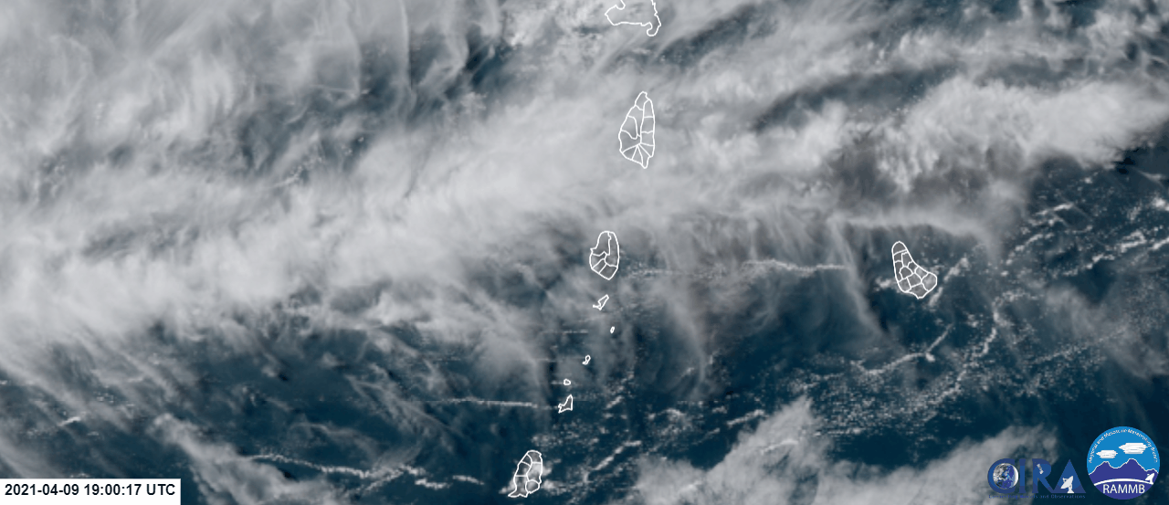
In early April, the La Soufrière volcano on the island of Saint Vincent violently erupted - the first major eruption since 1979. In addition to sending volcanic ash and gas high into the atmosphere, the explosive eruptions blanketed much of the island in volcanic ash and rock, and triggered pyroclastic flows - dangerous and fast-moving avalanches of hot ash, gas and debris.
Researchers from the NASA Disasters program area, who had been monitoring the volcanic activity on Saint Vincent since January, used satellite data to observe impacts to the island and local communities that the eruptions unleashed. Using these data, the researchers identified areas where the volcanic ash and pyroclastic flows may have impacted local population centers. They also used the data to track potential damage to vegetation.
By using satellite data to observe the island before and after the eruption, researchers can get a more comprehensive view of how the eruption impacted local communities compared to ground-based observations. These data are critical to arming local governments and disaster response agencies with the tools they need to make informed decisions for response and recovery efforts.


