The August Complex fire formed under very hot and dry conditions in northern California on August 17th, 2020. Reportedly, 37 individual fires initiated by lightning strikes merged to create this conflagration, which claimed the life of one firefighter on August 31st, 2020 according to the U.S. Forest Service. Researchers from the MISR Active Aerosol Plume-Height (AAP) Project, based out of NASA Goddard Space Flight Center and the University of Maryland, along with colleagues from JPL and the NASA Langley Research Center used data from multiple Earth observing satellites to map the properties and dispersion of smoke plumes from the August Complex fires on August 31st.
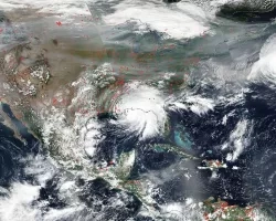
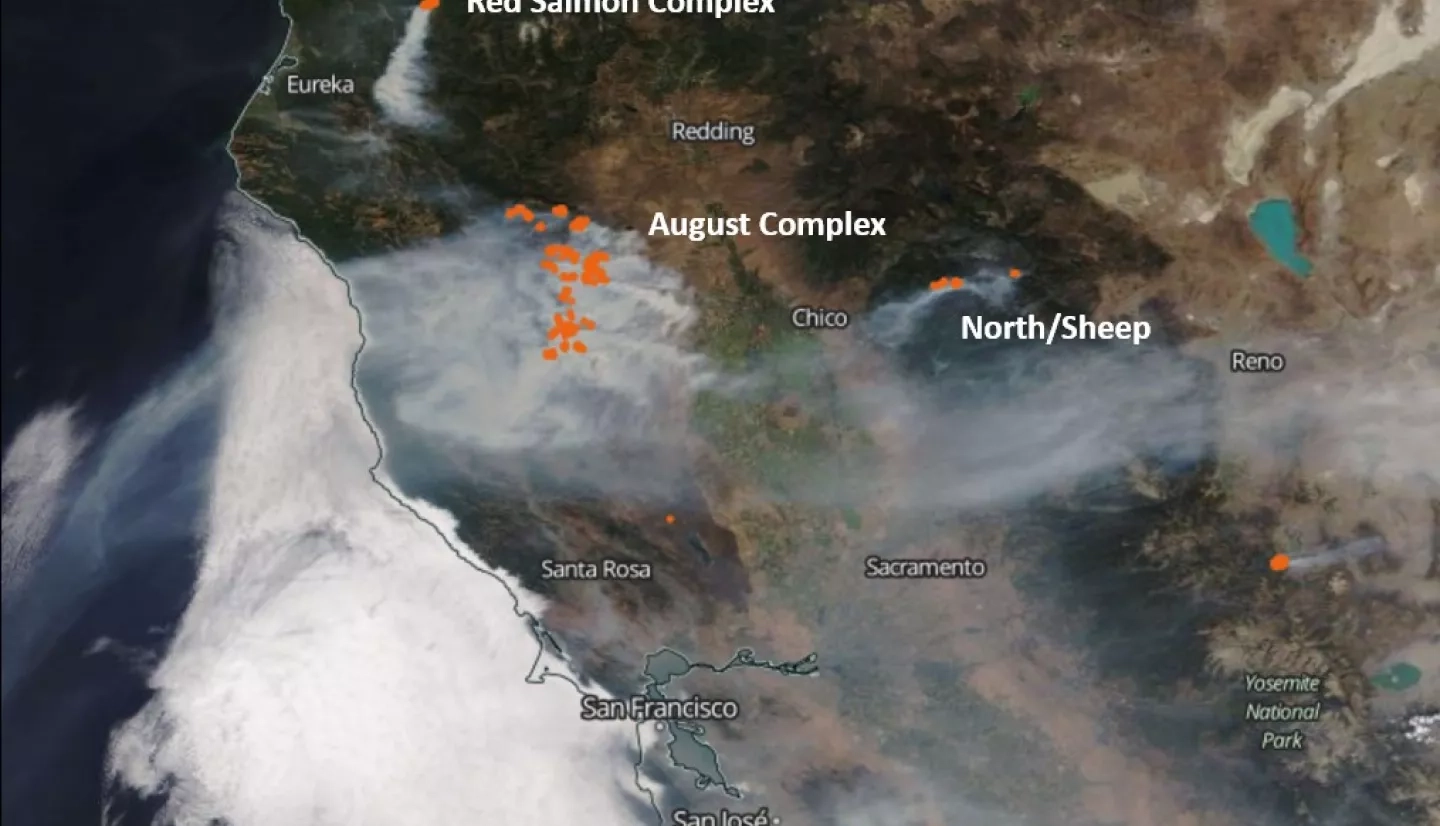
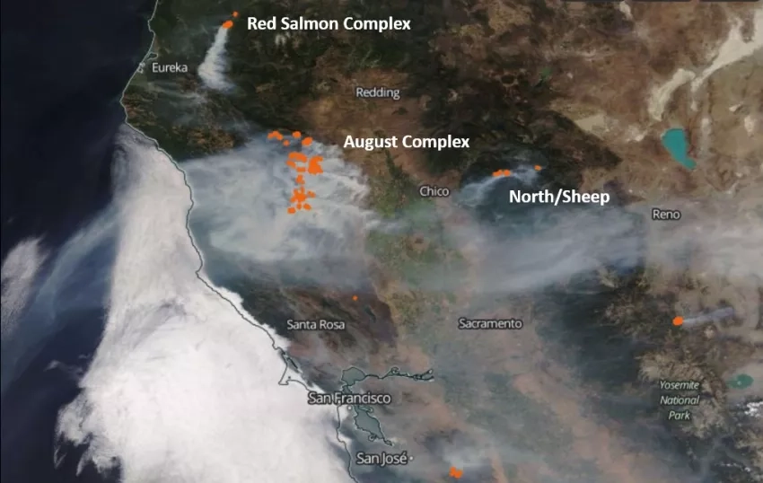
The true-color image below was acquired by the Moderate Resolution Imaging Spectroradiometer (MODIS) instrument aboard NASA’s Terra satellite at about 12:15pm local time on that day. Fire hot-spots, identified at 4 microns wavelength, are highlighted as red dots and superposed on the image. By September 2nd the fire had consumed over 240,000 acres and was about 20% contained.
The Multi-Angle Imaging Spectro-radiometer (MISR) instrument aboard NASA’s Terra satellite obtains less coverage than MODIS. However, MISR stereo imagery makes it possible to map injection heights and associated wind vectors for wildfire smoke and volcanic eruption plumes. With these data researchers can also retrieve smoke particle properties, track their evolution downwind, and distinguish them from meteorological clouds.

On August 31st MISR imaged multiple smoke plumes from the August Complex fire dispersing eastward from the Mendocino National Forest in northern California. Although MISR observed the scene at ~12:15pm local daylight time, parts of the plume had already reached ~4 km elevation, which is likely above the near-surface planetary boundary layer (PBL). This matters when predicting air quality; above the PBL, smoke tends to stay aloft longer and travel farther. Fires tend to intensify further later in the day. At plume elevation winds were up to 8 m/s, based on the MISR retrievals.
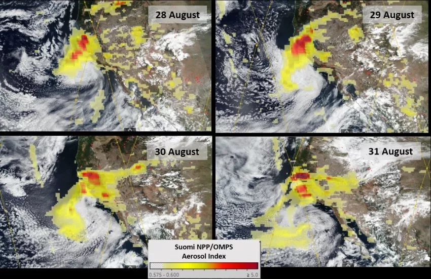
The Ozone Mapping Profiler Suite (OMPS) aboard the NASA/NOAA Suomi NPP satellite acquires daily global coverage at ~50 km pixel resolution in ultraviolet channels. A qualitative Aerosol Index (AI) indicating the amount of airborne particles is retrieved from these measurements. The four-day time series above shows smoke from the August Complex fire being transported generally toward the west and circulating counter-clockwise. The results are superimposed on true-color imagery from the Visible Infrared Imaging Radiometer Suite (VIIRS) instrument on the same satellite.
Whereas MISR maps the elevation of thicker, near-source plumes, the CALIOP lidar instrument aboard NASA’s CALIPSO satellite captures data in narrow (~100 m) vertical slices or “curtains” through the plume, and is very sensitive to even thin smoke plumes far downwind, both night and day. In addition to backscatter profiles, CALIPSO can distinguish broad classes of cloud and aerosol features from observations at two wavelengths, one that includes polarization sensitivity.
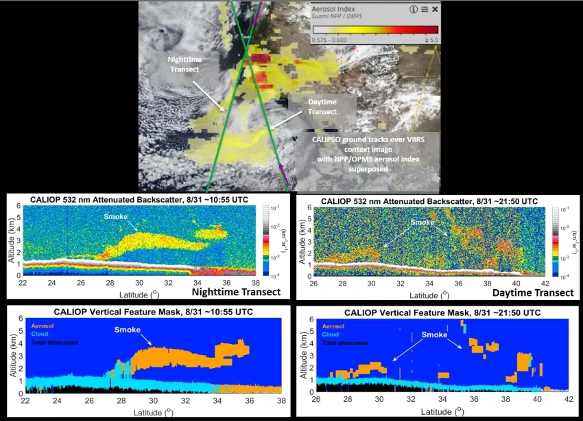
On August 31st CALIPSO captured older smoke from west of the August Complex fires in two overpasses that transected with the OMPS observations, which are shown in the images above. Smoke in the earlier nighttime overpass resides above a shallow cloud deck 3-4 days downwind. It descends from ~4 km to ~1.5 km after crossing the California coast into the shallow, stable atmospheric boundary layer over ocean. Smoke observed by CALIPSO 11 hours later is scattered at elevations ranging from ~1.5 to ~6 km; it is younger at 36-40°N and older farther south.
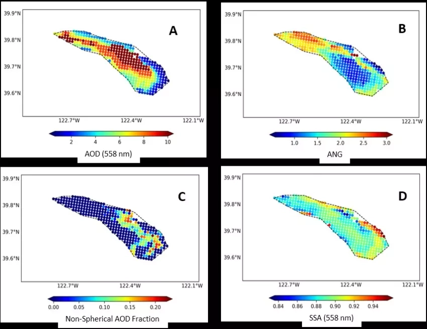
Shown in the image above, the MISR Research Aerosol (RA) retrieval algorithm produced: (A) aerosol total-column amount (optical depth – AOD), (B) an aerosol size constraint (Angstrom Exponent (ANG), which decreases for increased effective particle size), (C) AOD fraction of non-spherical particles, and (D) particle light-absorption (SSA, equal to 1 for non-absorbing particles, and <1 for darker particles).
For this southerly portion of the August Complex fire smoke plume, AOD exceeds 8; the particles are emitted small (ANG >2) and dark (SSA <0.86), typical of black carbon that is associated with intense burning. AOD remains high in the plume core, and actually increases downwind as the particles become larger (ANG ~1) and somewhat brighter (SSA ≥0.91). It is possible that volatile organics and/or water are condensing on the particles as the plume cools downwind. MISR also observed a modest fraction of non-spherical particles (~10-15%) that might be soil particles mobilized by the fire. However, from a single satellite snapshot, researchers cannot rule out changes in emissions at the source as accounting for some of the observed downwind differences.
Coordinators and researchers from the NASA Earth Applied Sciences Disasters Program are hard at work developing maps, imagery and analysis such as these to aid local agencies and response teams in understanding the impacts from the western U.S. fires and the potential risks to people, infrastructure, and the environment. The Program is working closely with stakeholders from the California State Guard, the Federal Emergency Management Agency (FEMA), and many others. Learn more about these efforts.