Researchers from the NASA Earth Applied Sciences Disasters Program are using data from multiple satellites to study the formation of fire-induced clouds from the Australian bushfires, known as pyrocumulus clouds, and their potential impacts to Earth’s atmosphere and climate.
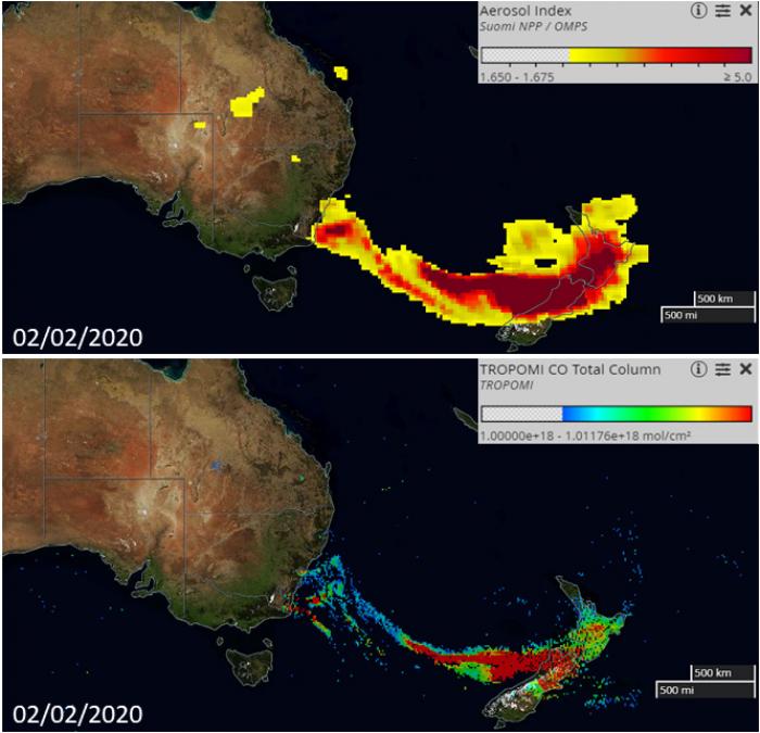
On February 2nd, 2020 the Ozone Monitoring Profiler Suite (OMPS) onboard the NASA-NOAA Suomi National Polar Orbiting Partnership (Suomi NPP) satellite observed a 3000 km-long smoke plume extending from the Australian East Coast to New Zealand across the Tasman Sea. The visualizations above show the so called "Aerosol Index" from OMPS (top image), which indicates the presence of aerosols such as soot, and would be seen as black and brown clouds through human eyes. These aerosols absorb solar radiation, which contributes to the warming of the atmosphere and has potential long-term implications for Earth’s climate.
On the same day the TROPOspheric Monitoring Instrument (TROPOMI) spectral imager onboard the European Space Agency (ESA) Sentinel 5 Precursor satellite captured the presence of carbon monoxide (lower image), a colorless and odorless gas formed by incomplete combustion, which was also emitted by the fires at the end of January. Using multiple satellite measurements of aerosols and gas from the same time period gives a more complete picture of the smoke plume from those fires and where the smoke is being transported. The NASA Disasters program then analyzed data from additional satellites to understand the origin of the smoke and its potential impacts.
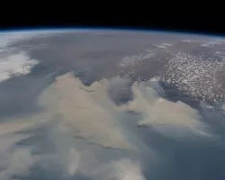
Three days prior to the OMPS and TROPOMI overpasses, the Japan Meteorological Agency (JMA) Himawari-8 satellite captured the data shown in the above animation. The animation was produced using NOAA’s Cooperative Institute for Research in the Atmosphere (CIRA) GeoColor product, which combines red, green, and blue imagery to produce a realistic depiction of the data as if it were seen from space by the human eye. Smoke has a brownish or grayish color, while clouds have a white color. Smoke can also be distinguished as having a wispy texture, whereas cumulus clouds have a bumpy texture.
This data shows smoke from the bushfires along Australia’s southeast coast on January 30, 2020 during a 6-hour period from 2:10 - 8:00 UTC and illustrates the unique phenomena of pryocumulus clouds forming from the fires. Pryocumulus clouds, abbreviated as “PyroCu” and also referred to as “flammagenitus” clouds, are formed when intense heat from fires causes air to rise rapidly into the atmosphere – a process known as pyro-convection. Pyrocumulus clouds can be seen developing around 5:00 UTC.
In this animation the strongest updrafts can be seen directly above the fires, and the smoke turrets produced by those updrafts cast shadows on the surrounding clouds and smoke indicating that they are higher. The clouds reach high enough to reveal vertical wind shear in the atmosphere, with air at lower altitudes moving on-shore and air at higher altitudes moving off-shore. The smoke reached 5-6 km into the atmosphere and was then transported across the Tasman Sea to New Zealand, which is also reflected in the OMPS and TROMOMI data. Australian bushfires have led to significant amounts of smoke landing on glaciers in New Zealand, which affects the albedo (reflective properties) of the snow and can lead to increased melting of the snow and glaciers.
The development of pyro-convection by fires has important local implications for firefighting response efforts, but also has long-term atmospheric impacts. Pyro-convection can produce gusty winds at the surface known as outflow boundaries, which can cause quick and erratic changes in the fires behavior. These outflow boundaries were a factor in the 2013 Yarnell Hill fire in Arizona that claimed the lives of 19 “Granite Mountain Hotshot” firefighters (source) . Pyro-convection also transports smoke higher up into the atmosphere, which has potential long-range implications Earth’s atmosphere and climate. Satellite data reveals that some of the smoke emitted from the Australian bushfires at the end of December 2019 have now reached almost 30 km into the atmosphere, with as-of-yet unknown consequences on Earth’s climate and ozone layer.