Seen from a space-based perch, Earth is resplendent in hues denoting a restless biosphere and thriving life. But look more closely, and trouble spots frequently appear: tumult across the face of a dazzling “Blue Marble” that include earthquakes, large-scale fires, volcanoes, floods, landslides, tropical cyclones, to name but some. To understand and help to manage and mitigate such dangers, society turns to one of the most successful remote-sensing initiatives in the NASA’s history.
In part supported by NASA’s Disasters Program, the system known as LANCE — short for Land, Atmosphere Near real-time Capability for EOS (Earth Observing System) — collates satellite data to deliver imagery of intense disturbances across the globe: usually less than three hours after initial observations. As it enters its second decade of operation, LANCE provides subscribers free and open access to more than 130 near real-time data products and imagery from 12 satellite instruments.
“Disasters have helped make users aware of how useful LANCE can be,” said Tian Yao, Disasters Program coordinator for LANCE. “It’s different from standard [approaches]. In those cases, data latency can be up to a few weeks. Having data in a few hours — near real-time — makes a big difference.”
Not just disasters-related intelligence is available. Information also can be gathered on severe weather, lightning strikes, snow cover, dust storms, flooding, the health of agricultural crops, and particles suspended in the atmosphere known as aerosols. LANCE data can be used to forecast and monitor invasive species, large-area insect infestations and disease-triggering pests; track the extent and robustness of forest cover; assess air-quality information to protect health; and even map the extent of oil spills in the ocean.
“A number of changes have to be made to the standard processing approach in order to generate products within 3 hours of observation time.” said LANCE Manager Karen Michael. “The required algorithm inputs are either relaxed (not as stringent) or expedited. Data from LANCE is available in various formats, and imagery can be visually explored in NASA Worldview.”
The EOS Data and Operations System (EDOS) is the primary provider of all LANCE instrument data directly downloaded from NASA EOS satellites like Terra, Aqua and Aura. In 2011, EDOS made significant enhancements to the way these data were streamed from ground stations, improving processing and prioritization, which helped reduce data latency.
Strong Societal Benefits
Today, LANCE provides a means to easily download near real-time imagery, interactively explore that imagery, and download the underlying digital data. The LANCE-powered Global Imagery Browse Services (GIBS) premiered in 2011 and the NASA Worldview interactive data visualization application debuted in 2012. GIBS and NASA Worldview were game-changers in the way near real-time imagery were distributed and used, allowing for quick and easy access to daily, global imagery without significant delay.
One of the most notable additions to the LANCE arsenal is the Fire Information for Resource Management System (FIRMS), initially developed at the University of Maryland. FIRMS was transitioned to LANCE in May 2010, becoming formally operational in May 2012. FIRMS provides near real-time thermal anomaly data (including an approximate location of a detected hotspot) from the Moderate Resolution Imaging Spectroradiometer (MODIS) and Visible Infrared Imaging Radiometer Suite (VIIRS) instruments.
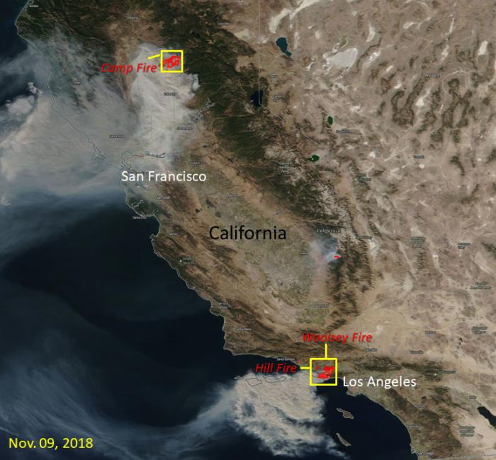
This November 2018 remote-sensing image shows the extent of the Camp Fire, Woolsey Fire and Hill Fire burning in California, where the red outlines with smoke indicate areas of active fire. The image was made possible the VIIRS instrument on board the Suomi National Polar-orbiting Partnership satellite platform, and in conjunction with the LANCE Near Real-Time Fires and Thermal Anomalies product and true-color imagery via NASA Worldview.
Global active fire detections can be viewed interactively using the FIRMS Fire Map application, and FIRMS users can sign up to receive email fire alerts notifying them of potential conflagrations detected in specific areas of interest. Through this free service, alerts can be received in near real-time, or as daily or weekly summaries. Every week approximately 240,000 FIRMS alerts (including daily alerts, rapid alerts, and weekly alerts) are sent to users in more than 160 countries, according to the FIRMS team.
“There are really amazing societal benefits in making these data widely available,” said Diane Davies, LANCE operations manager. “Imagery can show the extent of damage. Overlay it with GIS data, and you get a really good idea of the impacts. You can both respond and plan much more effectively.”
From Wartime to Peacetime
Born from post - 9/11 conflict, LANCE’s genesis was during Operation Enduring Freedom in 2001, as Allied forces pursued al-Qaeda and Taliban militants within Afghanistan. Unfamiliar with the terrain and the weather systems that cloaked operational areas, military planners looked to space for guidance.
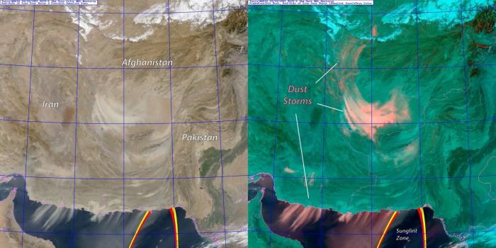
“[The military] was in a brand-new place and had virtually no experience with the environment and the weather,” said Jeff Hawkins, former head of the Satellite and Meteorology Application Section within the U.S. Naval Research Laboratory (NRL). “Frankly, we needed a handle on the dust storms that grounded all aircraft, both fixed-wing and rotary. It basically brought all operations to a halt and directly affected air support from carriers. We wanted to know: Where will the dust storms go? How strong will they be? How long will they last?”
MODIS instrumentation already in orbit would provide the solution. As a research-grade sensor the main issue for MODIS was its ~18 hour delay in data availability—a latency that rendered it nearly useless for operational support. The sense was that MODIS could potentially be a game changer to supporting the U.S. and Coalition response to 9/11 in Afghanistan, if only it could be accessed faster.
To address the challenge, a multi-agency and multi-disciplinary team was formed, involving both Department of Defense (DoD) and civilian agencies, including NOAA and NASA. The ‘Near Real-Time Processing Effort’ (NRTPE) was born. Through a new downlink strategy, involving an additional downlink station and a communications satellite network, these critical data became available in near real-time. By the summer of 2002, the NRTPE team had managed to reduce MODIS data latency to as little as two hours: a boon for rapid-response military sorties.
An NRL Monterey satellite applications group that included Steven Miller — now the Deputy Director of the Cooperative Institute for Research in the Atmosphere (CIRA) at Colorado State University — would leverage these new NRTPE-enabled MODIS to change the calculus of environmental awareness in the Afghanistan operations theater.
“The right people at the right levels of NOAA, NASA and the DoD talked to each other,” Miller said. “Everyone was working together hand-in-hand, in what we called a ‘badge-less environment.’ It was neat to be a part of it! We all had a common purpose.”
Miller’s science innovations led to development of a MODIS dust-detection product that screened out clouds and adjusted for complex topography, allowing for far better situational awareness, prediction and planning for carrier- and land-based air missions. The near real-time availability of this product was key to providing up-to-date information critical to mission success.
“This is one of those rare occurrences where the stars align,” Hawkins said. “You have a specific problem, a dedicated group, and terrific talent. We were able to generate a useable and reliable product. All the pieces fell into place to make a genuine success story.”
By 2008, a growing demand for more, better and quicker remote-sensing information would spur NASA to build upon and transition the wartime effort to peacetime purposes: a robust and widespread means of processing and distributing near real-time Earth-observation data. As additional orbiting instruments were added, and their information yoked to targeted objectives, by September 2009, NASA was able to introduce an updated system with a new name: LANCE.
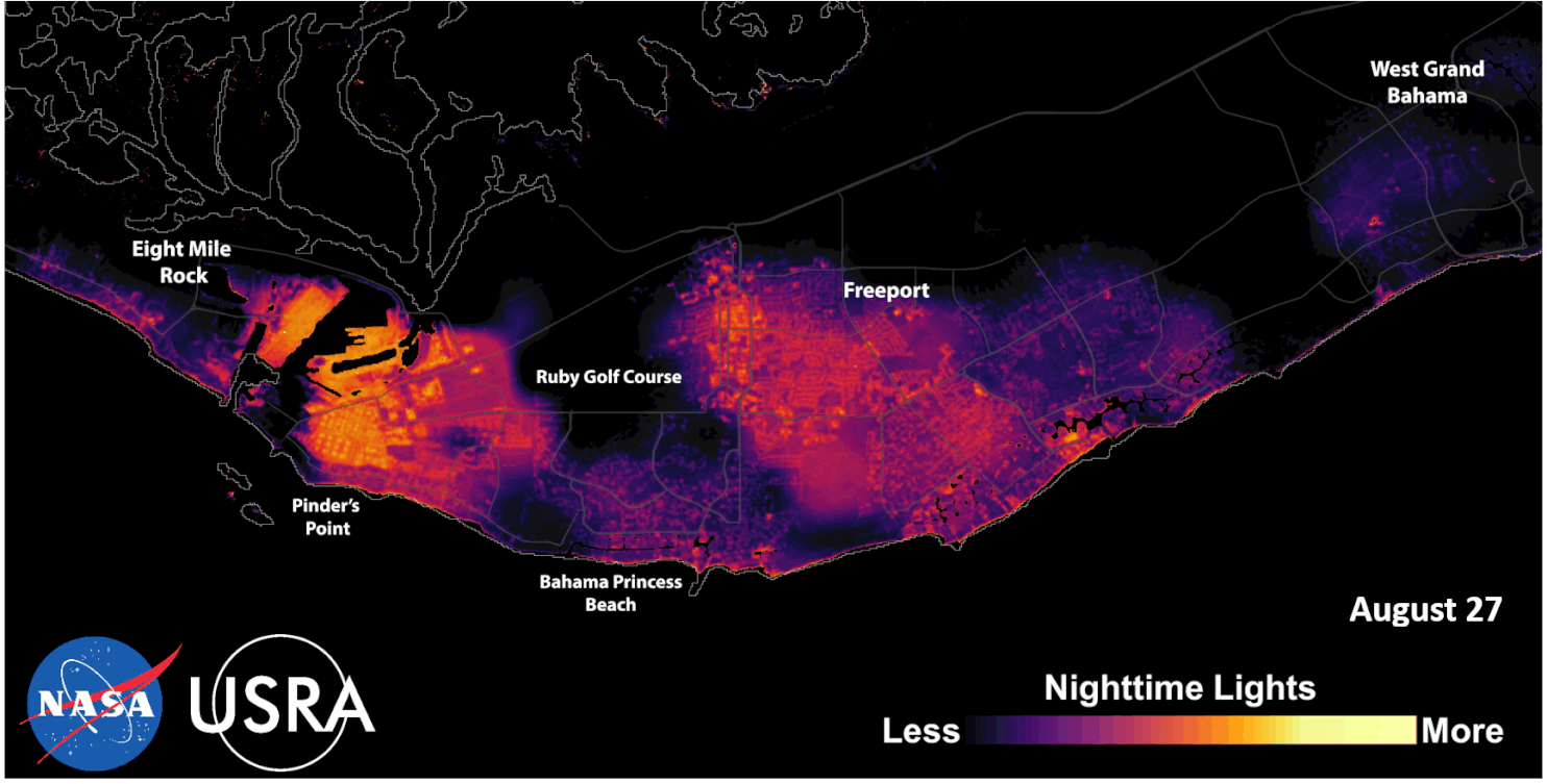
This animation of the Suomi NPP “Black Marble” product distributed by LANCE compares before (August 27th, 2019) and after (September 6th, 2019) Hurricane Dorian struck Grand Bahama Island, illustrating damage to electricity infrastructure. (Credit: NASA, USRA)
Upgraded instrument data and new data products are constantly being added to the LANCE repository. The system now features expanded atmospheric modeling capabilities, enhanced nighttime imagery from low-light visible sensing, more precise flood monitoring, and a lightning imaging sensor (LIS) installed on the International Space Station. The LIS covers an expansive geographic range that includes nearly all global lightning events and is capable of providing near real-time data within two minutes of observation, complementing the geostationary-based GOES Lightning Mapper (GLM) sensors operated by NOAA over the western Hemisphere.
“NASA will continue to spearhead new technology, demonstrating its value, and helping users become aware of what these sensors can do,” Miller said. “If these demonstrations can be done in an operationally relevant timeframe, it opens new doors. In this regard, LANCE is a kind of operational gateway—a way to fast-track technologies into routine operational use. It’s a very good story about how much more we can accomplish together.”


