Members of the NASA Earth Applied Sciences Disasters Program recently participated in the SERVIR-GEOGloWS Hackathon, a virtual app development event for participants to create geospatial and scientific web applications related to water sustainability. The Hackathon was virtually co-hosted by SERVIR, a joint venture between NASA and the U.S. Agency for International Development to provide state-of-the-art Earth observing data to improve environmental decision-making in developing nations, the Group on Earth Observations (GEO) Global Water Sustainability Program (GEOGloWS) and the Brigham Young University (BYU) Hydroinformatics Lab. The hackathon took place August 3 – 7, 2020.
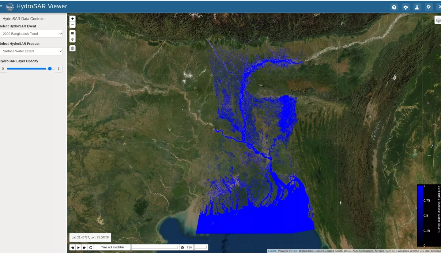
Participants in the hackathon used the Tethys Platform to develop their apps, a Python-powered software development kit that makes it easier to design and develop geospatial and scientific web applications. During the hackathon a working group led by Franz Meyer of University of Alaska Fairbanks, Principle Investigator (PI) for the NASA ROSES A.37 research project “Integrating Synthetic Aperture Radar Data for Improved Resilience and Response to Weather-Related Disasters”, prototyped a flood mapping app on the Tethys Platform called “HydroSAR Viewer”. The app allows users to display and analyze flood extent maps derived from weather-independent Sentinel-1 SAR imagery, with features including the ability to upload shapefiles, download data to a local machine, create time-series plots for a given pixel, and calculate flood extent and flood percentage for a bounding box drawn on the map. Another team lead by Dalia Kirschbaum of NASA Goddard Space Flight Center, PI for the “Development of Predictive Models to Improve Landslide Disaster Risk Reduction and Response “ A.37 project, developed an app to make global landslide hazard model data more accessible with different visualization techniques. Click here to learn more about NASA landslide research.
Each working group presented the apps they developed during the workshop at a virtual showcase on the final day, which can be viewed by clicking this link (to download, right-click the link then click "Save As"). Team Meyer’s presentation starts around 26 minutes into the video, and Team Kirschbaum’s presentation is shows 1 hour 26 minutes into the video.
In addition to app development, collaborative science discussions were held during the event. These discussions covered ongoing efforts, challenges, and potential synergies related to research in different hydrology-related application areas within the NASA Disasters Program, SERVIR, and GEOGLoWS networks, including flood monitoring and exposure data.


